
The journey from Los Angeles to Oakland is a classic Californian road trip, traversing a significant portion of the Golden State. This route offers a fascinating glimpse into the diverse landscapes and urban centers that define Southern and Northern California. Understanding the distance, travel times, and the various ways to make this trip is crucial for any traveler planning to connect these two iconic metropolises. Whether you’re seeking a direct, efficient passage or a more scenic exploration, this guide will illuminate the path.
The Direct Route: Distance and Driving Time
The most direct and commonly traveled route between Los Angeles and Oakland is predominantly via Interstate 5 (I-5), often referred to as the “Golden State Freeway.” This interstate highway is the backbone of California’s transportation network, stretching nearly 800 miles from the Mexican border to the Oregon border.

Mileage and Estimated Travel
The approximate driving distance between Los Angeles and Oakland via I-5 is around 370 to 380 miles. This figure can vary slightly depending on the exact starting and ending points within each vast metropolitan area.
The estimated driving time for this distance is typically between 5.5 to 7 hours. However, this is a highly variable metric. Several factors can significantly influence the actual time spent on the road:
- Traffic: Los Angeles and the San Francisco Bay Area, including Oakland, are notorious for heavy traffic congestion. Commute hours, particularly weekday mornings and evenings, can add hours to your journey. Traveling outside of peak times is highly recommended.
- Construction: Road work is a constant factor on major interstates like I-5. Unexpected lane closures or detours can cause delays.
- Weather: While California generally enjoys favorable weather, fog can be prevalent in coastal areas, and occasional storms can impact driving conditions, especially during winter months.
- Stops: This estimated time does not include any stops for gas, food, or rest breaks. For a journey of this length, at least one significant stop is advisable.
I-5: The Scenic (or Not-So-Scenic) Corridor
The I-5 corridor is the most efficient way to travel between these two cities, but it is not always the most visually stimulating. Much of the route passes through agricultural valleys and relatively flat terrain. Major cities you’ll pass include:
- Bakersfield: A significant agricultural hub in the Central Valley.
- Kettleman City: A common stopping point for gas and amenities.
- Coalinga: Another town in the heart of the Central Valley.
- Los Banos: A smaller city on the I-5 route.
While I-5 is designed for speed and efficiency, travelers seeking more picturesque views might consider alternative routes, though they will significantly increase travel time.
Alternative Routes and Their Distances
For travelers who have more time and wish to experience more of California’s diverse landscapes, alternative routes offer unique perspectives, albeit with a longer travel commitment.
The Coastal Route (Highway 1 / Highway 101)
The coastal route is arguably the most scenic, following portions of the iconic Pacific Coast Highway (Highway 1) and then transitioning to Highway 101. This path hugs the dramatic coastline, winds through charming beach towns, and offers breathtaking ocean vistas.
Distance and Time Considerations
This route is significantly longer and slower. The distance can easily extend to over 500 miles, and the driving time can range from 10 to 12 hours or more, not including extended stops. This is typically a multi-day journey to truly appreciate the sights.
Key highlights of this route include:
- Santa Barbara: A beautiful coastal city with Spanish architecture.
- San Luis Obispo: A vibrant college town with a historic mission.
- Big Sur: A legendary stretch of coastline with dramatic cliffs and ocean views. (Note: Portions of Highway 1 in Big Sur are subject to closures due to landslides, so always check current conditions before planning this route.)
- Monterey and Carmel-by-the-Sea: Famous for their charming streets, art galleries, and the world-renowned Monterey Bay Aquarium.
- Santa Cruz: A laid-back surf town with a classic boardwalk amusement park.
This route is ideal for those who view the drive itself as an integral part of their travel experience, focusing on destinations and scenery over speed.
The Inland Central Valley Route (Highway 99)
A compromise between the efficiency of I-5 and the beauty of the coast is to utilize Highway 99, which runs through the heart of the Central Valley. This route is generally faster than Highway 1 and offers a different perspective on California’s agricultural engine.
Distance and Time Commitment
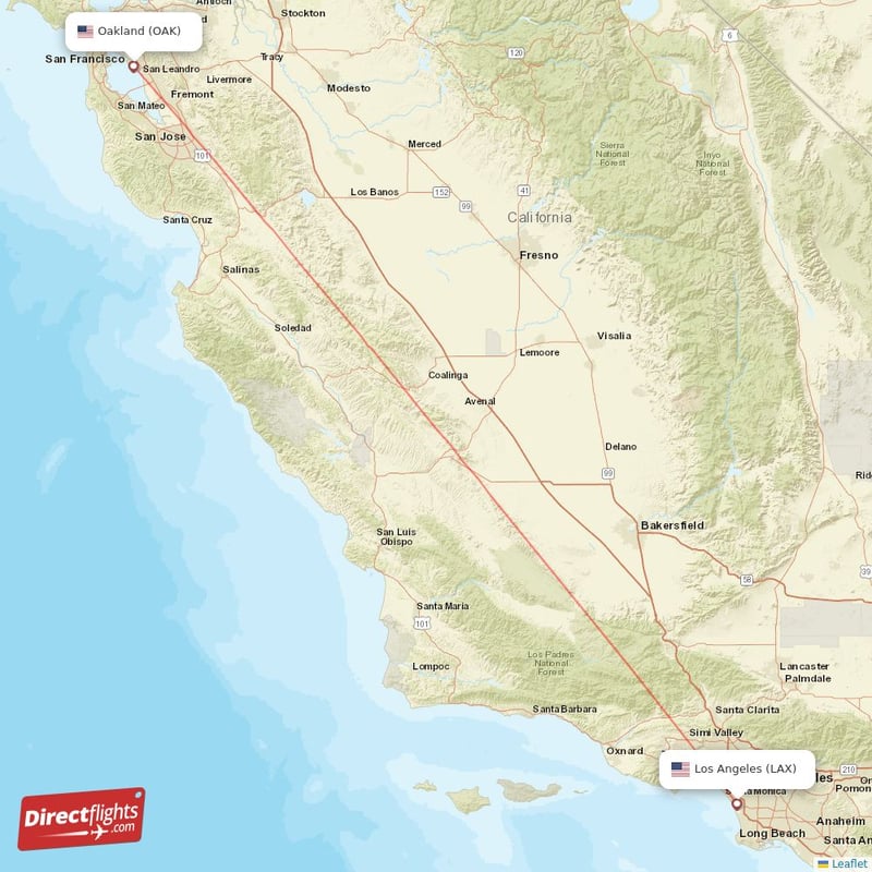
The distance via Highway 99 is comparable to I-5, around 380-400 miles. However, the driving time can be slightly longer, typically 6 to 8 hours, due to a higher number of traffic lights, lower speed limits in some sections, and passage through more towns.
Highway 99 is the primary artery for many of the state’s agricultural centers. You’ll pass through:
- Fresno: The largest city in the Central Valley.
- Modesto: Known for its dairy and almond production.
- Stockton: A major port city on the San Joaquin River.
This route can be a good option if you wish to stop in cities like Fresno or explore nearby national parks such as Yosemite National Park (though Yosemite requires a significant detour).
Choosing Your Mode of Transportation
Beyond driving, several other transportation methods can bridge the gap between Los Angeles and Oakland, each offering a distinct travel experience.
Flying
For the quickest transit, flying is the most efficient option.
- Airports: Los Angeles International Airport (LAX), Hollywood Burbank Airport (BUR), and Long Beach Airport (LGB) serve the Los Angeles area. In the Bay Area, you can fly into Oakland International Airport (OAK), San Francisco International Airport (SFO), or San Jose International Airport (SJC).
- Flight Time: The direct flight time is typically around 1 hour and 15 minutes.
- Total Travel Time: Factor in travel to and from airports, check-in, security, and baggage claim, and the total door-to-door time can be similar to or slightly longer than driving, but without the stress of traffic.
- Airlines: Numerous airlines, including Southwest Airlines, United Airlines, and American Airlines, operate frequent flights on this popular route.
Train Travel (Amtrak)
Amtrak offers a more relaxed, scenic, and environmentally conscious way to travel between Los Angeles and Oakland.
- Route: The most common Amtrak route involves taking the San Joaquins service. You would typically depart from Los Angeles Union Station and travel to a transfer point, then connect to a bus that takes you to the Oakland Jack London Square Station or Emeryville Station.
- Duration: This journey is considerably longer than driving, often taking 8 to 10 hours or more, depending on connections.
- Experience: Amtrak offers comfortable seating, the ability to walk around, dining cars, and scenic views that you would miss from the highway. It’s a great option for those who prefer not to drive or fly.
Bus Services
Several intercity bus companies operate between Los Angeles and Oakland, offering a budget-friendly option.
- Providers: Companies like Greyhound, FlixBus, and Megabus offer services.
- Duration: Travel times can vary significantly based on the number of stops and the route taken, often ranging from 7 to 10 hours.
- Comfort and Amenities: While generally more basic than train travel, many modern buses offer Wi-Fi and power outlets. This is a practical choice for budget-conscious travelers.
Planning Your Journey: Tips for a Smooth Trip
Regardless of your chosen method, proper planning is key to a successful journey from Los Angeles to Oakland.
For Drivers
- Navigation: Utilize GPS apps like Google Maps or Waze, which provide real-time traffic updates and suggest alternative routes if congestion becomes severe.
- Vehicle Check: Ensure your vehicle is in good condition, with properly inflated tires, sufficient oil, and a full tank of gas before departing.
- Rest Stops: Plan for regular breaks to avoid fatigue. California has numerous well-maintained rest areas along I-5.
- Snacks and Water: Carry plenty of water and snacks, especially if traveling on I-5, where services can be spread out between major towns.
For Train and Bus Travelers
- Book in Advance: Especially during peak travel seasons, booking tickets in advance can secure better prices and ensure availability.
- Check Schedules: Verify departure and arrival times, as well as any potential delays or service alerts.
- Pack Smart: Bring a neck pillow, entertainment (books, downloaded movies), and snacks, as onboard amenities can vary.
General Travel Advice
- Time of Year: Consider the time of year you are traveling. Summer can mean higher temperatures in the Central Valley and more crowded conditions. Winter may bring rain.
- Flexibility: Build some flexibility into your schedule, especially if your travel plans are dependent on traffic or potential delays.
- Accommodation: If you are making this trip over multiple days, research and book accommodations in advance in towns along your chosen route.
The distance between Los Angeles and Oakland is more than just a number of miles; it represents a transition across a diverse and dynamic state. By understanding the options and planning accordingly, you can ensure your journey is as enjoyable and efficient as possible, whether you’re seeking the fastest route or a leisurely exploration of California.
LifeOutOfTheBox is a participant in the Amazon Services LLC Associates Program, an affiliate advertising program designed to provide a means for sites to earn advertising fees by advertising and linking to Amazon.com. Amazon, the Amazon logo, AmazonSupply, and the AmazonSupply logo are trademarks of Amazon.com, Inc. or its affiliates. As an Amazon Associate we earn affiliate commissions from qualifying purchases.