
Embarking on a journey from Atlanta to Florida is a popular travel endeavor, connecting the vibrant urban landscape of Georgia to the sun-drenched beaches and diverse attractions of the Sunshine State. The answer to “how far” is not a single number, but rather a nuanced understanding of geography, transportation methods, and the specific Florida destination you aim to reach. This exploration delves into the distances, driving times, and considerations for planning your travel from Atlanta to various points across Florida.
Understanding the Distance: A State-to-State Perspective
Florida is a large state, stretching approximately 450 miles from its northern border to its southern tip. This means the distance from Atlanta will vary significantly depending on your intended destination within the state.

Northern Florida Destinations
For those venturing to northern Florida, such as Jacksonville or the Panhandle, the distance is considerably shorter.
Jacksonville, Florida
Jacksonville, situated on the Atlantic coast, is one of the closest major cities to Atlanta. The driving distance is approximately 345 miles, typically taking around 5 to 5.5 hours without significant traffic delays. This makes it a feasible weekend getaway destination for many residents of the Atlanta metropolitan area. The route primarily follows Interstate 10 for a substantial portion, a well-maintained highway offering a relatively direct path.
Pensacola, Florida (Panhandle)
Venturing further west into the Florida Panhandle to cities like Pensacola increases the mileage. The drive from Atlanta to Pensacola is roughly 500 miles, translating to an estimated driving time of 7.5 to 8 hours. This journey typically involves navigating Interstate 85 South and then transitioning to Interstate 10 West.
Central Florida Destinations
Central Florida is home to some of the state’s most iconic attractions, including theme parks and vibrant cities.
Orlando, Florida
The pilgrimage to the theme park capital of the world, Orlando, is a common travel goal. The distance from Atlanta to Orlando is approximately 440 miles. The drive typically takes between 6.5 to 7.5 hours. The most common route involves taking Interstate 75 South, which then connects to various state roads and highways leading into Orlando. This route often passes through cities like Valdosta, Georgia, and Gainesville, Florida.
Tampa, Florida
Located on the west coast of central Florida, Tampa offers a different coastal experience with its own set of attractions, including Busch Gardens and a lively downtown area. The driving distance from Atlanta to Tampa is around 470 miles. This journey generally takes about 7 to 8 hours. The route often utilizes Interstate 75 South for the majority of the trip.
Southern Florida Destinations
The southern reaches of Florida are synonymous with tropical climates, stunning beaches, and vibrant metropolises.
Miami, Florida
Reaching the southernmost major metropolitan area, Miami, from Atlanta represents the longest common travel distance. The drive to Miami is approximately 650 miles. This substantial journey typically requires 9.5 to 11 hours of driving time, making it a trip best suited for an overnight stop or an early start. The route primarily involves Interstate 75 South for a considerable distance, eventually transitioning to highways that lead towards the Miami metropolitan area.
Fort Lauderdale, Florida
Often considered a twin city to Miami in terms of travel, Fort Lauderdale lies just north of Miami and shares similar travel considerations. The distance and driving time are very close to that of Miami, with approximately 645 miles and a travel time of 9.5 to 10.5 hours.
Planning Your Travel: Modes of Transportation and Considerations
The “how far” question also extends to the practicalities of the journey. Several modes of transportation can bridge the gap between Atlanta and Florida, each with its own advantages.
Driving
Driving is by far the most popular method of travel for this route, offering flexibility and the ability to carry more luggage. The highway infrastructure is generally excellent, with well-maintained Interstates forming the backbone of the journey.
Route Planning and Navigation
Utilizing GPS navigation systems and mapping applications is highly recommended. These tools provide real-time traffic updates, alternative routes, and estimated arrival times, crucial for navigating potential delays, especially around major cities like Atlanta, Orlando, and Miami. Planning stops for fuel, meals, and rest is essential for a safe and enjoyable road trip. Consider breaking longer journeys into two days, especially for destinations in southern Florida, with an overnight stay in cities like Valdosta, Gainesville, or along the Florida Turnpike.
Fuel Costs and Vehicle Maintenance
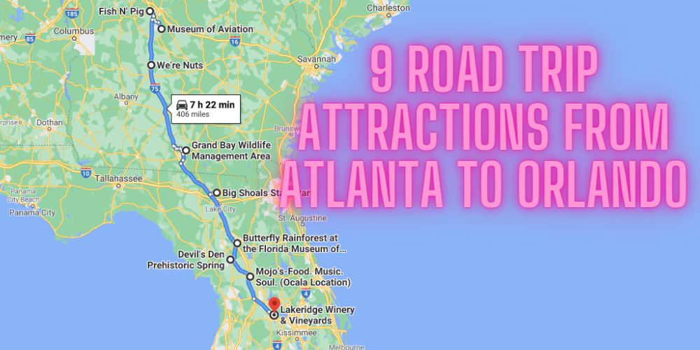
Fuel consumption is a significant factor in driving costs. The exact cost will depend on the vehicle’s fuel efficiency and current gas prices in Georgia and Florida. Ensuring your vehicle is in good mechanical condition before embarking on a long drive is paramount. Check tire pressure, oil levels, and brakes to prevent breakdowns.
Air Travel
For those prioritizing speed and minimizing travel time, flying is an excellent option. Hartsfield-Jackson Atlanta International Airport is one of the busiest airports in the world, offering numerous daily flights to major Florida airports.
Major Florida Airports
- Orlando International Airport (MCO): Serves as a gateway to Orlando’s theme parks and central Florida attractions.
- Miami International Airport (MIA): The primary airport for Miami, Fort Lauderdale, and the surrounding South Florida region.
- Tampa International Airport (TPA): The main airport for the Tampa Bay area, including St. Petersburg.
- Jacksonville International Airport (JAX): Serves Jacksonville and northern Florida.
- Southwest Florida International Airport (RSW) (Fort Myers): Serves the southwest coast of Florida.
Flight times from Atlanta to these Florida cities are typically between 1.5 to 2 hours. However, it’s crucial to factor in travel time to and from airports, security checks, and potential flight delays when calculating the total travel time.
Bus and Train Travel
While less common for this specific route compared to driving or flying, bus and train services do operate between Atlanta and various points in Florida.
Bus Services
Companies like Greyhound offer intercity bus travel. Journeys can be lengthy, often exceeding 10-12 hours depending on the destination and the number of stops. This option can be more budget-friendly but sacrifices comfort and speed.
Train Services
Amtrak operates train routes that connect Atlanta with cities in Florida, such as Jacksonville and Miami. The train journey offers a more relaxed pace and scenic views, but it is generally the slowest mode of transport, with travel times often exceeding 12-15 hours.
Navigating Through Florida: Intra-State Distances
Once you arrive in Florida, the distances between popular destinations can still be significant, influencing your itinerary and travel plans within the state.
From Orlando to Other Florida Hotspots
- Orlando to Miami: Approximately 235 miles, about a 3.5 to 4-hour drive. This route is predominantly via the Florida Turnpike.
- Orlando to Tampa: Approximately 85 miles, about a 1.5-hour drive via Interstate 4.
- Orlando to Key West: This is a substantial extension, involving driving through the Keys. The journey from Orlando to Key West is over 400 miles and can take 8-9 hours of driving time, including navigating the scenic but often traffic-prone Overseas Highway.
From Miami to Other Florida Hotspots
- Miami to Fort Lauderdale: Approximately 30 miles, a short 30-45 minute drive.
- Miami to Naples: Located on the west coast, this drive is about 160 miles and takes roughly 3 hours via Alligator Alley (Interstate 75).
- Miami to Key West: This iconic drive covers approximately 160 miles from mainland Florida and takes about 3.5 to 4 hours, with numerous islands and bridges to traverse.
Factors Influencing Travel Time
Beyond raw distance, several factors can influence the actual time it takes to travel from Atlanta to Florida.
Traffic Conditions
Atlanta and many Florida cities are known for their traffic congestion, particularly during peak hours, holidays, and weekends. The I-75 and I-10 corridors can experience significant slowdowns, especially near major urban centers. Planning your departure and arrival times to avoid rush hour can save considerable time.
Road Construction and Detours
Road construction is a constant factor on major highways. Unexpected detours or lane closures can add to travel time. Staying informed through traffic apps and local news can help mitigate these disruptions.
Weather
While Florida is known for its sunshine, tropical storms and hurricanes can impact travel during hurricane season (June 1st to November 30th). Even heavy rain can slow down traffic and reduce visibility, extending driving times.

Time Zones
Atlanta, Georgia is in the Eastern Time Zone. Most of Florida is also in the Eastern Time Zone. However, a small portion of the western Florida Panhandle observes the Central Time Zone. This difference, while minor, is something to be aware of if your destination is in that specific region.
In conclusion, the distance from Atlanta to Florida is a variable, with the precise mileage and travel time depending heavily on your specific Florida destination and chosen mode of transportation. Whether you’re heading for the theme parks of Orlando, the beaches of Miami, or the historic charm of St. Augustine, careful planning and consideration of these factors will ensure a smooth and enjoyable journey.
LifeOutOfTheBox is a participant in the Amazon Services LLC Associates Program, an affiliate advertising program designed to provide a means for sites to earn advertising fees by advertising and linking to Amazon.com. Amazon, the Amazon logo, AmazonSupply, and the AmazonSupply logo are trademarks of Amazon.com, Inc. or its affiliates. As an Amazon Associate we earn affiliate commissions from qualifying purchases.