
The question “How far is Nevada from California?” might seem simple, yet its answer unveils a diverse tapestry of distances, landscapes, and travel experiences that beckon adventurers and commuters alike. As neighboring states, they share a significant border, making the journey between them incredibly accessible, though the specifics depend heavily on your exact starting point in California and your destination in Nevada. This geographical proximity facilitates everything from quick weekend getaways to vital cross-state commutes, tying the economies and cultures of both regions together. Understanding the practical distances and travel implications is key to planning any successful trip across this vibrant frontier.

Understanding the Proximity: A Shared Border and Diverse Landscapes
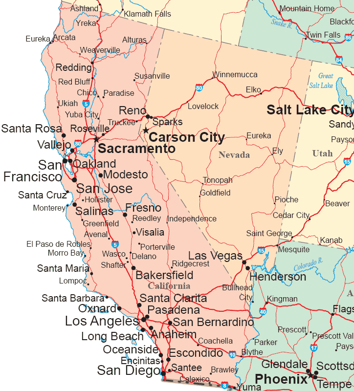
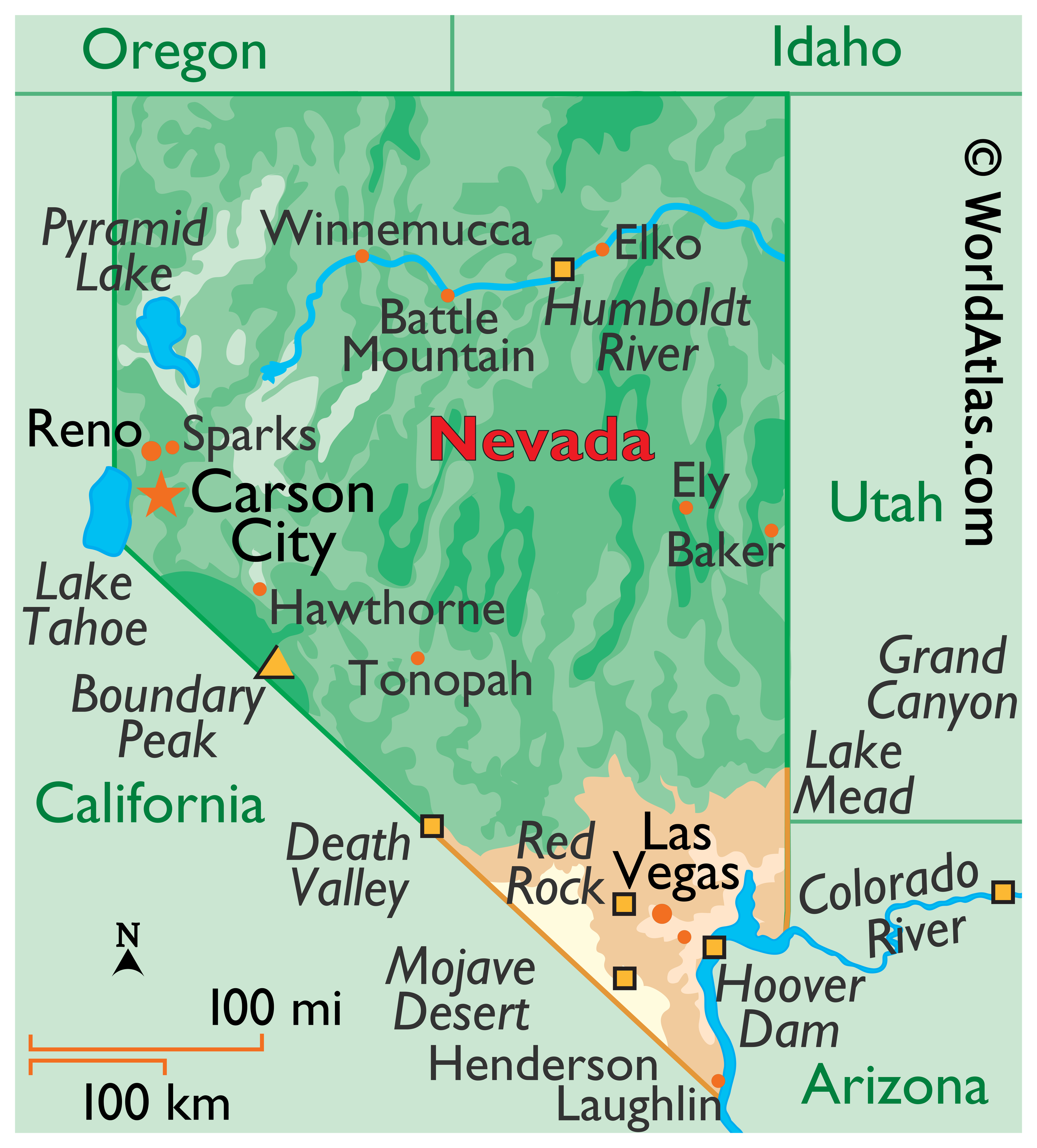
California and Nevada share a long, intricate border that stretches from the arid south, cutting through the vast expanse of the Mojave Desert, to the majestic peaks of the Sierra Nevada mountain range in the north. This shared boundary means that, in many places, merely crossing a street or a state line sign is enough to transition between the two. However, the travel experience and distance can vary dramatically based on where along this extensive border you intend to cross.
In the south, the major travel corridor connects Southern California to Southern Nevada, with Las Vegas serving as the primary magnet. Here, the landscape is largely desert, offering long, relatively flat stretches of highway conducive to straightforward driving. Further north, the dynamic changes as the border climbs into the Sierra Nevada, where Lake Tahoe straddles both states, presenting a more winding, mountainous terrain that impacts travel times and conditions, especially during winter months. This geographical diversity means that “how far” isn’t a single answer, but rather a spectrum of distances and journey types.
Driving the Distance: Key Routes and Times
For most travelers, driving is the preferred method of crossing between California and Nevada, offering flexibility and the opportunity to explore the diverse landscapes. The major interstates and highways are well-maintained, though conditions can vary seasonally.
The Southern California to Southern Nevada Corridor
This is arguably the most traveled route, connecting millions in Southern California to the entertainment capital of Las Vegas.
- Los Angeles to Las Vegas: The most common journey, primarily via Interstate 15 (I-15). The distance is approximately 270 miles to 300 miles, depending on your exact starting point in Los Angeles and destination in Las Vegas. Under ideal conditions, this drive takes about 4 to 5 hours. However, traffic, especially on Friday afternoons and Sunday evenings, can significantly extend this, sometimes to 6-8 hours or more.
- San Diego to Las Vegas: This route typically involves heading north on Interstate 15 (I-15) as well. The distance is roughly 330 miles, translating to a driving time of 5 to 6 hours without heavy traffic.
Northern California to Northern Nevada Routes
Connecting the Bay Area and Sacramento to cities like Reno and the Lake Tahoe area.
- San Francisco to Reno: This journey often uses Interstate 80 (I-80) and covers approximately 220 miles. The drive typically takes 3.5 to 4 hours, traversing through Sacramento and then ascending into the Sierra Nevada mountains.
- Sacramento to Reno: A shorter trip of about 130 miles, taking roughly 2 to 2.5 hours via Interstate 80 (I-80).
- San Francisco to Lake Tahoe (South Lake Tahoe/Stateline): Similar to the Reno route, travelers use Interstate 80 (I-80) to Truckee and then US Route 50 (US-50) or US Route 395 (US-395) to the lake. The distance is about 180-200 miles, with driving times around 3.5 to 4.5 hours, heavily dependent on traffic and weather in the mountains.
Navigating the Eastern Sierra
For those seeking scenic beauty, US Route 395 (US-395) is a popular choice, running along the Eastern Sierra through towns like Mammoth Lakes in California and connecting to destinations in central Nevada. While not a direct route between major urban centers, it’s a crucial artery for access to national parks like Yosemite National Park (via seasonal passes) and Death Valley National Park that straddle the border. Distances here are variable, often involving several hours of driving between points of interest.
Beyond the Wheel: Alternative Travel Modes
While driving offers unparalleled freedom, other modes of transport provide viable alternatives for crossing the California-Nevada border, each with its own advantages.
Taking to the Skies
For those prioritizing speed, flying is the most efficient option for longer distances.
- Los Angeles (LAX) to Las Vegas (Harry Reid International Airport): This is one of the busiest air routes in the country, with numerous daily flights. The flight time is typically around 1 hour to 1 hour and 15 minutes. Factoring in airport security, boarding, and deplaning, total travel time from city center to city center can be around 3-4 hours, often comparable to driving without heavy traffic, but without the physical strain.
- San Francisco (SFO or Oakland (OAK)) to Reno (Reno-Tahoe International Airport): Direct flights are available, with a flight duration of about 1 hour. Similar to Las Vegas, door-to-door travel time will be longer due to airport procedures.
Ground Transportation Alternatives
For those who prefer not to drive but still want a ground-level view, bus and train services connect key cities.
- Bus Services: Companies like Greyhound and various smaller regional carriers offer routes between major California cities (Los Angeles, San Francisco, Sacramento) and Nevada destinations (Las Vegas, Reno). Bus travel is generally the most budget-friendly option, though it is also the slowest. For instance, a bus trip from Los Angeles to Las Vegas can take 5.5 to 7 hours, depending on stops.
- Train Services: Amtrak offers limited service directly between the states. The California Zephyr route connects Emeryville (near San Francisco and Oakland) to Reno and beyond into Nevada. While scenic, train travel is typically slower than driving or flying for these particular routes, often taking 6-7 hours from the Bay Area to Reno. It’s more about the journey and comfort than speed.
Planning Your Journey: Tips for a Seamless Trip
Regardless of your chosen mode of transport, a well-planned trip between California and Nevada can greatly enhance the experience.
Seasonal Considerations
The diverse geography means weather plays a significant role in travel logistics:
- Summer: The desert routes to Las Vegas can be intensely hot. Ensure your vehicle is in good condition, carry plenty of water, and be aware of potential monsoons or dust storms. Mountain passes are clear and offer beautiful driving conditions.
- Winter: The Sierra Nevada routes (Interstate 80 (I-80), US Route 50 (US-50), and higher elevations of US Route 395 (US-395)) can experience heavy snowfall, requiring tire chains or 4WD/AWD vehicles. Road closures are not uncommon. Always check road conditions (Caltrans and Nevada Department of Transportation) before embarking on a winter mountain journey.
- Spring/Fall: Generally offer the most pleasant travel conditions, with milder temperatures across both desert and mountain regions.
Essential Road Trip Tips
- Fuel and Hydration: Especially on desert routes, plan your fuel stops. While services are available on Interstate 15 (I-15), stretches can be long. Always carry water, particularly if traveling during warmer months.
- Traffic Awareness: Use navigation apps that provide real-time traffic updates. Weekend travel, especially to Las Vegas, can see significant delays. Consider departing very early in the morning or late at night to avoid peak traffic.
- Vehicle Maintenance: A pre-trip check of tires, oil, and fluids is highly recommended, especially for long drives or journeys through extreme temperatures.
- Breaks and Scenic Stops: Factor in time for breaks. Along Interstate 15 (I-15), roadside attractions like Calico Ghost Town or the Mojave National Preserve can offer interesting diversions. For mountain routes, countless viewpoints and small towns provide opportunities to stretch your legs and enjoy the scenery.
The Journey’s Appeal: What Awaits Across the Border
The relatively short distances between major population centers make crossing from California to Nevada, and vice-versa, an appealing prospect for various reasons. For Californians, Nevada offers unique entertainment, gambling, and outdoor recreation, from the glittering lights of Las Vegas to the ski resorts and natural beauty of the Lake Tahoe area and Reno. For Nevadans, California provides access to stunning coastlines, diverse metropolitan areas like San Francisco and Los Angeles, and world-class national parks.
The journey itself, whether a quick flight or a scenic road trip, is an integral part of the experience. It allows travelers to witness the dramatic shift from coastal plains and bustling cities to vast deserts and towering mountains. From planning the most efficient route to anticipating traffic and enjoying the changing scenery, understanding the “how far” between California and Nevada is the first step in unlocking a world of travel possibilities right next door.
LifeOutOfTheBox is a participant in the Amazon Services LLC Associates Program, an affiliate advertising program designed to provide a means for sites to earn advertising fees by advertising and linking to Amazon.com. Amazon, the Amazon logo, AmazonSupply, and the AmazonSupply logo are trademarks of Amazon.com, Inc. or its affiliates. As an Amazon Associate we earn affiliate commissions from qualifying purchases.