
Embarking on a journey from the bustling urban sprawl of New York to the rugged, salt-sprayed coastlines of Maine is a quintessential American road trip experience. This transition from the concrete canyons of the most populous city in the United States to the tranquil lighthouses and pine-forested vistas of the “Pine Tree State” captures the quintessential essence of the Northeastern United States. Understanding the distance, the logistics, and the best ways to traverse this corridor is the first step toward planning an unforgettable escape.
Calculating the Miles: Distances and Routes
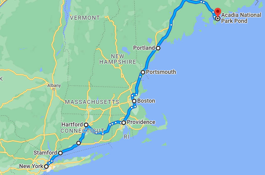
When mapping the journey from New York City to the border of Maine, travelers are looking at a trip that spans several states. While the exact mileage depends on your specific destination within Maine—as the state is surprisingly large—the distance from the heart of the city to the southern Maine border town of Kittery is approximately 300 miles.
The Interstate Corridor
Most travelers opting for a road trip will navigate via Interstate 95, which acts as the primary artery connecting the Mid-Atlantic to New England. This route takes you through the heart of Connecticut, Rhode Island, and Massachusetts. Under optimal traffic conditions, this drive typically takes between five to six hours to reach the Maine state line. However, given the density of the Northeast Corridor, traffic near New Haven, Providence, and Boston can easily add several hours to your travel time.
Traveling Further North
If your goal is to reach Portland, Maine’s vibrant cultural and culinary hub, you should add roughly one hour to your drive time beyond the state border. For those venturing further toward the iconic Acadia National Park or the rugged terrain of Bar Harbor, the journey extends significantly, often totaling eight to ten hours of pure driving time from New York City.
Modes of Transportation: Choosing Your Path
While driving offers the most flexibility for exploring the scenic backroads of New England, it is not the only way to bridge the distance. Depending on your personal preference for speed, budget, and comfort, there are several reliable ways to make the trek.
Rail Travel via Amtrak
For those who prefer to avoid the stress of driving through heavy traffic, Amtrak provides a reliable alternative. You can take the Northeast Regional train from Penn Station to Boston, and then transfer to the Downeaster, which services several coastal towns in Maine. This option allows you to enjoy the changing scenery without the fatigue of long-distance navigation. It is a particularly popular choice for travelers heading toward Brunswick or Portland.
Air Travel Considerations
Flying is the quickest way to cover the distance. Direct flights are available from John F. Kennedy International Airport or LaGuardia Airport into the Portland International Jetport. With a flight time of roughly one hour and fifteen minutes, it is the most time-efficient method, though it lacks the slow-paced exploration of the coastal towns along the way.
Strategic Stops Along the Way
Breaking up the drive is highly recommended, as the route from New York to Maine passes through some of the most historically and culturally significant areas of the country. Turning a six-hour drive into a two-day excursion can significantly enhance your travel experience.
Historic New Haven and Providence
As you navigate through Connecticut, a stop in New Haven offers a chance to explore Yale University and grab some of the best pizza in the country. Continuing north, Providence, Rhode Island, provides a sophisticated stopover with its vibrant arts scene and historic riverside architecture.
The Boston Buffer
Boston is perhaps the most obvious midway point. Whether you are walking the Freedom Trail or grabbing a bite in the North End, the city serves as a perfect cultural pivot point before the landscape begins to shift toward the rocky beaches of the northern Atlantic coast. If you choose to bypass the city center, the coastal towns of Newburyport or Portsmouth, New Hampshire, serve as fantastic gateways just before you cross the Piscataqua River Bridge into Maine.
Best Times to Travel and Tips for the Road
The distance between New York and Maine feels different depending on the season. Summer is peak tourism season, offering warm weather, whale watching, and lobster festivals, but it also means heavier traffic on Interstate 95. Autumn, however, is widely considered the most spectacular time to make the trip. As the foliage turns vibrant shades of orange, yellow, and red, the drive becomes a scenic masterpiece, particularly once you cross into New England.
Avoiding Traffic Peaks
To minimize the impact of the distance, try to avoid departing New York City on Friday afternoons or returning on Sunday evenings. These windows are infamous for congestion near major hubs like Stamford and Hartford. Early morning departures on weekdays often result in a much smoother, more enjoyable travel experience.

Preparing for Your Maine Destination
Once you arrive, remember that the sheer beauty of Maine is its scale. Whether you are visiting the Portland Head Light in Cape Elizabeth or trekking the trails of Mount Desert Island, allow yourself extra time to navigate the slower, winding coastal roads. While the drive from New York is a straightforward calculation of miles, the journey itself is defined by the unique character of the towns and landscapes you encounter. Preparation, combined with a willingness to explore the unexpected stops along the Northeast Corridor, will ensure that the journey is just as memorable as your final destination in the beautiful state of Maine.
LifeOutOfTheBox is a participant in the Amazon Services LLC Associates Program, an affiliate advertising program designed to provide a means for sites to earn advertising fees by advertising and linking to Amazon.com. Amazon, the Amazon logo, AmazonSupply, and the AmazonSupply logo are trademarks of Amazon.com, Inc. or its affiliates. As an Amazon Associate we earn affiliate commissions from qualifying purchases.