
Embarking on a journey between two of California’s distinct locales, San Francisco and Fresno, offers a fascinating glimpse into the diverse landscapes and experiences the Golden State holds. Whether you’re planning a scenic road trip, considering a business excursion, or simply curious about the geography that shapes daily commutes for many Californians, understanding the distance and the nuances of travel between these two cities is paramount. The proximity, or perceived lack thereof, between San Francisco and Fresno is a frequent query for both residents and visitors, touching upon practical travel logistics and the broader context of regional connectivity within California. This exploration delves into the measured distances, the varied travel methods, and the unique characteristics of each city that influence travel decisions.
Navigating the Distance: Mileage and Travel Times
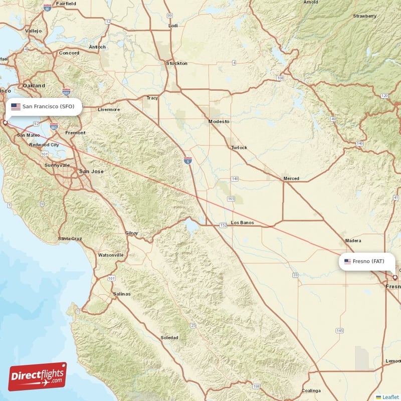
The most direct answer to “How far is San Francisco from Fresno?” lies in the mileage and the estimated travel time by road. Geographically, these two urban centers are separated by approximately 170 to 180 miles, depending on the specific starting and ending points within each city and the chosen route. This distance positions them as reachable destinations for a day trip or a weekend getaway, yet significant enough to warrant planning.
Driving Routes and Considerations
The primary corridor connecting San Francisco and Fresno is California State Route 99, often referred to as the “Golden State Highway.” This major north-south freeway bisects the state’s central valley, offering a relatively straightforward drive. Travelers typically depart from the San Francisco Bay Area via routes like Interstate 580 or U.S. Route 101 to connect with SR 99 south.
The estimated driving time, under ideal conditions, is usually between 3 to 3.5 hours. However, this figure is heavily influenced by several factors:
- Traffic Congestion: The San Francisco Bay Area is notorious for its traffic, especially during peak commuting hours. Exiting the metropolitan area can add substantial time to the journey. Similarly, approaching Fresno during rush hour can also cause delays.
- Road Construction and Detours: Like any major highway system, sections of SR 99 or connecting roads may be under construction, necessitating detours and adding to travel time. It is always advisable to check real-time traffic conditions before departing.
- Weather Conditions: While the central valley generally experiences dry weather for much of the year, winter months can bring fog or rain, which can slow down travel. The mountainous passes sometimes used for alternative routes are more susceptible to weather-related closures.
- Stops and Breaks: The 3-3.5 hour estimate assumes a non-stop journey. Most travelers will opt for at least one stop for fuel, food, or rest, extending the overall duration of their trip.
Alternative Driving Routes
While SR 99 is the most common route, other options exist, often chosen for scenic value or to avoid heavy truck traffic. One such alternative involves utilizing U.S. Route 101 further south and then heading inland, or taking Interstate 5 directly.
- Interstate 5 Route: This route is generally faster in terms of pure mileage and traffic flow, but it can be less scenic and potentially more monotonous. It involves heading south from the Bay Area on I-580 or US-101 to connect with I-5 south, and then exiting for Fresno when appropriate. The travel time might be similar or slightly less than the SR 99 route, but it bypasses many of the agricultural towns that dot the central valley.
The choice of route often depends on the traveler’s priorities: speed and efficiency versus a more varied landscape and local flavor.
Beyond the Road: Air and Rail Travel Options
While driving is the predominant mode of transportation between San Francisco and Fresno, other options cater to those seeking different travel experiences or time-saving solutions.
Air Travel
For those prioritizing speed, air travel is a viable, albeit more complex, option. San Francisco is served by several major airports, including San Francisco International Airport (SFO), Oakland International Airport (OAK), and San Jose International Airport (SJC). Fresno Yosemite International Airport (FAT) serves the Fresno metropolitan area.
- Flight Duration: Direct flights between the Bay Area and Fresno are typically very short, often under an hour.
- Total Travel Time: However, the overall travel time must account for reaching the airport, check-in procedures, security screening, boarding, deplaning, and transportation from Fresno Yosemite International Airport (FAT) to your final destination. This can easily make the total journey comparable to, or even longer than, driving.
- Cost: Airfare can fluctuate significantly based on booking time, airline, and demand. For many travelers, the cost of a flight might exceed the expenses of driving, especially for groups or families.
Rail Travel
Amtrak offers a rail service that connects the two cities, providing a more relaxed and scenic alternative to driving or flying. The primary route involves the San Joaquins route.
- Route and Duration: The journey typically involves taking a bus connection from the San Francisco area (often from the San Francisco Transbay Terminal) to a train station in the Bay Area like Oakland or Martinez, where you board the train heading south towards Fresno. The train journey itself can take approximately 4 to 5 hours, depending on the specific service and any intermediate stops.
- Advantages: Rail travel allows passengers to avoid traffic, relax, enjoy the passing scenery of the central valley, and often work or read comfortably. Onboard amenities can include Wi-Fi and dining services.
- Considerations: The overall travel time by train, including the bus connection, might be longer than driving. Furthermore, the stations in Fresno may not be as centrally located as desired, requiring additional local transportation.
Understanding the Geography and Context
The distance between San Francisco and Fresno is not just a matter of miles; it represents a transition between two very different Californian environments. San Francisco, perched on the tip of a peninsula, is known for its iconic fog, hilly terrain, vibrant cultural scene, and its role as a global hub for technology and finance. It is a coastal city deeply influenced by the Pacific Ocean and the San Francisco Bay.
Fresno, on the other hand, is the largest city in California’s central valley. It is characterized by its agricultural heartland, with the surrounding fertile lands producing a significant portion of the nation’s fruits, nuts, and vegetables. The climate in Fresno is typically hotter and drier than in San Francisco, with less coastal influence. Its proximity to the Sierra Nevada mountains makes it a gateway to national parks like Yosemite and Sequoia & Kings Canyon National Parks.
The journey from San Francisco to Fresno therefore involves a gradual shift in topography, climate, and economy. As you drive east and south from the Bay Area, the rolling hills and coastal scrub give way to the vast, flat expanses of the central valley, punctuated by orchards and agricultural fields. This transition is a key aspect of the travel experience, offering a visual narrative of California’s diverse geography.
Practical Travel Planning Tips
When planning a trip between San Francisco and Fresno, a few practical considerations can enhance the journey.
Timing Your Departure
To minimize traffic delays, it is highly recommended to avoid departing from the San Francisco Bay Area during weekday morning or evening commute hours. Traveling mid-morning or early afternoon on weekdays, or during the weekend, generally offers a smoother experience. Likewise, consider traffic patterns when arriving in Fresno.
Utilizing Navigation Tools
Modern navigation applications and GPS devices are invaluable for this route. They provide real-time traffic updates, suggest alternative routes in case of significant congestion or accidents, and offer accurate estimated times of arrival. Services like Google Maps, Waze, or Apple Maps can be your best companion.
Planning Stops
Given the driving time, planning for at least one stop is advisable. Towns along SR 99 offer various options for rest stops, gas stations, and eateries. Larger towns like Modesto or Merced provide more comprehensive services. Consider stopping to refuel and perhaps grab a meal or coffee to break up the drive.
Vehicle Maintenance
Ensure your vehicle is in good condition before embarking on the journey. Check tire pressure, fluid levels, and brakes. This is particularly important if traveling during hot weather, as cars can be more prone to overheating.

Accommodation in Fresno
If your visit to Fresno involves an overnight stay, numerous hotel options are available, ranging from budget-friendly motels to more upscale establishments. Popular areas for accommodation include those near the airport, downtown Fresno, or along the main thoroughfares. Popular hotel chains often have a presence, such as Holiday Inn, Best Western, and Courtyard by Marriott, offering various amenities to suit different traveler needs. Booking in advance is often recommended, especially during peak travel seasons or local events.
Ultimately, the distance between San Francisco and Fresno is a bridgeable one, offering a transition between distinct facets of California. Understanding the travel options and planning accordingly will ensure a smooth and enjoyable journey, whether you’re heading to the agricultural heartland or departing from the bustling coastal metropolis.
LifeOutOfTheBox is a participant in the Amazon Services LLC Associates Program, an affiliate advertising program designed to provide a means for sites to earn advertising fees by advertising and linking to Amazon.com. Amazon, the Amazon logo, AmazonSupply, and the AmazonSupply logo are trademarks of Amazon.com, Inc. or its affiliates. As an Amazon Associate we earn affiliate commissions from qualifying purchases.