
The question of distance between two of California’s most iconic cities, San Francisco and Los Angeles, is a perennial one for travelers, road trippers, and anyone planning a journey along the Golden State’s legendary coast. While seemingly straightforward, the answer is nuanced, depending heavily on the mode of transport and the specific route taken. Understanding these variations is key to planning an efficient and enjoyable trip, whether you’re seeking a scenic adventure or a swift transition between these cultural hubs.
Understanding the Distance: By the Numbers
The most direct measurement of the distance between San Francisco and Los Angeles is the approximate 380 miles (612 kilometers) as the crow flies. This aerial distance, however, is rarely how travelers experience the journey. For practical purposes, the actual driving or flying distance is more relevant.
Driving Distance: The Coastal Classic and the Inland Route
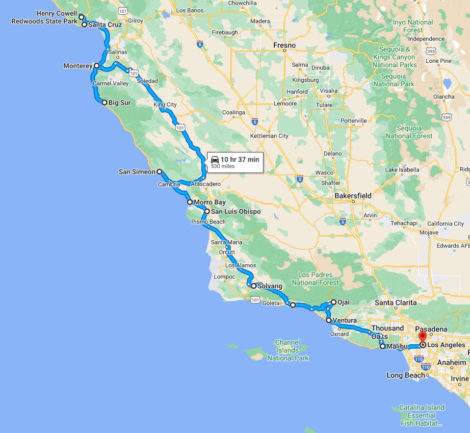
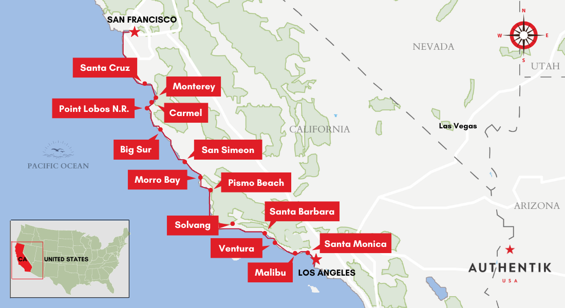
The classic California road trip often involves the Pacific Coast Highway (PCH), also known as Highway 1, a legendary route renowned for its breathtaking ocean vistas. While incredibly scenic, this path is significantly longer and more time-consuming than the most direct inland routes.
-
Highway 1 (Pacific Coast Highway): This route can stretch to over 500 miles (805 kilometers), depending on the exact starting and ending points within each city and the specific segments of Highway 1 chosen. The allure of this drive lies not in speed but in the experience. It winds through charming coastal towns like Monterey, Carmel-by-the-Sea, Big Sur (famous for its dramatic cliffs and Bixby Creek Bridge), and Santa Barbara. Travel time can easily range from 10 to 12 hours of pure driving, without factoring in stops for sightseeing, meals, or overnight stays. Many travelers opt to break this journey over two or three days to fully appreciate the stunning landscapes and attractions along the way.
-
Interstate 5 (I-5) – The Inland Route: For those prioritizing speed and efficiency, Interstate 5 (I-5) is the most direct and common driving route. This highway cuts through the Central Valley of California, offering a more utilitarian, though less visually spectacular, path. The distance along I-5 is approximately 380 miles (612 kilometers). The estimated driving time without significant traffic or stops is typically 5 to 6 hours. This route is popular for business travelers or those on a tight schedule, but it lacks the iconic vistas that define the coastal drive. It passes through agricultural heartlands and is often characterized by long stretches of highway dotted with service stations and fast-food restaurants.
-
Highway 101 (US-101): A compromise between the scenic PCH and the direct I-5, US-101 offers a blend of coastal glimpses and more direct travel. It runs north-south along the coast for much of its length, but it also deviates inland in various sections. The distance via US-101 is generally around 440 miles (708 kilometers). Driving time is typically between 7 and 8 hours, again, not including stops. This route allows travelers to experience some coastal beauty while remaining more time-efficient than Highway 1. It passes through cities like San Jose, Santa Barbara, and directly into Los Angeles.
Flying Distance and Time: The Swiftest Passage
For the ultimate in speed, flying between San Francisco and Los Angeles is the preferred method for many. The actual flight distance is the shortest, mirroring the aerial measurement of approximately 380 miles (612 kilometers).
-
Flight Time: The in-air time for a direct flight is remarkably short, usually around 1 hour and 15 minutes to 1 hour and 30 minutes. This brevity makes it an appealing option for short business trips or quick weekend getaways.
-
Total Travel Time: It is crucial to factor in the “total travel time” when considering flying. This includes travel to and from airports (San Francisco International Airport – SFO, Oakland International Airport – OAK, or San Jose International Airport – SJC on the San Francisco side, and Los Angeles International Airport – LAX, Hollywood Burbank Airport – BUR, or Long Beach Airport – LGB on the Los Angeles side), check-in procedures, security screening, boarding, and deplaning. When all these elements are accounted for, the total door-to-door travel time for a flight can often rival, and sometimes exceed, the driving time via I-5.
Other Modes of Transportation: Trains and Buses
While less common for this particular route, trains and buses also offer ways to travel between San Francisco and Los Angeles.
-
Amtrak Train: The Amtrak route, often involving the Coast Starlight train, provides a more relaxed way to travel, allowing passengers to enjoy the scenery without the stress of driving. The train journey typically takes around 9 to 11 hours, depending on the specific service and route. While longer than driving I-5, it offers a comfortable experience with amenities like dining cars and sleeper accommodations for overnight journeys. The rail lines often follow a coastal path for parts of the journey, offering picturesque views, though not as consistently as Highway 1.
-
Bus Services: Various bus companies, such as Greyhound or FlixBus, operate routes between the two cities. These are generally the most budget-friendly options. Travel times for buses can vary significantly, often ranging from 7 to 10 hours, influenced by traffic conditions and the number of stops made.
Factors Influencing Travel Time and Distance
Beyond the raw mileage, several critical factors can dramatically alter your perception of distance and the time it takes to traverse it.
Traffic Conditions
Both San Francisco and Los Angeles are notorious for their traffic congestion.
- Entering and Exiting Major Cities: The most significant delays typically occur when navigating through the urban sprawl of each metropolitan area. Rush hour can add hours to an otherwise manageable drive. Planning to depart or arrive outside of peak commuting times (typically 6-9 AM and 4-7 PM on weekdays) is highly recommended.
- Central Valley Congestion: Even on I-5, occasional slowdowns can occur due to truck traffic or temporary construction.
Road Conditions and Closures
The beauty of California’s highways, particularly Highway 1, can sometimes be marred by environmental factors.
- Highway 1: This route is particularly susceptible to landslides, especially during the rainy season (winter months). Sections of Highway 1 can be closed for extended periods, requiring detours onto Highway 101 or I-5. Checking current road conditions via the California Department of Transportation (Caltrans) website or app is essential before embarking on a coastal drive.
- Weather: Fog is common along the coast, especially in summer, which can reduce visibility and slow down driving. Extreme weather events, though less frequent, can also impact road conditions across the state.
Stops and Sightseeing
The choice of route directly dictates the potential for sightseeing.
- Highway 1: This route is designed for exploration. Popular stops include the Monterey Bay Aquarium, the historic missions, the stunning coastal vistas of Big Sur, and the charming shops and restaurants of Carmel-by-the-Sea. A leisurely pace is recommended to truly experience the PCH.
- I-5: This route is primarily about transit. While there are occasional rest stops and roadside attractions, it’s generally not chosen for its scenic or experiential value. Stops are usually for refueling, meals, or quick breaks.
Planning Your Journey: Choosing the Right Route
The distance between San Francisco and Los Angeles is not a fixed point but a variable influenced by your travel priorities.
For the Scenery Enthusiast: Embrace Highway 1
If your goal is to experience the quintessential California coastal drive, dedicate at least two to three days to travel via Highway 1. This allows ample time to explore the quaint towns, breathtaking viewpoints, and natural wonders. Lodging options range from intimate bed and breakfasts in Carmel to luxury resorts in Big Sur. Remember to book accommodations in advance, especially during peak season.
For the Time-Conscious Traveler: Opt for I-5
For those who need to get from point A to point B as efficiently as possible, I-5 is the clear choice. This route minimizes driving time, allowing for a quick transition between the two major Californian metropolises. Consider breaking up the drive with a stop in a Central Valley city like Bakersfield if needed, but be prepared for a less visually engaging journey.
For a Balanced Experience: Consider Highway 101
If you want a taste of the coast without the time commitment of Highway 1, US-101 offers a good compromise. It allows for detours to charming coastal communities like San Luis Obispo and Santa Barbara while remaining more direct than the full PCH experience.

The Swift Option: Flying
When time is of the essence and budget allows, flying is the quickest way to cover the distance. Remember to factor in the total travel time from your origin to your final destination at the other end, including airport transfers and waiting times.
Ultimately, the question of “how far” is intrinsically linked to “how you travel.” By understanding the different routes, their distances, and the factors that influence travel time, you can craft a journey that perfectly suits your needs and maximizes your experience between San Francisco and Los Angeles.
LifeOutOfTheBox is a participant in the Amazon Services LLC Associates Program, an affiliate advertising program designed to provide a means for sites to earn advertising fees by advertising and linking to Amazon.com. Amazon, the Amazon logo, AmazonSupply, and the AmazonSupply logo are trademarks of Amazon.com, Inc. or its affiliates. As an Amazon Associate we earn affiliate commissions from qualifying purchases.