
The Mississippi River, a titan of North America, is not merely a geographical feature; it is a ribbon of history, a cradle of culture, and a vital artery for commerce and life. Its immense length has captivated imaginations for centuries, prompting a fundamental question: how long is this legendary waterway in miles? While a precise, immutable number can be elusive due to the river’s dynamic nature, its generally accepted length offers a profound understanding of its scale and significance.
The Ever-Shifting Measurement of a Mighty River
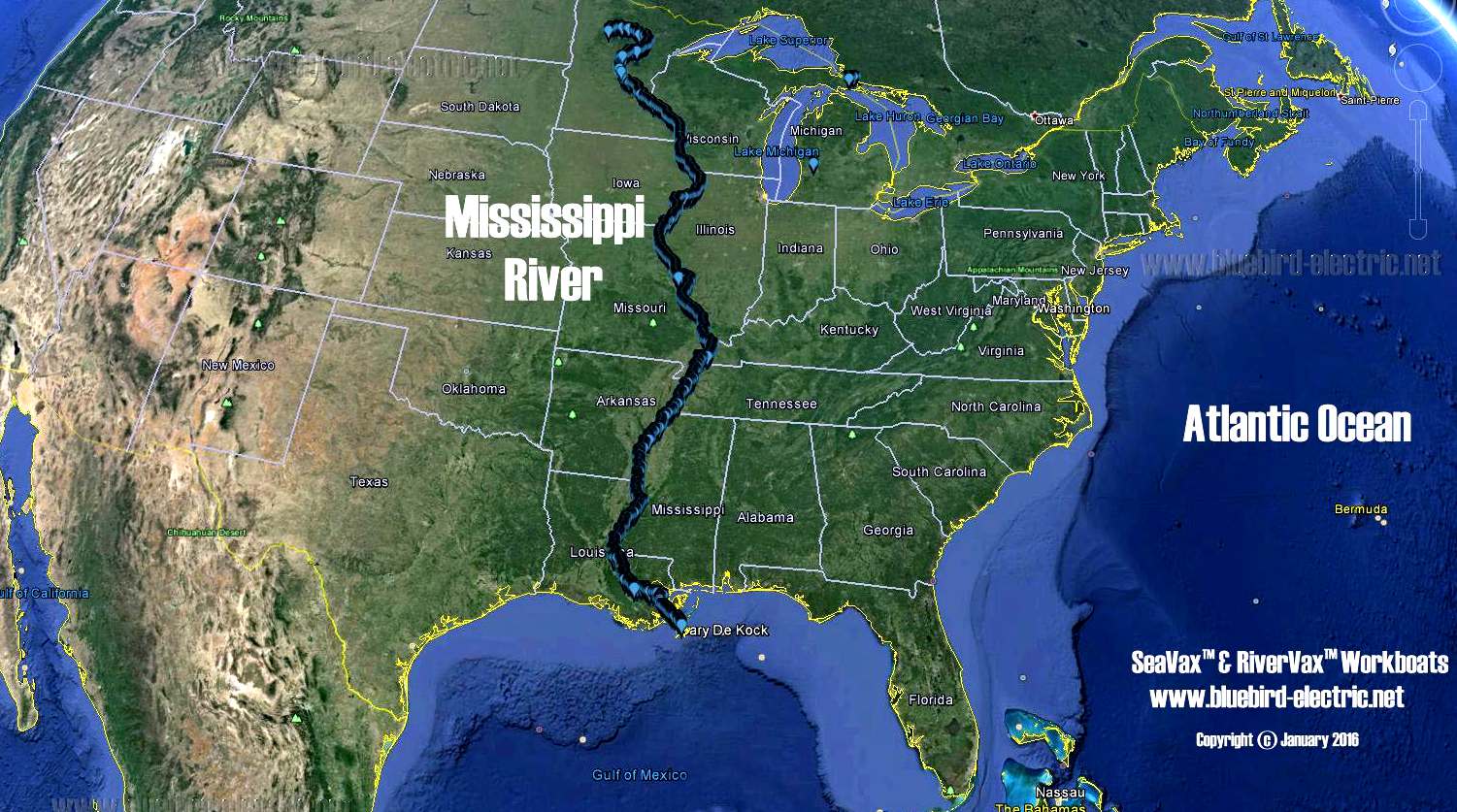
Measuring the exact length of a river like the Mississippi River is a task fraught with complexity. Rivers are not static entities; their courses evolve over time. Meanders shift, tributaries change their course, and deposition and erosion constantly alter the riverbed. The starting point and ending point also influence the final measurement. For the Mississippi, its journey begins in the serene confines of Lake Itasca in northern Minnesota and culminates in the vast expanse of the Gulf of Mexico.

The Official Length: A Benchmark of Grandeur
The United States Geologic Survey (USGS), the authoritative body for mapping and geological data in the United States, provides the most commonly cited length for the Mississippi River. This figure stands at approximately 2,320 miles. This measurement is a result of extensive surveying and cartographic efforts that have taken place over many decades. It represents the centerline of the river’s main channel, acknowledging the natural variations and sinuosities that define its path.
However, it’s crucial to understand that this is not a fixed, absolute number. The USGS itself acknowledges that the river’s length can fluctuate. Historical measurements have varied, and ongoing processes continue to reshape its course. This approximate length, however, serves as an invaluable benchmark, allowing us to comprehend the sheer geographical dominance of the Mississippi River within the North American continent.
Factors Influencing River Length Measurement
Several factors contribute to the variations in reported river lengths:
- Meanders: The sinuous, winding path of a river is a primary determinant of its length. A mile measured along the curves of a river is significantly longer than a straight-line mile. The Mississippi River is renowned for its extensive meanders, particularly in its lower reaches, which add considerably to its total mileage.
- Tributaries: While the primary length refers to the main stem, the inclusion or exclusion of significant meanders or oxbow lakes formed by the river can also subtly alter the perceived length.
- Measurement Techniques: Advances in technology, from traditional surveying to satellite imagery and GPS, have improved accuracy but also can lead to slight discrepancies in measurements taken at different times or with different methodologies.
- Defining the Source and Mouth: Pinpointing the precise starting point in the vastness of Lake Itasca and the exact termination point where the river meets the Gulf of Mexico can also introduce minor variations.
The Mississippi River is part of a larger river system, the Mississippi-Missouri-Jefferson River System. When measured as a single, continuous flow, this system is the fourth-longest in the world and the longest in North America, stretching an impressive approximately 3,902 miles. This highlights how the Mississippi’s identity is intertwined with its major tributaries, creating a vast hydrological network.
The Mississippi River: A Journey Through America’s Heart
The 2,320-mile journey of the Mississippi River is more than just a geographical traversal; it’s a passage through the very soul of the United States. From its humble beginnings as a clear, cool stream in the northwoods of Minnesota, it gradually swells, gathering strength and volume from countless tributaries as it flows southward, carving a path through diverse landscapes and leaving an indelible mark on the communities it nourishes.
The Upper Mississippi: Lakes and Loess Hills
The upper reaches of the Mississippi River are characterized by a more tranquil and picturesque setting. Flowing from Lake Itasca, it meanders through a region of forests and lakes, including the famous “Headwaters” where visitors can literally walk across the nascent river. As it progresses south, it encounters the dramatic bluffs and valleys of the Driftless Area, a region spared from glaciation. Cities like Minneapolis and St. Paul (the “Twin Cities”) owe their existence and growth to the river’s early navigational potential. Further downstream, cities like Dubuque and Davenport in Iowa, and Rock Island and Moline in Illinois (the “Quad Cities”) have long been shaped by its presence, serving as important ports and industrial centers. The locks and dams managed by the U.S. Army Corps of Engineers play a critical role in maintaining navigability along this stretch.
The Middle Mississippi: Gateway to the Heartland
As the Mississippi River flows into the central part of the country, its character shifts. It widens, carrying a greater volume of water and becoming a more significant artery for barge traffic. This section is often referred to as the Middle Mississippi. Here, the river forms the border between Iowa and Illinois, and later between Missouri and Illinois. The mighty Missouri River, North America’s longest river, joins the Mississippi near St. Louis, Missouri. This confluence dramatically increases the Mississippi’s flow and sediment load, giving it a muddy, powerful appearance. St. Louis itself is an iconic city on the river, famously marked by the Gateway Arch, a monument symbolizing westward expansion. The fertile floodplains along this stretch have long been a cornerstone of American agriculture.
The Lower Mississippi: Deltaic Majesty and the Gulf
The final thousand miles of the Mississippi River represent its most dramatic and dynamic phase. As it enters the southern states, the river widens considerably, its flow slows, and it begins to deposit the vast quantities of sediment it has carried from the interior of the continent. This process has created the immense and fertile Mississippi River Delta, a complex network of channels, bayous, and wetlands that eventually spills into the Gulf of Mexico. Major cities like Memphis, Tennessee, and New Orleans, Louisiana, are inextricably linked to the river. New Orleans, in particular, is a city built on the river’s edge, shaped by its floods, its commerce, and its unique culture. The engineering marvels of the Mississippi River Control System, including levees and spillways, are essential for managing the river’s immense power and protecting these low-lying communities. The river’s mouth is a vast, complex system where freshwater meets saltwater, creating a rich ecosystem that supports diverse wildlife.
The Mississippi River: A Lifeline for Exploration and Commerce
Understanding the length of the Mississippi River is not merely an academic exercise; it underscores its profound impact on exploration, transportation, and the very fabric of American development. For centuries, this magnificent waterway has served as a primary conduit, connecting regions and peoples, shaping economies, and influencing the nation’s destiny.
A Highway of Exploration and Settlement
From the earliest days of European exploration, the Mississippi River was recognized as a strategic pathway. Explorers like Hernando de Soto in the 16th century and later the Lewis and Clark Expedition in the early 19th century utilized its waters to venture into the vast interior of the continent. The river provided a natural highway for settlement, allowing pioneers to transport their goods and families westward and southward. Towns and cities sprang up along its banks, serving as vital outposts and trade centers. The accessibility offered by the Mississippi River was a critical factor in the westward expansion of the United States, transforming a sparsely populated frontier into a burgeoning nation.
The Backbone of American Commerce
In the modern era, the Mississippi River continues to be a vital commercial artery. As the nation’s primary inland waterway, it carries an enormous volume of goods, from agricultural products like grain and soybeans to coal, petroleum, and manufactured goods. The extensive system of locks and dams, particularly on the Upper Mississippi, ensures navigability for barges, which can transport freight far more efficiently and cost-effectively than by rail or truck. Ports along the river, such as those in New Orleans, Baton Rouge, and the Port of St. Louis, are critical hubs in the national and international supply chain. The 2,320 miles of navigable water represent a significant economic asset, facilitating trade and supporting countless jobs.

A Canvas for Culture and Identity
The sheer scale of the Mississippi River has also woven it into the cultural tapestry of the United States. It has inspired countless works of literature, music, and art. The steamboat era, immortalized in stories and songs, relied heavily on the river’s vastness. The river’s influence can be seen in the development of American music, particularly blues and jazz, which have deep roots in the communities along its lower reaches. The river’s flow, its power, and its ability to connect disparate regions have become potent symbols in the American imagination, representing journeys, transformation, and the very essence of the nation’s heartland. Understanding its length is to appreciate the scale of its historical and ongoing influence.
LifeOutOfTheBox is a participant in the Amazon Services LLC Associates Program, an affiliate advertising program designed to provide a means for sites to earn advertising fees by advertising and linking to Amazon.com. Amazon, the Amazon logo, AmazonSupply, and the AmazonSupply logo are trademarks of Amazon.com, Inc. or its affiliates. As an Amazon Associate we earn affiliate commissions from qualifying purchases.