
Crater Lake in Oregon stands as a profound testament to the raw, transformative power of geological forces. Known for its astonishing clarity and deep blue hue, this pristine body of water is not merely a lake but the caldera of an ancient volcano, sculpted by millennia of seismic activity, explosive eruptions, and the relentless work of nature. Its formation is a dramatic saga spanning hundreds of thousands of years, culminating in a cataclysmic event that forever altered the landscape of the Pacific Northwest. Understanding how this iconic landmark came into being offers not only a glimpse into Earth’s dynamic past but also deepens appreciation for its unique ecological and geological significance.
The Ancestral Volcano: The Rise of Mount Mazama
The story of Crater Lake begins long before the lake itself existed, rooted in the fiery depths beneath the Earth’s surface. For hundreds of thousands of years, the subduction of the Juan de Fuca Plate beneath the North American Plate fueled a chain of volcanoes known as the Cascade Range. Within this dynamic volcanic arc, a colossal stratovolcano began to grow, eventually reaching an estimated height of 12,000 feet (3,700 meters) above sea level. This magnificent peak was Mount Mazama.
A Precursor of Fire and Ice
Mount Mazama was not born in a single event but grew through countless eruptions over a period of approximately 400,000 years. During its lifespan, it exhibited a pattern of both effusive (lava flows) and explosive (ash and pyroclastic flows) eruptions, gradually building its conical shape. The region was also heavily glaciated, with massive ice sheets and glaciers carving deep U-shaped valleys into the volcano’s flanks, leaving behind telltale signs of their presence in the form of glacial striations and moraines. These glaciers interacted with volcanic activity, sometimes producing lahars (volcanic mudflows) as hot ash and rock melted the ice. The interplay of fire and ice was a defining characteristic of Mount Mazama’s formative years, shaping the rugged topography that surrounded its summit. The volcano was an imposing feature, dominating the skyline and acting as a central point of geological activity in the southern Oregon Cascades.
The Magma Chamber’s Expanding Pressure
Beneath Mount Mazama lay a vast and interconnected system of magma chambers. Over millennia, these chambers continuously filled with molten rock, superheated gases, and dissolved volatiles. As new magma rose from the mantle, it exerted immense pressure on the overlying crust. While many smaller eruptions relieved some of this pressure, the sheer volume of magma accumulating suggested that a much larger, more violent event was brewing. The composition of the magma, rich in silica and gases, was conducive to explosive eruptions, setting the stage for the dramatic climax that would define the region for eternity. The eventual release of this pressure would be unlike anything seen in the region for thousands of years, leaving an indelible mark on the planet.
The Cataclysm: The Eruption and Collapse of Mount Mazama
The pivotal event in Crater Lake’s formation occurred approximately 7,700 years ago (around 5,700 BC). After a period of relative dormancy, Mount Mazama unleashed a series of powerful eruptions that dwarfed anything seen before. This wasn’t a single blast, but a climactic sequence that fundamentally reshaped the mountain and its surroundings.
The Pumice Falls and Pyroclastic Flows
The eruption began with a massive Plinian column, thrusting a staggering volume of ash, pumice, and gas tens of miles into the atmosphere. Prevailing winds carried this volcanic debris eastward, blanketing vast areas of the Pacific Northwest in thick layers of pumice and ash. Geologists have found traces of Mount Mazama’s ejecta as far away as Canada and the central United States. This initial phase, known as the “Pumice Falls,” would have darkened the sky for days, making it the largest Holocene eruption in the Oregon Cascades.
Following the Plinian phase, the eruption transitioned to a more destructive stage: the generation of incandescent pyroclastic flows. These superheated currents of gas, ash, and rock fragments surged down the volcano’s slopes at incredible speeds, incinerating everything in their path. The immense volumes of material ejected from the magma chamber created a void beneath the mountain, removing structural support from the edifice above.
The Caldera Collapse
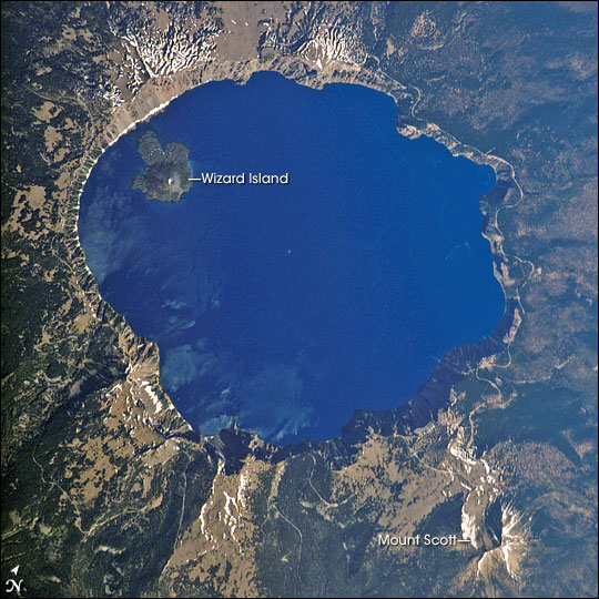
The evacuation of such a colossal volume of magma (estimates suggest around 12 to 14 cubic miles, or 50 to 60 cubic kilometers) from beneath the volcano had catastrophic consequences. With its internal support gone, the towering summit of Mount Mazama could no longer sustain itself. The overlying rock structure began to fracture and collapse inwards, not in a single, instantaneous event, but in a piecemeal fashion over hours or perhaps days. Great blocks of the mountain slid down into the evacuated magma chamber, creating a vast, bowl-shaped depression almost 6 miles (9.7 kilometers) in diameter and over a mile (1.6 kilometers) deep. This process is known as a caldera collapse. The Klamath Indians, whose ancestral lands encompassed the volcano, have oral traditions describing the cataclysm, speaking of a titanic battle between the chief of the Above-World, Skell, and the chief of the Below-World, Llao, that culminated in the destruction of Mount Mazama and the creation of Crater Lake.

The Birth of a Lake: Filling the Caldera
With the collapse of Mount Mazama, the dramatic caldera was formed, but it was still a desolate, volcanic basin. The next phase in the formation of Crater Lake involved the slow, persistent accumulation of water, transforming this raw geological scar into the serene blue gem we know today.
Centuries of Rain and Snowmelt
Immediately after the eruption and collapse, the caldera was a barren, hot, and geologically active landscape. However, the abundant precipitation characteristic of the Oregon Cascades—heavy snowfall in winter and significant rainfall throughout the year—began to collect in the deep depression. There are no inlets or outlets to the lake from rivers or streams; the water level is maintained solely by precipitation and groundwater. Over approximately 700 to 800 years, the caldera gradually filled with water, forming a lake that eventually reached its current depth. This process was likely interrupted by ongoing, smaller eruptions within the caldera itself, which created new volcanic cones.
The Unique Hydrology and Purity
The absence of incoming streams means that no sediment or pollutants are carried into the lake, contributing to its extraordinary clarity. Crater Lake is renowned for being one of the cleanest and clearest large bodies of water in the world, with visibility often exceeding 100 feet (30 meters). The deep blue color, a result of the lake’s incredible depth and the purity of its water, which scatters blue light more effectively than other colors, is truly mesmerizing. This unique hydrological system, relying entirely on precipitation and groundwater, is a critical factor in maintaining the lake’s pristine condition and contributes significantly to its status as a world-class natural landmark. The balance of inflow and evaporation ensures a relatively stable water level, a testament to the resilience and delicate equilibrium of nature.
Post-Caldera Features and Continuing Evolution
Even after the main caldera formed and the lake began to fill, volcanic activity wasn’t entirely over. The geological forces that created Mount Mazama continued to manifest, albeit on a much smaller scale, giving rise to some of the lake’s most distinctive features.
Wizard Island and the Phantom Ship
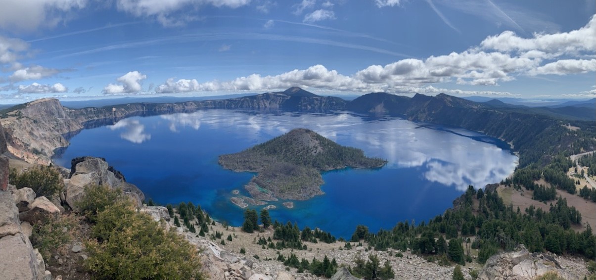
As the caldera began to fill with water, subsequent eruptions occurred from new vents on the caldera floor. The most prominent of these post-caldera volcanoes is Wizard Island. This cinder cone rises more than 750 feet (230 meters) above the lake’s surface, forming a picturesque island complete with its own small crater at its summit. Wizard Island is a prime example of continued volcanism after the main collapse, demonstrating that the magma chamber beneath the lake was not entirely depleted.
Another striking feature is the Phantom Ship, a small, jagged island near the southern shore. Composed of erosion-resistant volcanic dikes, it resembles a schooner under sail, especially in the mist or twilight. Both Wizard Island and the Phantom Ship are remnants of Mount Mazama’s complex volcanic history, standing as silent sentinels within the vast caldera.
Submerged Mysteries and Deep Blue Waters
The depths of Crater Lake hold numerous secrets. As the deepest lake in the United States, with a maximum depth of 1,943 feet (592 meters), its underwater landscape is as dramatic as its surface. Explorations using submersibles have revealed a diverse aquatic ecosystem, along with evidence of hydrothermal vents, suggesting residual heat and geological activity beneath the lake floor. These vents release warm water and minerals, influencing the lake’s chemistry and potentially supporting unique forms of life. The deep blue color, often described as sapphire or indigo, is a result of the lake’s exceptional depth and purity, allowing for the maximum absorption of all colors of the light spectrum except blue, which is scattered back to our eyes. This unparalleled clarity and depth make Crater Lake a natural marvel, continuously captivating scientists and visitors alike.
A Legacy of Geological Grandeur
Today, Crater Lake is the centerpiece of Crater Lake National Park, established in 1902 as the sixth national park in the United States. It serves as a living laboratory for geologists, hydrologists, and biologists, offering invaluable insights into volcanic processes, limnology, and ecological adaptation. The story of its formation—from the slow, majestic growth of Mount Mazama to its sudden, violent collapse and the gradual emergence of the lake—is a powerful reminder of Earth’s enduring capacity for creation and destruction. This geological masterpiece, born from fire and filled by the sky, remains one of the world’s most breathtaking and scientifically significant natural landmarks. Its stark beauty and dramatic origin continue to inspire awe, inviting all who visit to ponder the immense forces that shaped this unforgettable landscape.
LifeOutOfTheBox is a participant in the Amazon Services LLC Associates Program, an affiliate advertising program designed to provide a means for sites to earn advertising fees by advertising and linking to Amazon.com. Amazon, the Amazon logo, AmazonSupply, and the AmazonSupply logo are trademarks of Amazon.com, Inc. or its affiliates. As an Amazon Associate we earn affiliate commissions from qualifying purchases.