
Understanding Independence Pass: A Scenic Marvel
Independence Pass, carving a dramatic path through the heart of the Colorado Rockies, represents more than just a roadway; it is a quintessential high-alpine adventure, an iconic testament to the raw beauty and challenging terrain of the state. For many travelers, the allure of conquering this pass, one of the highest paved roads in North America, is an integral part of their Colorado experience. Connecting the historic mining town of Leadville and the Arkansas River Valley to the east with the glamorous resort town of Aspen and the Roaring Fork Valley to the west, Independence Pass offers an unparalleled journey across the Continental Divide at a breathtaking elevation of 12,100 feet.

This designated Colorado Scenic Byway is a highlight for anyone seeking dramatic mountain vistas, pristine alpine environments, and a sense of remoteness rarely found on major highways. Its history is as rich as its landscapes, originally serving as a crucial artery for miners and prospectors during the late 19th-century Colorado Gold Rush. Today, it continues to captivate modern adventurers with its challenging curves, steep ascents, and panoramic views that stretch across multiple mountain ranges.
The appeal of Independence Pass lies not just in its physical attributes but also in the unique experience it offers. Travelers traverse diverse ecosystems, from dense pine forests at lower elevations to the stark, yet beautiful, alpine tundra above the tree line. Wildflowers carpet the meadows in summer, while wildlife, including bighorn sheep and marmots, can often be spotted in their natural habitat. Despite its undeniable charm, the pass’s extreme elevation and exposure to the elements mean it is not accessible year-round, making its operational status a critical piece of information for any planned itinerary. Understanding when and how to experience Independence Pass is key to unlocking one of Colorado’s most unforgettable travel experiences.
The Annual Opening and Closing Cycle
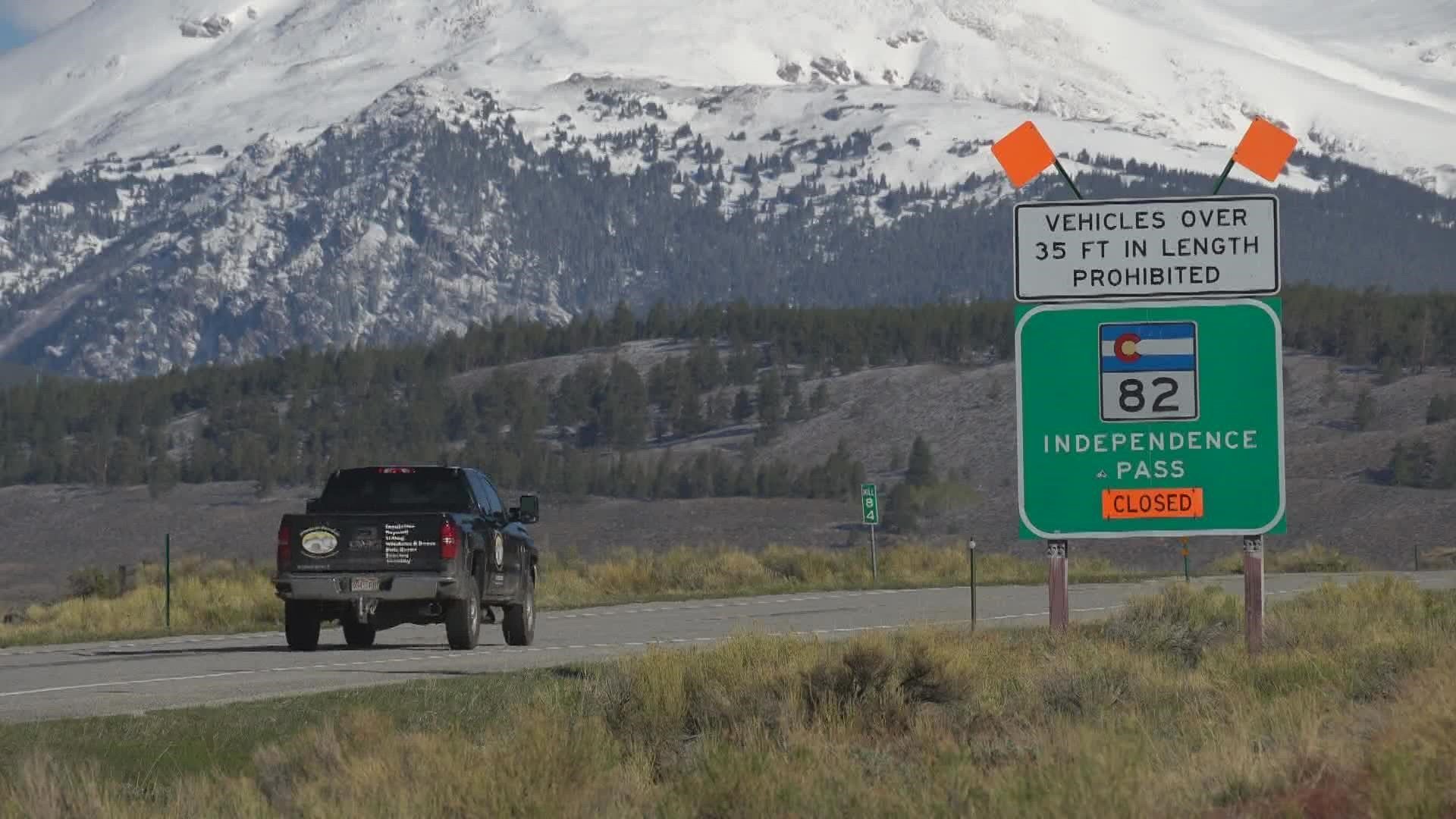
Unlike many of Colorado’s major mountain passes, Independence Pass is not a year-round route. Its extreme elevation and the prodigious snowfall it receives annually necessitate a seasonal closure, transforming it into a winter wonderland inaccessible to vehicles. The question of “Is Independence Pass open?” is therefore a seasonal query, central to planning any travel that involves this scenic route.
Typically, the pass opens for vehicular traffic in late May, often aiming for the Memorial Day weekend, and remains open until late October or early November, depending on the arrival of significant winter storms. This roughly five-month window, encompassing the peak summer and early fall seasons, is the only time travelers can drive its entirety. The specific opening and closing dates are fluid, dictated by a complex interplay of natural factors and the painstaking efforts of the Colorado Department of Transportation (CDOT).
Factors Affecting Opening Dates
The annual reopening of Independence Pass is a significant undertaking, and several critical factors influence when the gates can finally swing open:
- Winter Snowfall Amounts: The primary determinant is the sheer volume of snow accumulated over the winter months. Independence Pass can receive dozens of feet of snow, leading to drifts that are often 20 to 40 feet deep, and sometimes even higher, particularly on the eastern side where snow accumulation is more pronounced.
- Spring Thaw Conditions: The rate at which this massive snowpack melts is crucial. A slow, gradual thaw is ideal, reducing the risk of avalanches and flash flooding. However, a rapid warm-up can destabilize snowfields, creating hazardous conditions.
- Avalanche Danger: Even after the main road is cleared, the surrounding slopes pose a significant avalanche risk. CDOT crews must assess and mitigate these dangers, often requiring controlled blasting to bring down unstable snow before the pass can be deemed safe.
- Road Maintenance and Repair: The harsh winter environment takes a toll on the road surface. Crews must inspect the pavement for damage, repair potholes, clear debris, and address any rockfall issues that may have occurred during the freeze-thaw cycles. Guardrails and signage also require inspection and maintenance.
- Weather Forecasts: Even in late spring, sudden snowstorms can temporarily halt clearing efforts or even push back the anticipated opening date. CDOT closely monitors long-range forecasts to ensure that once opened, the pass can remain accessible for a reasonable period.
How to Check Current Status
Given the variability of opening and closing dates, checking the current status of Independence Pass before embarking on your journey is not just recommended, it is essential. Relying on official sources ensures the most accurate and up-to-date information:
- CDOT’s Official Website: The Colorado Department of Transportation maintains a comprehensive website, COtrip.org, which provides real-time information on road conditions, closures, and construction across the state, including Independence Pass. This should be your primary resource.
- Local Tourism Boards: The Aspen Chamber Resort Association, as well as tourism offices in nearby towns like Leadville and Twin Lakes, often have current information readily available on their websites or via phone.
- Social Media and News Outlets: CDOT frequently posts updates on its social media channels (e.g., Twitter, Facebook), and local news stations will report on the pass’s status, especially around the anticipated opening and closing times.
- Live Webcams: While not always available for every section, some webcams in the vicinity might offer a visual indication of snow levels and road conditions.
Always verify the information just prior to your departure, as conditions in the high country can change rapidly and unexpectedly, even in the summer months.
Navigating the Pass: What Travelers Need to Know
Driving Independence Pass is an experience unlike any other, offering unparalleled beauty and a true sense of adventure. However, it is imperative for travelers to understand the unique challenges and requirements of this high-alpine route to ensure a safe and enjoyable journey. This is not a typical highway; it demands respect and preparation.
The road itself, designated as Highway 82, is characterized by its narrow width, numerous sharp turns, and steep grades, particularly on the Aspen side. In many sections, there are no guardrails, and the drop-offs can be significant, adding to the dramatic nature of the drive. The highest sections traverse exposed alpine tundra, where trees are scarce, and the weather can shift dramatically without warning. Even on a clear summer day, temperatures can plummet, and sudden thunderstorms, hail, or even snow flurries are not uncommon.
Vehicle Restrictions and Safety

Due to its demanding nature, Independence Pass has specific restrictions and safety recommendations for drivers:
- Vehicle Length/Width Restrictions: Vehicles over 35 feet in length and/or 8 feet 6 inches in width are generally prohibited. This typically excludes large RVs, motorhomes, and vehicles pulling substantial trailers. The narrowness of the road, combined with tight switchbacks, makes it extremely difficult, if not impossible, for larger vehicles to safely navigate. Always check current CDOT regulations before attempting to cross with an oversized vehicle.
- Recommended Vehicle Types: Smaller vehicles, SUVs, and passenger cars are best suited for the pass. Four-wheel drive or all-wheel drive is not strictly necessary in summer conditions but can provide an added sense of security on gravel pull-offs or during unexpected weather.
- Driving Speed and Awareness: Adhere strictly to posted speed limits, which are often low (25 mph or less in many sections). Drive defensively, anticipate oncoming traffic around blind curves, and be prepared to use designated pull-outs to allow others to pass, particularly when going uphill or downhill.
- Emergency Preparedness: Cell service can be spotty or non-existent in many areas of the pass. It is wise to carry an emergency kit including extra water, snacks, a first-aid kit, blankets, and a full tank of gas. Ensure your vehicle is in good working order before starting the ascent.
- Altitude Sickness: The summit is at 12,100 feet. Be aware of the symptoms of altitude sickness (headache, nausea, dizziness) and take it easy at high elevations. Stay hydrated.
Essential Stops and Attractions Along the Way
The journey through Independence Pass is as much about the destinations along the way as it is about the drive itself. Several points of interest offer opportunities to stretch your legs, explore history, and soak in the natural grandeur:
- Independence Ghost Town: Located on the Aspen side of the pass, this preserved mining ghost town (Independence Ghost Town) offers a fascinating glimpse into Colorado’s pioneering past. Interpretive signs guide visitors through the remains of cabins and historical structures, painting a vivid picture of life at 10,900 feet during the late 1800s.
- Grottos Trail: Near the base of the pass on the Aspen side, the Grottos Trail is an easy, family-friendly hike. It features ice caves, a picturesque waterfall, and unique rock formations carved by the Roaring Fork River. It’s a great spot for a picnic or a short nature walk.
- Independence Pass Summit: The undisputed highlight of the drive is reaching the Independence Pass Summit. Here, at 12,100 feet, you stand on the Continental Divide, with breathtaking 360-degree views of the surrounding Elk Mountains and Sawatch Range. A short, paved path leads to an observation deck, and opportunities for further exploration on foot abound, offering truly unique photographic opportunities.
- Lost Man Loop Trailhead: For more avid hikers, the Lost Man Loop Trailhead, accessible from the pass, provides access to a stunning high-alpine wilderness area. This challenging but rewarding loop offers pristine lakes, wildflowers, and the chance to experience the solitude of the Colorado backcountry.
- Twin Lakes: On the eastern side, as you descend towards the Arkansas River Valley, the charming village of Twin Lakes offers beautiful views of two large glacial lakes nestled beneath towering peaks. It’s a serene spot for fishing, boating, or simply enjoying the tranquility of the mountain environment.
Each stop enriches the overall travel experience, providing context to the landscape and opportunities for immersion in Colorado’s natural and historical heritage.
Alternatives and Planning Your Trip
While Independence Pass offers an unparalleled scenic drive, its seasonal closure means that travelers must have alternative plans, especially if their itinerary falls outside the late May to early November window. Even during the open season, unexpected early or late snowstorms can temporarily close the pass, requiring flexibility in travel arrangements.
If Independence Pass is Closed: Alternative Routes
For travelers needing to journey between the Front Range (e.g., Denver) and Aspen when Independence Pass is closed, the primary and most reliable alternative is via Glenwood Canyon. This route involves:
- Taking Interstate 70 (I-70) west from the Front Range through Glenwood Canyon. While longer in distance, I-70 is a major highway that is generally maintained and open year-round, except during extreme weather events or rockslides.
- Exiting I-70 at Glenwood Springs and then heading south on Highway 82 directly to Aspen. This segment of Highway 82 is open year-round and offers a less dramatic but still scenic drive through the Roaring Fork Valley.
This alternative route adds approximately 1.5 to 2 hours to the travel time between Denver and Aspen, making it a roughly 3.5 to 4.5-hour journey, compared to the Independence Pass route which is closer to 2.5 to 3 hours under ideal conditions. Other lesser-known or gravel passes like Cottonwood Pass might offer seasonal alternatives, but their status should be meticulously checked as they also close for winter and may have different vehicle restrictions.
Tips for a Memorable Trip
To ensure your journey across Independence Pass is as enjoyable and safe as possible, consider these planning tips:
- Check Conditions Regularly: As reiterated, always check the pass’s current status via COtrip.org and local tourism resources right before you leave. Weather in the mountains is notoriously fickle.
- Pack Layers: Even on a warm summer day, temperatures at the summit can be significantly cooler, and winds can be strong. Bring warm layers, a hat, and gloves, especially if you plan to spend time hiking or exploring at high elevations.
- Stay Hydrated and Bring Snacks: High altitude can lead to dehydration. Carry plenty of water and some energy-rich snacks, especially since services are nonexistent along the pass itself.
- Fill Up Your Gas Tank: There are no gas stations on Independence Pass between Aspen and Twin Lakes. Ensure your vehicle has ample fuel before starting the ascent from either side.
- Charge Your Camera: The photo opportunities are endless, from sweeping vistas to delicate wildflowers. Don’t miss capturing the breathtaking beauty.
- Plan for Daylight Driving: It is highly advisable to drive the pass during daylight hours. The narrow, winding road, combined with potential wildlife crossings (deer, elk, bighorn sheep), makes night driving hazardous.
- Allow Ample Time: Don’t rush. The drive itself, with stops for photos, short hikes, and exploring sites like the Independence Ghost Town, can easily take a half-day or more. Rushing diminishes the experience and increases risk.
The Unforgettable Experience of Independence Pass
For many, the anticipation surrounding the opening of Independence Pass each spring is a clear indicator of the beginning of the Colorado high country travel season. Its seasonal nature only enhances its mystique, making the opportunity to drive it all the more special. This isn’t just a road; it’s a journey into the wild heart of the Rocky Mountains, offering an experience that transcends mere transportation.
The reason Independence Pass consistently ranks among the most coveted scenic drives in the United States lies in its unique blend of accessibility to extreme environments, historical significance, and sheer natural grandeur. Few other paved roads take travelers to such dizzying heights, through landscapes that range from dense evergreen forests to stark, yet vibrant, alpine tundra, all within a relatively short distance. The moment you crest the Continental Divide at 12,100 feet, surrounded by a panorama of jagged peaks and an endless sky, is truly unforgettable. It’s a moment that humbles, inspires, and connects you to the raw power and beauty of nature.
Beyond the views, the pass offers a sense of adventure. Navigating its tight switchbacks and steep inclines challenges drivers, rewarding them with a feeling of accomplishment. It encourages travelers to slow down, to pull over at designated overlooks, and to immerse themselves in the quiet majesty of the mountains. Whether you’re stopping to explore the remnants of the Independence Ghost Town, hiking a segment of the Lost Man Loop Trailhead, or simply breathing in the crisp, thin air at the summit, the pass provides a rich tapestry of experiences for every type of traveler.
This spectacular route stands as a testament to Colorado’s commitment to preserving its natural heritage while inviting visitors to partake in its splendor. For those seeking an authentic Colorado mountain experience—one that combines thrilling drives with breathtaking scenery, historical intrigue, and moments of serene solitude—Independence Pass remains a perennial highlight. Planning your trip with its seasonal opening in mind ensures you won’t miss out on one of North America’s truly iconic mountain drives.
LifeOutOfTheBox is a participant in the Amazon Services LLC Associates Program, an affiliate advertising program designed to provide a means for sites to earn advertising fees by advertising and linking to Amazon.com. Amazon, the Amazon logo, AmazonSupply, and the AmazonSupply logo are trademarks of Amazon.com, Inc. or its affiliates. As an Amazon Associate we earn affiliate commissions from qualifying purchases.