
The prospect of another hurricane threatening the Sunshine State is a recurring concern, particularly during the Atlantic hurricane season, which officially runs from June 1st to November 30th. For residents and tourists alike, understanding the current weather patterns, historical trends, and the proactive measures taken by organizations like the National Hurricane Center is crucial for preparedness and peace of mind. This article delves into the factors influencing hurricane development and the ongoing monitoring efforts that aim to provide timely warnings.
Understanding the Hurricane Season
The Atlantic hurricane season is a period of heightened tropical cyclone activity. While the season spans six months, the most active period typically occurs between mid-August and late October. Several environmental factors contribute to this heightened activity, including:

Key Meteorological Conditions
- Warm Ocean Waters: Hurricanes draw their energy from warm ocean surface temperatures. When waters reach or exceed 80°F (26.7°C), they can provide the necessary fuel for tropical disturbances to intensify into tropical depressions, then tropical storms, and ultimately hurricanes. The Gulf of Mexico and the western Atlantic are particularly prone to experiencing these warm conditions during the summer and fall months.
- Low Vertical Wind Shear: Wind shear refers to the change in wind speed and direction with height in the atmosphere. Low wind shear allows developing storm systems to organize and strengthen vertically. High wind shear can tear apart developing storms.
- Moist Mid-Atmospheric Air: A moist atmosphere in the mid-levels is essential for the development and sustenance of thunderstorms, which are the building blocks of hurricanes. Dry air can inhibit thunderstorm development and weaken existing storms.
- Atmospheric Instability: This occurs when rising air parcels are warmer than their surroundings, leading to continued ascent and the development of powerful thunderstorms.
- Pre-existing Weather Disturbances: Tropical waves, which are areas of low pressure that move from east to west across the tropics, often serve as the genesis for tropical cyclones. These disturbances can provide the initial spin and convergence needed for development.
Seasonal Forecasts and Influences
Meteorologists and climate scientists use various tools and indices to forecast the likelihood and intensity of hurricane seasons. These forecasts often consider:
- El Niño-Southern Oscillation (ENSO): This climate pattern, which includes phases like El Niño and La Niña, significantly influences Atlantic hurricane activity. Generally, La Niña conditions tend to suppress wind shear in the Atlantic, leading to a more active hurricane season. Conversely, El Niño conditions often increase wind shear, suppressing hurricane activity.
- Atlantic Multi-decadal Oscillation (AMO): This is a longer-term cycle of warming and cooling in the sea surface temperatures of the North Atlantic. Periods of warmer AMO are often associated with more active hurricane seasons.
- Saharan Air Layer (SAL): This is a mass of dry, dusty, and hot air that originates over the Sahara Desert and moves westward across the Atlantic. While it can sometimes suppress hurricane development due to its dry nature, it can also, in some instances, help to organize storm systems.
Monitoring and Warning Systems
The National Hurricane Center plays a pivotal role in tracking and forecasting tropical cyclones. Their sophisticated network of tools and constant vigilance ensures that timely and accurate information is disseminated to the public and emergency management agencies.
Tools and Technologies
- Satellites: Geostationary and polar-orbiting satellites provide continuous imagery of weather systems across the Atlantic basin. They allow meteorologists to observe cloud patterns, estimate storm intensity, and track the movement of tropical cyclones.
- Aircraft Reconnaissance: Specially equipped “hurricane hunter” aircraft from the U.S. Air Force Reserve and the National Oceanic and Atmospheric Administration (NOAA) fly directly into the eye of developing or existing tropical cyclones. They collect crucial data on wind speed, pressure, temperature, and humidity, which are vital for refining forecast models.
- Radar: Doppler radar systems, both land-based and airborne, can detect precipitation and wind patterns within storms, helping to assess their structure and intensity.
- Buoys and Weather Stations: A network of buoys and coastal weather stations provides real-time surface observations of wind, pressure, and sea level, offering valuable ground truth for forecasts.
- Computer Models: Advanced numerical weather prediction models run on supercomputers simulate atmospheric conditions and forecast the future track and intensity of tropical cyclones. Forecasters analyze the output from multiple models to develop the most likely scenario.
Alert and Advisory System

The National Hurricane Center issues various watches and warnings to alert the public and coastal communities to potential threats:
- Tropical Storm Watch: Issued when tropical storm conditions are possible in a specified area within 48 hours.
- Tropical Storm Warning: Issued when tropical storm conditions are expected in a specified area within 36 hours.
- Hurricane Watch: Issued when hurricane conditions are possible in a specified area within 48 hours.
- Hurricane Warning: Issued when hurricane conditions are expected in a specified area within 36 hours.
These alerts are critical for initiating preparedness measures, such as securing property, stocking emergency supplies, and planning evacuations if necessary. The lead time provided by these warnings allows individuals and communities to take appropriate actions to protect life and property.
Current Conditions and Forecasting for Florida
The question of “Is there another hurricane headed towards Florida?” requires a constant review of current atmospheric and oceanic conditions. This involves:
Monitoring Tropical Activity
Meteorologists at the National Hurricane Center meticulously monitor a vast expanse of the Atlantic Ocean, Caribbean Sea, and Gulf of Mexico for any signs of developing tropical disturbances. This includes:
- Investigating Areas of Interest: When weather patterns suggest the potential for storm formation, a specific “Invest” area is designated for close observation.
- Classifying Disturbances: As disturbances organize and strengthen, they are classified as tropical depressions, tropical storms (assigned a name when winds reach 39 mph), or hurricanes (winds of 74 mph or higher).
- Issuing Advisories: Regular public advisories are issued for any active tropical cyclones, detailing their current location, intensity, forecast track, and potential impacts.
Factors Affecting Florida’s Vulnerability
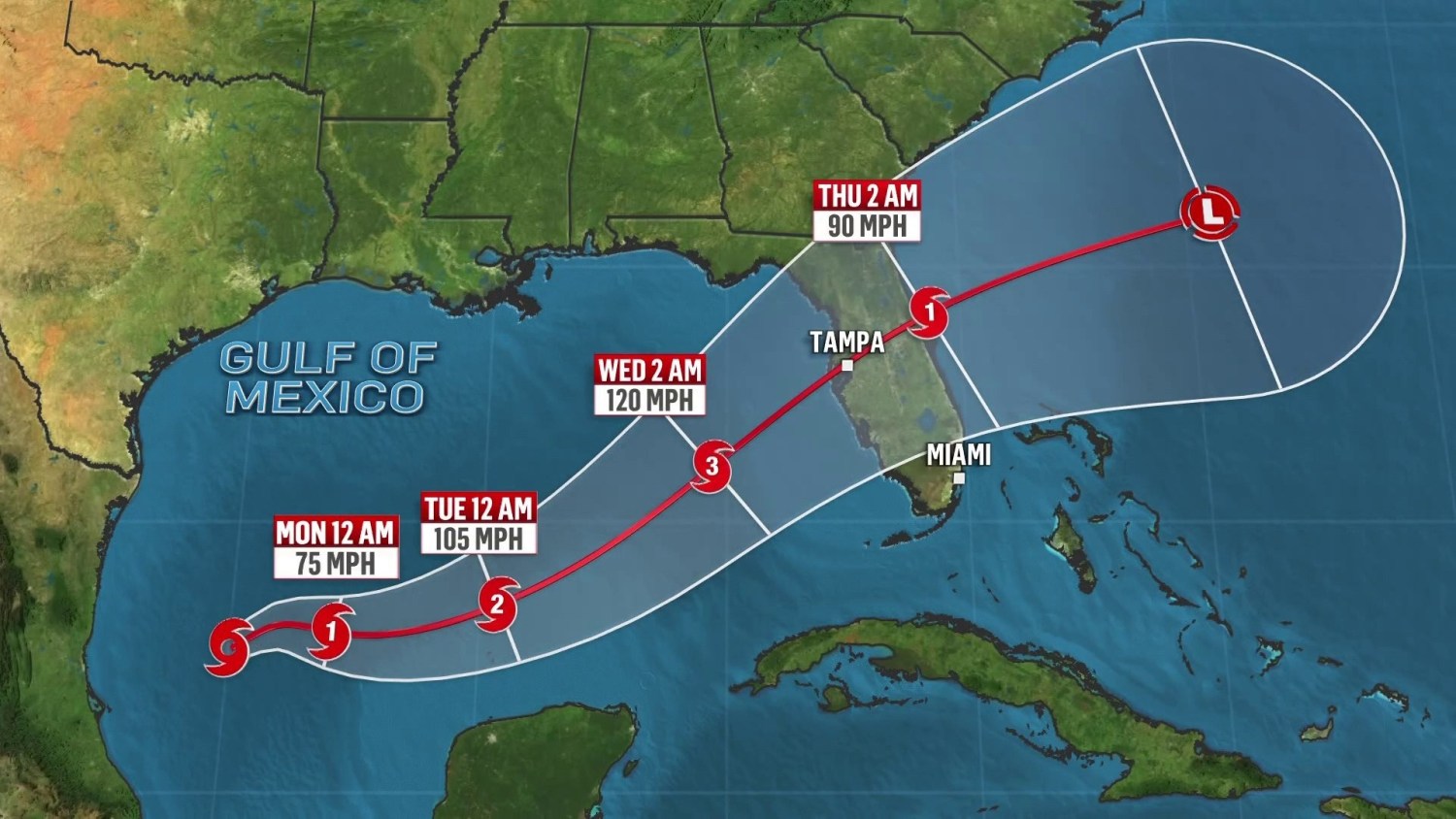
Florida’s unique geography, with its extensive coastline along the Atlantic Ocean and the Gulf of Mexico, makes it particularly susceptible to hurricanes. Several factors can influence whether a storm poses a direct threat to the state:
- Steering Currents: The large-scale atmospheric flow patterns, often referred to as steering currents, dictate the general movement of hurricanes. Ridges of high pressure and troughs of low pressure play significant roles in guiding storms. For instance, a strong ridge of high pressure over the Atlantic can steer storms westward towards Florida.
- Storm Intensity: The strength of a storm influences its potential impacts. Hurricanes can bring devastating winds, storm surge, and heavy rainfall.
- Landfall Location: Even a storm that stays offshore can have significant impacts on coastal areas through high winds, heavy rain, and rough surf. However, a direct landfall brings the most severe threats.
- Timing within the Season: While hurricanes can form at any point during the season, the peak activity period often sees a higher likelihood of storms developing and potentially impacting populated areas like Miami or the Florida Keys.
Staying Informed
For individuals in Florida, staying informed about potential threats is paramount. Reliable sources of information include:
- The National Hurricane Center: Their website (nhc.noaa.gov) is the official source for tropical cyclone forecasts and advisories.
- Local Emergency Management Agencies: These agencies provide state-specific and county-specific information on preparedness and evacuation orders.
- Reputable News Outlets: Local and national news organizations often provide comprehensive coverage of developing weather threats.
By understanding the science behind hurricane formation, the monitoring systems in place, and the specific vulnerabilities of the region, residents and visitors can be better prepared to face the challenges posed by the Atlantic hurricane season. Vigilance and preparedness are key to navigating these powerful natural events.
LifeOutOfTheBox is a participant in the Amazon Services LLC Associates Program, an affiliate advertising program designed to provide a means for sites to earn advertising fees by advertising and linking to Amazon.com. Amazon, the Amazon logo, AmazonSupply, and the AmazonSupply logo are trademarks of Amazon.com, Inc. or its affiliates. As an Amazon Associate we earn affiliate commissions from qualifying purchases.