
New York, a state synonymous with the iconic skyline of New York City and the breathtaking natural beauty of the Adirondack Mountains, is defined not only by its internal diversity but also by its distinct external boundaries. Understanding the border of New York is crucial for travelers seeking to explore its varied landscapes, for historians delving into its past, and for anyone curious about the geographical tapestry of the Northeastern United States. This exploration delves into the geographical, historical, and even cultural significance of New York’s borders, revealing a complex and fascinating story.
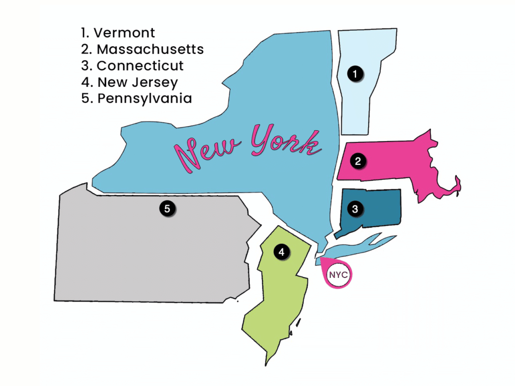
The Northern Frontier: Canada and the Great Lakes
New York’s northern border is perhaps its most expansive and geographically dramatic, shared with the nation of Canada. This frontier stretches for hundreds of miles, a significant portion of which is defined by the powerful waters of the St. Lawrence River and the magnificent Great Lakes.
The St. Lawrence River and the Thousand Islands
The St. Lawrence River forms a substantial part of the border between New York and the Canadian province of Ontario. This majestic river is not merely a boundary; it is a vital waterway and a region of unparalleled scenic beauty, particularly in the area known as the Thousand Islands. This archipelago, a collection of over 1,800 islands, bridges the United States and Canada, offering a unique landscape for boating, sightseeing, and exploring historic castles like Boldt Castle (though technically on the Canadian side, it’s a popular destination for New Yorkers). The international crossings here are well-established, facilitating easy travel and trade between the two nations.
Lake Ontario and Lake Erie
Further west, the border transitions to the vast expanse of two of the Great Lakes: Lake Ontario and Lake Erie. These freshwater seas serve as natural boundaries, with the international line running through their depths. For travelers, these lakes offer significant recreational opportunities, from sailing and fishing to visiting vibrant lakeside cities like Buffalo and Niagara Falls. The Niagara River, connecting Lake Erie to Lake Ontario, also forms a significant portion of this international boundary. The iconic Niagara Falls, a natural wonder straddling both New York and Ontario, is a prime example of how this border is not a barrier but a shared heritage.
The Eastern Expanse: Vermont and Massachusetts
To the east, New York shares its borders with two of its New England neighbors: Vermont and Massachusetts. These borders are predominantly terrestrial, characterized by rolling hills, dense forests, and historic towns that reflect a shared regional history.
The Green Mountain State: Vermont
The border with Vermont is largely defined by the New York-Vermont State Line Marker and the natural features that surround it, including the Hudson River watershed and parts of the Appalachian Mountains. This frontier is marked by a sense of pastoral tranquility, with numerous farms and small communities dotting the landscape. Travelers can easily traverse between the states, experiencing the distinct yet complementary cultures of New York and Vermont. Historic towns like Bennington in Vermont and Hoosick Falls in New York offer glimpses into the past and present of this border region.
The Bay State: Massachusetts
South of Vermont, New York’s eastern border is with Massachusetts. This boundary runs through a diverse landscape, encompassing rural areas, woodlands, and even some suburban fringes. The Berkshire Mountains influence the topography of this region, creating a scenic backdrop for exploration. Cities like Albany in New York and Pittsfield in Massachusetts serve as important cultural and economic hubs in proximity to this border. The interconnectedness of these areas fosters a rich exchange of arts, culture, and tourism.
The Southern Reaches: Pennsylvania and New Jersey
New York’s southern borders are with Pennsylvania and New Jersey, areas that are geographically distinct and historically significant, particularly in relation to the development of the nation.
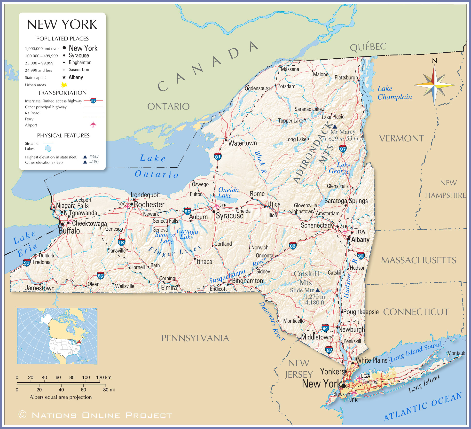
The Keystone State: Pennsylvania
The border with Pennsylvania is a long and varied one, extending from the Delaware River in the east to the shores of Lake Erie in the west. This frontier is characterized by a mix of agricultural lands, forests, and industrially historic regions. The section of the border near New York City is particularly dynamic, with major transportation arteries connecting the two states. Historically, the Mason-Dixon Line, though primarily associated with the boundary between Northern and Southern states, also played a role in the early delimitation of boundaries in this region. For travelers, crossing into Pennsylvania from New York can mean entering the rolling hills of the Poconos or the historic heartland of the Keystone State.
The Garden State: New Jersey
The border between New York and New Jersey is one of the most densely populated and economically vital land boundaries in the United States. This frontier is dominated by the presence of New York City and its extensive metropolitan area, which spills across the state line into Northern New Jersey. The Hudson River and the Arthur Kill and Kill Van Kull waterways define significant portions of this border. Bridges and tunnels are essential conduits for the daily commute of millions and for the flow of commerce. For tourists, the proximity of major attractions in both states, such as Liberty State Park in New Jersey offering views of the Statue of Liberty and the Manhattan skyline, highlights the interconnectedness of this region.
The Maritime Frontier: The Atlantic Ocean
While New York is primarily defined by its land borders, its eastern edge also fronts the vast expanse of the Atlantic Ocean. This maritime border is not a fixed line on land but rather the territorial waters extending from the coastline, marking New York’s interaction with the wider world.
The Coastline and Islands
New York’s Atlantic coastline stretches along its southeasternmost part, providing access to beaches, ports, and a connection to maritime trade and history. The barrier islands, such as Long Island, form a significant part of this coastal boundary, separating the bays and inlets from the open ocean. For travelers, destinations like the Hamptons and Fire Island are quintessential New York coastal experiences, offering a different pace of life from the bustling city. The maritime border also extends to the influence of global weather patterns and the rich marine ecosystems that contribute to the state’s natural heritage.
Historical Context and Significance
The borders of New York are not static lines drawn arbitrarily but are the result of centuries of negotiation, conflict, and settlement. From the original claims of European powers to the modern-day agreements with Canada, each boundary has a story to tell.
Colonial Claims and Surveyors
The early colonial period saw competing claims from the English, Dutch, and French, which led to complex and often contested territorial lines. The eventual establishment of New York as an English colony brought about a more defined structure. The surveys conducted by figures like Charles Mason and Jeremiah Dixon for the Pennsylvania border, for instance, were crucial in resolving disputes and solidifying boundaries that largely persist today.
Indigenous Territories and Treaties
It is also vital to acknowledge that the establishment of these borders often occurred over land that was originally the territory of various Indigenous peoples. Treaties and agreements, though often fraught with inequality, played a role in shaping the perceived boundaries and the eventual state lines. Understanding the historical context of Indigenous territories adds a layer of complexity and importance to the narrative of New York’s borders.

Modern Border Management
Today, the borders of New York are managed through international agreements with Canada and interstate compacts with its neighboring states. Agencies like Customs and Border Protection on the northern border and various state departments ensure the smooth flow of traffic, trade, and travel while maintaining security and enforcing regulations. For travelers, these borders are often points of passage, marked by welcome signs and ports of entry that signify a transition between jurisdictions, each with its own unique character and offerings. The intricate network of roads, rivers, and railways that cross these borders underscores their role not as barriers, but as connectors in the vast geographical and cultural landscape of North America.
LifeOutOfTheBox is a participant in the Amazon Services LLC Associates Program, an affiliate advertising program designed to provide a means for sites to earn advertising fees by advertising and linking to Amazon.com. Amazon, the Amazon logo, AmazonSupply, and the AmazonSupply logo are trademarks of Amazon.com, Inc. or its affiliates. As an Amazon Associate we earn affiliate commissions from qualifying purchases.