
Navigating the Geography of the City of Fountains
When planning an itinerary to explore the vibrant heart of the Midwest, understanding the layout of Kansas City is essential for any traveler. Unlike smaller municipalities that rely on a single postal code, this sprawling metropolis encompasses dozens of unique zones, each dictating a different neighborhood vibe, culinary scene, and architectural style. From the historic brick-paved streets of the Crossroads Arts District to the upscale Spanish-inspired courtyards of the Country Club Plaza, pinpointing the correct numerical designation ensures your GPS, rideshare app, and postal deliveries land precisely where intended.
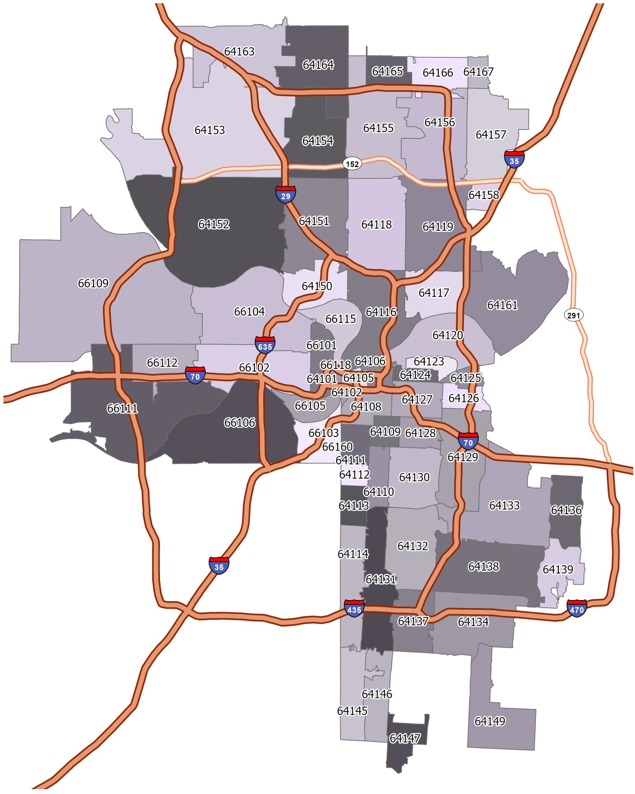
Why Postal Codes Matter for Travelers
For visitors navigating Missouri, acknowledging that the city sits directly on the state line adjacent to Kansas is the first hurdle. While both states feature urban areas bearing the same moniker, the Missouri side holds the historical core, iconic jazz heritage sites, and world-renowned barbecue institutions. Knowing the precise zone numbers—ranging from 64101 down through 641[xx] series—allows tourists to efficiently group their sightseeing activities, book accommodations in the most walkable districts, and avoid accidental border crossings into neighboring suburbs that might disrupt tightly planned daily schedules.
The Historic Core and Downtown Zones
At the center of urban revitalization lies the downtown sector, primarily operating under the 64105, 64106, and 64108 codes. This is where modern skyscrapers meet nineteenth-century architecture, anchored by landmarks like the Power and Light District and the monumental Union Station. Travelers frequenting this area will find themselves within walking distance of the National World War I Museum and Memorial, where soaring observation towers offer breathtaking panoramas of the entire region. The concentration of cultural attractions within these specific zones makes them the absolute epicenter for first-time visitors seeking an immersive metropolitan experience.
Exploring Neighborhood Districts by Postal Zone
The Artistic Pulse of 64108
Just south of the central business district, the 64108 zone encapsulates the creative soul of the region. This area covers the bustling Crossroads Arts District and parts of the historic Westside. Visitors wandering through these streets during the famous First Fridays art crawls will experience an explosion of local galleries, boutique coffee shops, and converted industrial warehouses turned into vibrant eateries. Navigating this zone reveals the grassroots artistic community that defines the contemporary cultural landscape of Kansas City.
Upscale Elegance in 64112

Moving further south brings travelers into the 64112 territory, home to the legendary Country Club Plaza. Designed in the 1920s and modeled after Seville, Spain, this open-air shopping and entertainment district features ornate Spanish architecture, winding creeks, and intricate tilework. Tourists staying or dining in this zone enjoy high-end retail options, picturesque walking paths, and proximity to the stunning greenery of Loose Park. It represents the sophisticated, leisurely side of Midwestern travel, attracting those who appreciate fine dining and picturesque outdoor strolls.
Cultural Enclaves and Culinary Hubs
Surrounding these primary districts are residential and commercial zones that harbor some of the region’s best-kept secrets. The 64111 and 64109 codes cover vibrant areas like Westport and the historic 18th & Vine Historic Jazz District.
- Westport: Known as the oldest established community in the area, offering a lively nightlife scene and historic markers.
- 18th & Vine: The sacred birthplace of jazz, housing the renowned American Jazz Museum and the Negro Leagues Baseball Museum.
Practical Travel Tips for Area Codes and Postal Zones
Avoiding Confusion with the State Line
One of the most common pitfalls for travelers is confusing the Missouri side with its sister city across the state line in Kansas. While they share a continuous metropolitan sprawl, their local governance, tax structures, and postal systems are entirely distinct. The Missouri side utilizes the 641xx prefix range, whereas the western counterpart uses 662xx series. Double-checking your destination’s exact street address and numerical zone before booking tours, rental cars, or reservations ensures seamless navigation.
Utilizing Digital Mapping Tools
Modern navigation applications rely heavily on precise postal data to route tourists efficiently through complex urban layouts. When typing destinations into mapping software, including the correct regional digits alongside street names prevents routing errors that could send you miles away from your intended landmark. Whether you are heading to catch a game at Kauffman Stadium or exploring the sprawling exhibits at the Nelson-Atkins Museum of Art, verifying the local zoning details guarantees a smooth and stress-free journey.
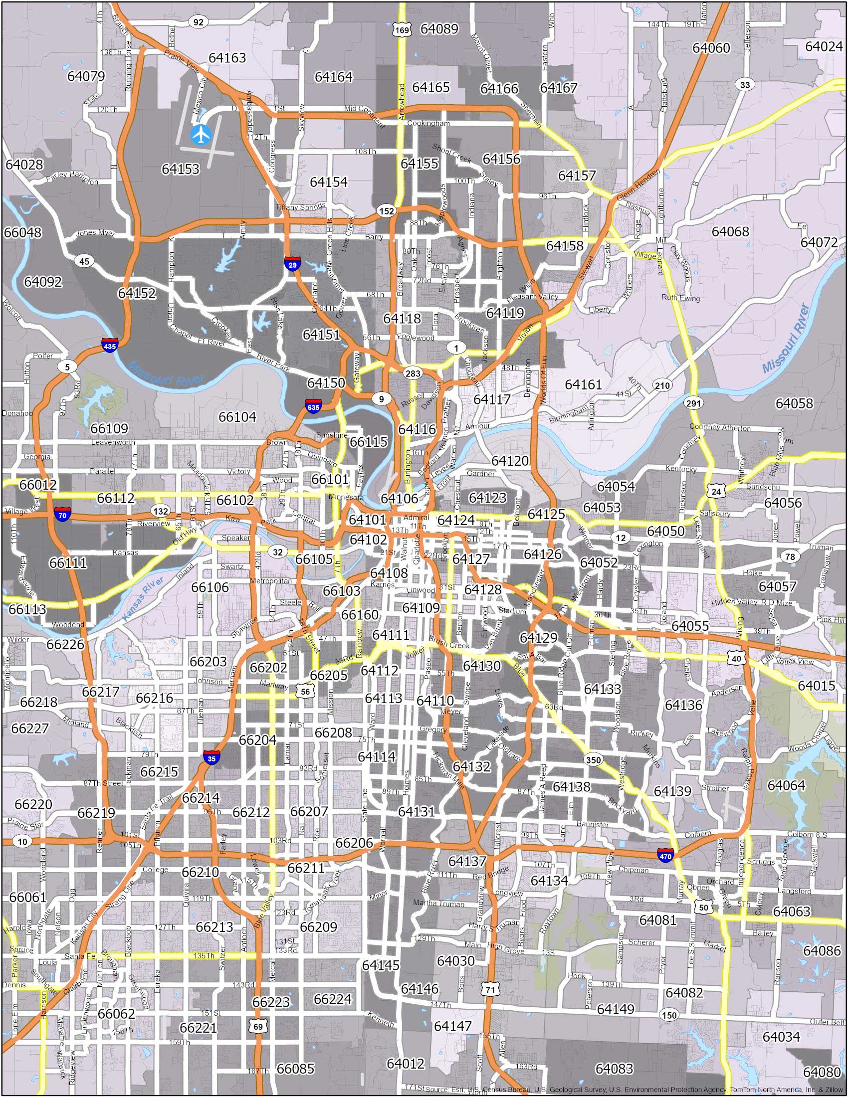
Summary of Regional Zones for Visitors
To help structure your upcoming travel itinerary, keeping a quick mental reference of the primary visitor districts and their corresponding numerical regions will streamline your adventure:
- Downtown / Financial District: 64105, 64106
- Crossroads / Westside: 64108
- Westport / Midtown: 64111
- Country Club Plaza / Brookside: 64112
- Historic Jazz District: 64108, 64127
Armed with this geographical knowledge, exploring the rich heritage, legendary cuisine, and stunning architecture of this Midwestern gem becomes an effortless and deeply rewarding travel experience.
LifeOutOfTheBox is a participant in the Amazon Services LLC Associates Program, an affiliate advertising program designed to provide a means for sites to earn advertising fees by advertising and linking to Amazon.com. Amazon, the Amazon logo, AmazonSupply, and the AmazonSupply logo are trademarks of Amazon.com, Inc. or its affiliates. As an Amazon Associate we earn affiliate commissions from qualifying purchases.