
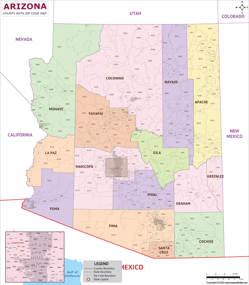
The question, “What is the zip code of Arizona?” is a fascinating one, not because there’s a singular answer, but because it illuminates the complex and varied postal landscape of a vast and diverse state. Unlike a small town or a specific building that might have one or two designated zip codes, a state as large as Arizona encompasses thousands of these five-digit numerical identifiers. Each zip code serves a specific geographic area, facilitating the efficient sorting and delivery of mail. Understanding the zip code system within Arizona is less about finding one magical number and more about appreciating the granular division of a sprawling territory.

The USPS and Zip Code Allocation
The United States Postal Service (USPS) established the Zone Improvement Plan (ZIP) code system in 1963 to improve the speed and accuracy of mail delivery. The system divides the United States into geographic areas, with each area assigned a unique five-digit code. The first digit generally represents a broad geographical region of the country, the next two digits narrow that down to a sectional center facility (SCF), and the final two digits designate a specific post office or delivery area within that SCF.
For a state as large and geographically varied as Arizona, this means a multitude of zip codes. These codes are not static; they can be created, modified, or retired by the USPS based on population density, changes in delivery routes, and the establishment of new postal facilities. Therefore, any attempt to pinpoint a single zip code for the entire state is fundamentally flawed. Instead, the postal landscape of Arizona is a mosaic of thousands of these codes, each serving a distinct purpose in the intricate logistics of mail delivery.
Understanding Zip Code Structure
The five-digit zip code structure can be broken down further to understand its geographical intent.
The First Digit: Broad Regionalization
In the case of Arizona, the first digit of its zip codes typically falls within the ‘8’ range. This signifies that Arizona is part of the Western United States region as defined by the USPS. This initial digit provides a high-level geographical grouping, allowing for the initial sorting of mail as it enters the national postal network.
The Second and Third Digits: Sectional Center Facilities (SCFs)
The subsequent two digits further refine the geographical area. These numbers often correspond to specific sectional center facilities (SCFs) – large mail processing plants that handle mail for a designated region. For Arizona, SCFs might be located in major metropolitan areas like Phoenix or Tucson, or in strategically important smaller cities. A zip code starting with ’85’ might indicate a facility serving the central part of the state, while ’86’ could point to the northern or western regions.
The Fourth and Fifth Digits: Specific Delivery Areas
The final two digits are the most granular, identifying a specific post office, a delivery district within a larger post office, or a particular route. This is where the true diversity of zip codes becomes apparent. A bustling urban neighborhood in Phoenix will have different zip codes than a remote rural community near the Grand Canyon, or a growing suburb in Scottsdale. These digits ensure that mail reaches its intended street address accurately and efficiently.
Zip Codes Across Arizona: A Diverse Landscape
Arizona’s expansive geography, from the urban sprawl of its major cities to the vast deserts and rugged mountains, necessitates a wide array of zip codes. Each region, and often each town or neighborhood within that region, is served by one or more unique zip codes.
Urban Centers: High Density, High Zip Code Count
The metropolitan areas of Arizona are the most densely populated and therefore have the highest concentration of zip codes.
- Phoenix Metropolitan Area: This sprawling urban center, including cities like Phoenix, Mesa, Chandler, Glendale, and Scottsdale, is a prime example. You’ll find zip codes ranging from the 850xx series for central Phoenix to 852xx and 853xx for its surrounding suburbs. These codes reflect the dense residential areas, commercial districts, industrial parks, and a multitude of businesses that define urban life.
- Tucson Metropolitan Area: Further south, Tucson and its surrounding communities also possess a comprehensive network of zip codes, predominantly in the 857xx range. Similar to Phoenix, these zip codes cater to residential neighborhoods, vibrant downtown areas, university campuses (like the University of Arizona), and significant business sectors.

Rural and Remote Areas: Broader Coverage, Fewer Codes
In contrast to the urban cores, the vast rural and less populated areas of Arizona will have fewer zip codes, and those that do exist may cover significantly larger geographical areas.
- Northern Arizona: Regions around Flagstaff, Prescott, and extending towards the Navajo Nation and the Grand Canyon, utilize zip codes that might serve entire counties or vast stretches of national forest and wilderness. For instance, areas around the Grand Canyon National Park would have specific codes for visitor centers and lodges, but the surrounding sparsely populated regions might share codes over many square miles. Zip codes in these areas might begin with ’86’ or ‘863’, covering diverse landscapes from pine forests to high desert plateaus.
- Southern and Western Arizona: The deserts of Yuma and the border regions also have their own unique set of zip codes, often in the 853xx or 856xx ranges. These areas, characterized by agriculture, military bases, and smaller border towns, have postal divisions that reflect their specific needs and population distribution.
How to Find a Specific Zip Code in Arizona
Given the multiplicity of zip codes, the practical question for anyone interacting with Arizona is not what is the zip code of Arizona, but rather, how to find a specific zip code for a particular location within the state. Fortunately, the USPS provides user-friendly tools for this purpose.
The USPS Zip Code Lookup Tool
The most reliable method is to utilize the official USPS Zip Code Lookup tool. This can be accessed through the USPS website and allows users to search by:
- Address: By entering a full street address, including city and state, the tool will return the correct zip code. This is the most precise method for finding a zip code for a specific mailing address.
- City and State: If you only know the city and state, you can enter this information to see a list of all zip codes associated with that city. This is useful for understanding the general postal zones of a particular town or city.
Other Online Resources
Beyond the official USPS tool, numerous third-party websites also offer zip code lookup services. While these can be convenient, it’s always best to cross-reference with the USPS data for accuracy, especially for critical mailings. These sites often aggregate zip code data and may provide additional information such as population statistics, demographics, or even local business listings associated with a zip code.
The Significance of Zip Codes Beyond Mail Delivery
While their primary function is mail sorting, zip codes have evolved to serve numerous other purposes, influencing everything from business operations to personal convenience.
Business and Logistics
Businesses rely heavily on zip codes for a multitude of operations:
- Shipping and Fulfillment: Accurate zip codes are crucial for calculating shipping costs, estimating delivery times, and managing logistics. Companies like Amazon use zip code data to optimize their distribution networks and ensure timely deliveries.
- Market Analysis and Targeting: Zip codes provide valuable geographical segmentation for marketing efforts. Businesses can analyze customer demographics and purchasing patterns by zip code to tailor their advertising campaigns and product offerings to specific areas within Arizona.
- Site Selection: For brick-and-mortar businesses, zip code analysis is vital for choosing optimal locations. Understanding the zip codes that surround a potential retail or service location helps assess the customer base and competitive landscape.
Personal Use and Convenience
Individuals also find zip codes useful in various aspects of their lives:
- Online Shopping: As mentioned, zip codes are essential for online purchases, influencing shipping costs and delivery speed.
- Identifying Local Services: When searching for local businesses, doctors, or schools, entering a zip code can help narrow down search results to your immediate vicinity.
- Community Identification: Zip codes can serve as a proxy for community identification. People often associate themselves with the zip code of their neighborhood, and it can be used in informal contexts to describe one’s location.
- Real Estate: Real estate websites and agents use zip codes extensively to categorize listings, compare property values, and understand neighborhood characteristics within Arizona.
In conclusion, the question “What is the zip code of Arizona?” is best answered by understanding that Arizona, like any large state, is comprised of a vast network of individual zip codes, each serving a specific purpose in the delivery of mail and influencing many other facets of modern life.
LifeOutOfTheBox is a participant in the Amazon Services LLC Associates Program, an affiliate advertising program designed to provide a means for sites to earn advertising fees by advertising and linking to Amazon.com. Amazon, the Amazon logo, AmazonSupply, and the AmazonSupply logo are trademarks of Amazon.com, Inc. or its affiliates. As an Amazon Associate we earn affiliate commissions from qualifying purchases.