
California, a state synonymous with sunshine, innovation, and breathtaking landscapes, also holds a powerful, underlying secret: its extensive network of geological fault lines. These fractures in the Earth’s crust are the very reason for the state’s dramatic topography and a constant reminder of the powerful forces shaping our planet. Understanding the location and behavior of these fault lines is crucial for anyone visiting or residing in the Golden State, offering a deeper appreciation for its natural wonders and a necessary awareness of its seismic activity.
Understanding California’s Geological Heartbeat
California sits astride the boundary between two major tectonic plates: the Pacific Plate and the North American Plate. This geological confluence is the primary driver behind the state’s dynamic seismicity. Unlike many regions where tectonic plates simply pull apart or collide head-on, California’s plate boundary is largely characterized by lateral movement, a process known as transform faulting. Imagine two giant puzzle pieces grinding past each other horizontally. This constant friction and occasional abrupt release of built-up stress are what generate earthquakes.
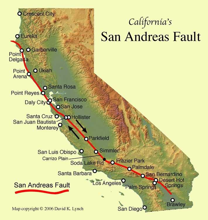
The San Andreas Fault is by far the most famous and significant of these boundary faults. It stretches for over 800 miles, snaking its way from near the Mexican border in the south to just north of San Francisco in the north. This massive fault is responsible for a significant portion of the relative motion between the Pacific and North American plates. Other major fault systems, often branching off or closely associated with the San Andreas, contribute to the complex seismic landscape of California. These include the Hayward Fault, the Garlock Fault, the Big Pine Fault, and the Owens Valley Fault, each with its own history of seismic events and potential for future activity.
The Anatomy of a Fault Line
A fault line is not a single, clean break in the Earth’s crust. Instead, it’s a zone of crushed and fractured rock. The movement along these faults can occur in several ways:
- Strike-Slip Faults: These are the most common type in California, characterized by horizontal movement. The San Andreas Fault is a prime example, with the Pacific Plate moving northwest relative to the North American Plate.
- Thrust Faults: Here, one block of rock is pushed up and over another, often associated with compressional forces.
- Normal Faults: These occur when rocks are pulled apart, causing one block to drop down relative to the other.
The movement along fault lines can be constant and gradual, a process called creep, or it can occur in sudden, violent slips, resulting in earthquakes. The accumulation of stress over time, followed by a rapid release, is the fundamental mechanism behind seismic events. The magnitude of an earthquake is determined by the amount of energy released, which is directly related to the extent and speed of the slip along the fault.
Mapping the Major Fault Zones
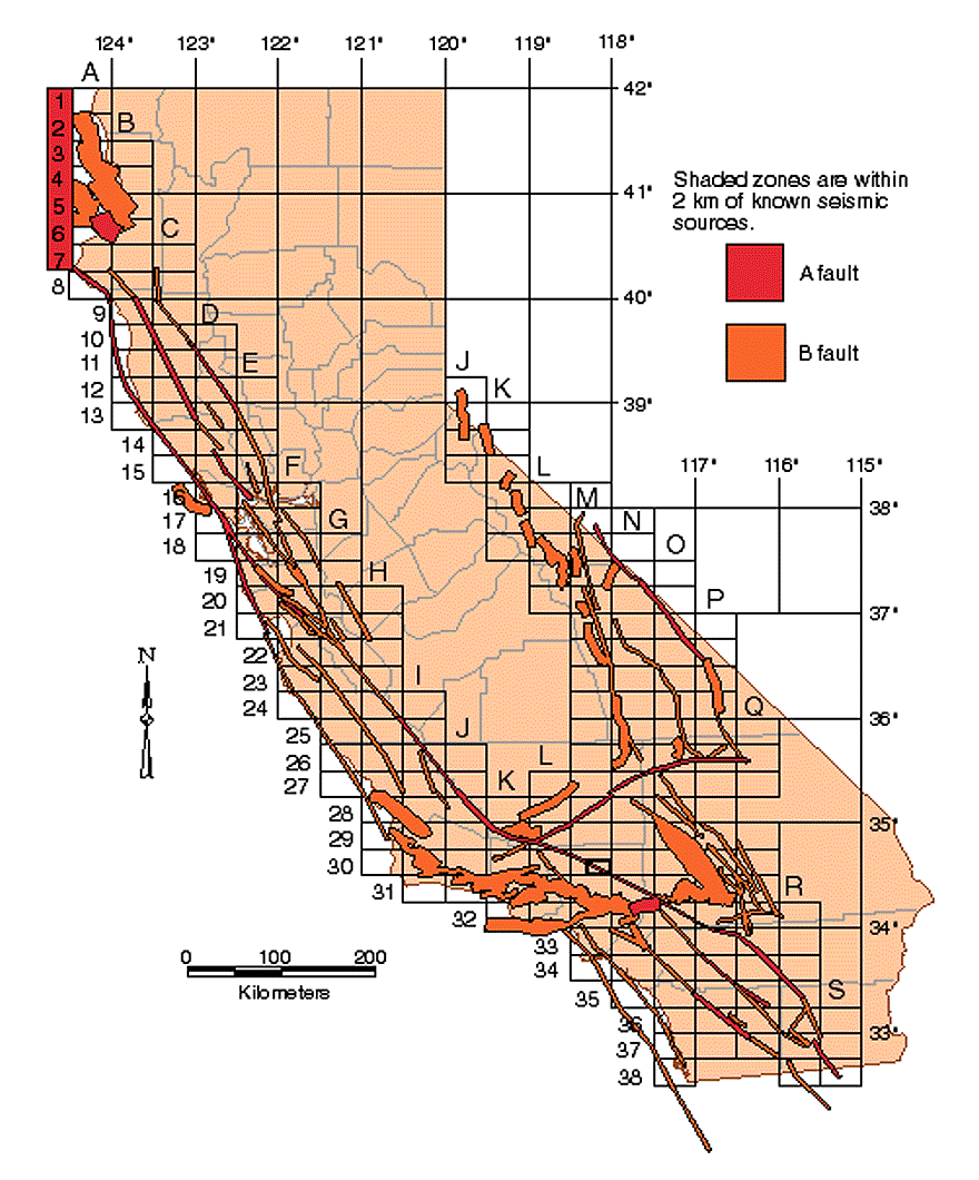
While the San Andreas Fault is the undisputed titan, California is crisscrossed by numerous other significant fault systems, each posing a unique geological narrative. Geologists have meticulously mapped these fault lines, allowing for a more informed understanding of seismic risk across the state.
The San Andreas Fault System
The San Andreas Fault is not a single, monolithic entity but a complex system of interconnected faults. It begins in Southern California, passing near communities like Palm Springs, San Bernardino, and running offshore before making landfall near Los Angeles. It then traverses through the San Francisco Bay Area, notably west of San Jose and through San Mateo and Marin counties. Iconic landscapes, such as the Carrizo Plain National Monument, showcase visible evidence of its immense power and long history.
The Hayward Fault
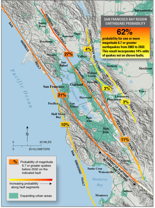
In Northern California, the Hayward Fault is of particular concern due to its proximity to densely populated urban areas. Stretching through the East Bay, it passes directly through cities like Hayward, Oakland, and Berkeley. Unlike the San Andreas, which often exhibits creeping movement, the Hayward Fault is considered to be overdue for a major rupture, posing a significant threat to the region. Its surface traces can be observed in places like the University of California, Berkeley campus and in regional parks.
The Garlock Fault
The Garlock Fault is another major strike-slip fault in Southern California, running east-west across the Mojave Desert. It extends from the San Andreas Fault near Tehachapi to the Eastern California Shear Zone. This fault has a history of significant seismic activity and its remote location means that large earthquakes could still impact surrounding areas, including the Mojave Desert and potentially the northern edge of the Los Angeles Basin.
Other Notable Faults
Beyond these prominent examples, numerous other active faults crisscross the state. The Big Pine Fault in Southern California, the Owens Valley Fault in the Eastern Sierra, and the Calaveras Fault in Northern California are just a few of the many systems that contribute to California’s seismic complexity. Each of these faults represents a potential source of future earthquakes, and their identification and monitoring are critical for seismic hazard assessment.
Fault Lines as Natural Wonders and Geological Laboratories
While fault lines are undeniably associated with the destructive power of earthquakes, they also play a profound role in shaping California’s extraordinary natural beauty. The dramatic uplift and subsidence caused by tectonic forces have sculpted mountain ranges, created valleys, and influenced the course of rivers, leading to some of the state’s most iconic landscapes.
Shaping Iconic Landscapes
The San Andreas Fault, for instance, has carved out a distinctive rift valley in many areas. The Carrizo Plain, a vast, arid grassland, offers a stunning, visible manifestation of the fault’s presence, with long, linear ridges and troughs. In contrast, the San Gabriel Mountains, bordering the Los Angeles Basin, are partly a product of uplift along compressional faults associated with the broader plate boundary. The dramatic coastline of Big Sur is also influenced by these tectonic processes, with coastal bluffs and rugged topography testament to the Earth’s ongoing geological evolution.
Opportunities for Exploration and Education
For the adventurous traveler and the scientifically curious, fault lines offer unique opportunities for exploration and education. Designated geological parks and visitor centers often highlight the evidence of fault activity, providing interpretive trails and exhibits. Visiting sites like the San Andreas Fault near Parkfield, a town known for its seismic monitoring, or exploring the fault scarps in the Mojave Desert can provide a tangible connection to the powerful forces at play beneath our feet. These experiences offer a profound appreciation for the dynamic nature of our planet and the constant geological processes that shape our world. It’s a chance to witness firsthand the monumental power that created these lands and continues to mold them, a living geology lesson etched into the very fabric of California.
Preparing for Seismic Activity
While fault lines are integral to California’s identity, understanding their presence is paramount for safety and preparedness. The state has a robust infrastructure for monitoring seismic activity, with organizations like the United States Geological Survey (USGS) and the California Geological Survey constantly studying fault behavior and seismic risks.
Staying Informed and Prepared
For residents and visitors alike, familiarizing oneself with local seismic hazards is a crucial step. This includes understanding evacuation routes, securing heavy objects in homes or hotels, and participating in earthquake drills. Many communities offer resources and workshops on earthquake preparedness, providing vital information on how to respond before, during, and after a seismic event. Embracing preparedness transforms the awareness of fault lines from a source of anxiety into a catalyst for responsible engagement with this unique geological environment.
The presence of fault lines is an intrinsic characteristic of California, a testament to its position on a highly active tectonic boundary. By understanding where these geological features lie and respecting their power, one can fully appreciate the breathtaking beauty and enduring spirit of the Golden State, while also ensuring a safe and informed experience.
LifeOutOfTheBox is a participant in the Amazon Services LLC Associates Program, an affiliate advertising program designed to provide a means for sites to earn advertising fees by advertising and linking to Amazon.com. Amazon, the Amazon logo, AmazonSupply, and the AmazonSupply logo are trademarks of Amazon.com, Inc. or its affiliates. As an Amazon Associate we earn affiliate commissions from qualifying purchases.