
Wildfires in California are a recurring and often devastating natural phenomenon, significantly impacting the state’s diverse landscapes and the experiences of visitors. Understanding the current and historical patterns of these fires is crucial for travelers planning to explore the Golden State, especially for those seeking to appreciate its natural beauty. While the image of a raging wildfire can be alarming, context and information are key to navigating these potential challenges and ensuring safe, enjoyable travel. This exploration delves into the primary regions affected by wildfires, the factors contributing to their occurrence, and how travelers can stay informed to make wise decisions about their California adventures.

Understanding California’s Fire Landscape
California’s vast and varied geography, coupled with its Mediterranean climate, creates a natural propensity for wildfires. These fires, while sometimes destructive, are also a natural part of many ecosystems, clearing out underbrush and promoting new growth. However, human activity and increasingly dry conditions can exacerbate their intensity and spread.
Key Fire-Prone Regions
Certain areas within California are historically more susceptible to wildfires due to a combination of vegetation type, topography, and weather patterns.
Southern California Mountains and Foothills
The rugged mountain ranges that surround many of Southern California’s populated areas, such as the San Gabriel Mountains and the Santa Monica Mountains, are particularly prone to fires. The dense chaparral and coastal sage scrub vegetation in these regions can become extremely dry during the hot, arid summers and can ignite rapidly, with strong Santa Ana winds often fanning the flames towards populated areas and important transportation corridors. Popular destinations within these regions, including parts of Los Angeles County and Ventura County, can experience significant impacts.
Sierra Nevada Mountain Range
Further north, the vast Sierra Nevada mountain range, home to iconic landmarks like Yosemite National Park and Sequoia National Park, is also a significant fire zone. The dense forests of pine, fir, and cedar, combined with steep terrain, provide ample fuel. While fires are a natural part of the Sierra ecosystem, larger, more destructive fires have become more common in recent years, sometimes impacting access to these beloved national parks and altering the scenic vistas that draw millions of visitors. Areas surrounding Lake Tahoe and the eastern slopes also see fire activity.
Northern California Coast and Inland Forests
The diverse landscapes of Northern California, from the coastal redwood forests to the inland pine and oak woodlands, are also subject to wildfire risk. The drier interior regions, including parts of Shasta County and the Mendocino National Forest, can experience intense fires. The North Coast’s cooler, damper climate generally offers some protection, but prolonged dry spells and high winds can lead to significant fire events, impacting areas like the wine country of Napa Valley and Sonoma County.
Factors Influencing Wildfire Occurrence
Several interconnected factors contribute to the prevalence and intensity of wildfires in California.
Climate and Weather Patterns
California’s Mediterranean climate, characterized by long, dry summers and mild, wet winters, inherently creates a fire-prone environment. Prolonged drought conditions, which have become more frequent and severe in recent decades, dry out vegetation, making it highly flammable. High temperatures and low humidity further increase the risk. Additionally, strong winds, such as the aforementioned Santa Ana winds in the south and the Diablo winds in the north, can rapidly spread fires and make them exceptionally difficult to control.
Vegetation and Fuel Load
The type and density of vegetation play a critical role. Chaparral, coastal sage scrub, and dense conifer forests are highly combustible. Years of fire suppression have, in some areas, led to an accumulation of dead vegetation and underbrush, acting as an increased fuel load that can sustain larger and more intense fires.
Human Activity
While lightning can ignite wildfires, a significant percentage are caused by human activity, ranging from accidental sparks from equipment and campfires to deliberate arson. The proximity of developed areas to wildlands increases the risk of human-ignited fires and the potential for rapid spread into communities.
Staying Informed for Your California Journey
For travelers, awareness and preparation are key to navigating California’s wildfire season and ensuring a safe and memorable trip. Understanding where fires are currently active and the potential risks in your intended destinations allows for informed decision-making.
Real-Time Information Resources
Accessing up-to-date information on wildfire activity is paramount. Several official sources provide real-time updates.
Government Agencies
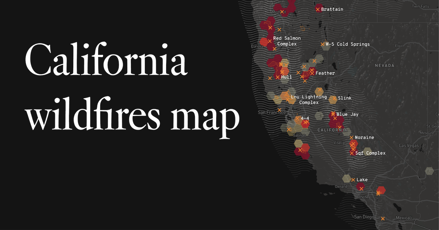
The California Department of Forestry and Fire Protection (CAL FIRE) is the primary state agency responsible for wildfire prevention and suppression. Their website and social media channels offer detailed incident maps, evacuation information, and road closures. Similarly, the U.S. Forest Service provides crucial information for fires occurring on federal lands, including national forests and parks.
Local Emergency Services and News Outlets
Local county emergency services often issue alerts and evacuation orders specific to their jurisdictions. Following local news outlets in your intended travel area can also provide timely updates on localized fire activity and its impact on attractions, accommodations, and transportation.
Planning Your Travel Safely
Integrating wildfire awareness into your travel planning can help mitigate potential disruptions and ensure your safety.
Checking Conditions Before Departure
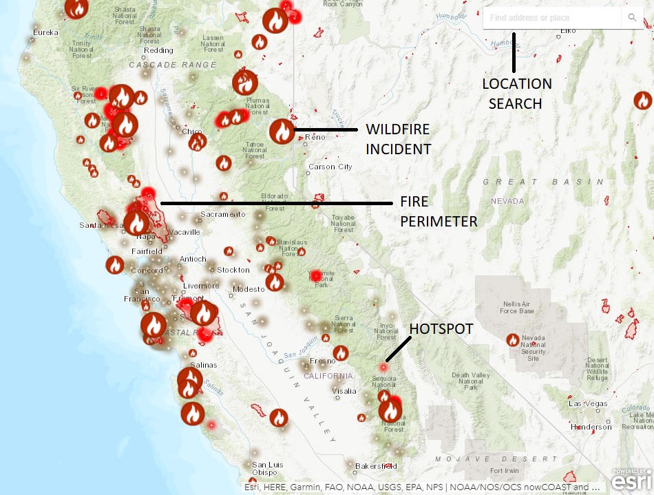
Before embarking on your trip, always check the current wildfire situation in the regions you plan to visit. Websites like CAL FIRE’s incident map are invaluable for this. Look for any red flag warnings or significant fire activity that might impact your travel plans.
Flexibility in Itinerary
If traveling during wildfire season, it is advisable to build some flexibility into your itinerary. Have backup plans in case your primary destinations become inaccessible due to fires, smoke, or evacuations. Consider alternative regions or activities that might be less affected.
Understanding Air Quality
Wildfires can significantly impact air quality, even in areas not directly affected by the flames, due to smoke. Check air quality indexes (AQI) for your destination. If air quality is poor, consider postponing outdoor activities or choosing indoor attractions. This is particularly important for individuals with respiratory conditions.
Awareness of Evacuation Routes and Shelter-in-Place Orders
Familiarize yourself with general evacuation routes in the areas you will be visiting. While direct encounters with evacuations are unlikely for most travelers, awareness can be beneficial. Always heed any official evacuation orders or shelter-in-place directives issued by authorities.
Experiencing California’s Natural Wonders Amidst Fire Risk
California’s allure lies in its breathtaking natural landscapes. While wildfire risk is a reality, many travelers can still experience its beauty responsibly.
Adapting Travel Plans
The most effective approach is to adapt your travel plans to current conditions rather than abandoning them entirely.
Focusing on Coastal and Urban Destinations
Coastal areas, with their higher humidity, and urban centers are generally less susceptible to the immediate impact of wildfires compared to inland forests and mountain ranges. Cities like San Francisco, San Diego, and Los Angeles offer a wealth of attractions that are typically unaffected by remote fire activity, though smoke can sometimes drift into these areas.
Shifting to Less Fire-Prone Seasons
If your travel dates are flexible, consider visiting California during its wetter seasons (typically late fall through spring). While not entirely fire-free, the risk is significantly lower during these months, and the landscapes are often vibrant and lush.
Choosing Well-Managed Parks and Attractions
Many national and state parks have robust fire management plans and excellent visitor information systems. For example, the California State Parks system provides updates on conditions affecting its numerous sites. Parks with extensive visitor centers, paved roads, and designated campgrounds may offer a more controlled experience.
The Role of Wildfire in the Ecosystem
It is also important for travelers to understand that wildfires, in a controlled and natural context, are an integral part of many Californian ecosystems. Certain plant species in California, like the Ponderosa Pine, have adapted to fire, with their cones even requiring heat to open and release seeds. Understanding this ecological role can foster a deeper appreciation for the resilience of nature, even when experiencing the impacts of fires. However, this ecological perspective does not diminish the importance of safety and preparedness for human visitors.
By staying informed, planning ahead, and remaining flexible, travelers can continue to explore and enjoy the unparalleled beauty and diversity of California, even in the face of its dynamic natural challenges.
LifeOutOfTheBox is a participant in the Amazon Services LLC Associates Program, an affiliate advertising program designed to provide a means for sites to earn advertising fees by advertising and linking to Amazon.com. Amazon, the Amazon logo, AmazonSupply, and the AmazonSupply logo are trademarks of Amazon.com, Inc. or its affiliates. As an Amazon Associate we earn affiliate commissions from qualifying purchases.