
The Colorado River, a monumental natural landmark of the American West and Mexico, carves an epic journey across vast landscapes, supporting diverse ecosystems and human civilizations along its course. Understanding its origin and terminus reveals not only geographical intricacies but also the profound impact of human interaction on one of the continent’s most vital waterways. From its icy headwaters high in the Rocky Mountains to its historically vibrant, yet now largely desiccated, delta, the river’s path is a testament to natural grandeur and an urgent narrative of environmental stewardship.
The Alpine Birthplace: Genesis in the Rockies
The Colorado River’s odyssey commences in the pristine, snow-capped peaks of the Rocky Mountains within Colorado. This high-altitude genesis sets the stage for a dramatic descent and an enduring legacy as a life-sustaining force across arid regions.

La Poudre Pass and the Continental Divide
The true source of the Colorado River is often identified near La Poudre Pass in Rocky Mountain National Park, at an elevation exceeding 10,000 feet (3,048 meters). Here, minuscule trickles of snowmelt and precipitation coalesce, forming the nascent river. What begins as a modest stream near Mount Cumulus and Poudre Pass Lake quickly gains momentum, fed by numerous tributaries winding down from the surrounding peaks. This area lies on the western side of the Continental Divide, ensuring its waters flow westward towards the Pacific Ocean rather than eastward to the Atlantic. The initial stretch of the river, historically known as the Grand River, was officially renamed the Colorado River in 1921 by an act of Congress, reflecting its iconic status.
Early Flow Through the Rocky Mountain Canyons
As the young Colorado River descends from its alpine cradle, it flows through lush subalpine meadows and dense evergreen forests within Rocky Mountain National Park. It carves through a series of increasingly deep and rugged canyons, including Gore Canyon and Glenwood Canyon, showcasing the powerful erosive forces that define its character. These early sections are characterized by whitewater rapids, offering exhilarating challenges for rafters and kayakers, and providing vital habitats for cold-water fish species. The landscapes here are dramatic, with towering cliffs and verdant banks contrasting sharply with the arid environments downstream. The river collects water from numerous tributaries in Colorado, including the Blue River, the Eagle River, and the Roaring Fork River, steadily increasing its volume as it begins its westward journey.
A Grand Journey Through Arid Lands: Carving the Southwest
Leaving Colorado, the Colorado River embarks on its iconic passage through the arid and semi-arid landscapes of the American Southwest. This segment of its course is defined by colossal canyons, vast plateaus, and the immense engineering feats that harness its power.
Traversing the Colorado Plateau
The river enters Utah, cutting through the Colorado Plateau, a geological marvel known for its vivid red rock formations, towering mesas, and deep canyons. Here, it continues to gather strength from tributaries like the Green River, its largest tributary, which joins it in Canyonlands National Park. This confluence marks a significant increase in the river’s volume and power. The scenery becomes increasingly dramatic, with natural landmarks such as Dead Horse Point and the various formations within Arches National Park and Zion National Park standing as silent witnesses to the river’s ancient work. The river then bends south into Arizona, where it takes on its most famous role as the sculptor of the Grand Canyon.
Iconic Gorges and Canyons: The Grand Canyon
No discussion of the Colorado River is complete without acknowledging its most magnificent creation: the Grand Canyon. Spanning 277 miles (446 km) long, up to 18 miles (29 km) wide, and over a mile (1.8 km) deep, this UNESCO World Heritage Site is a breathtaking testament to millions of years of erosion. The river, once a wild and powerful force, meticulously carved through layers of sedimentary rock, revealing billions of years of geological history. The sheer scale and vibrant stratification of the canyon walls are unparalleled, making it one of the world’s most recognizable natural landmarks. Within the Grand Canyon, the river continues its southward trajectory, passing significant sites like Havasu Falls and the ancient ruins left by indigenous peoples.
Major Dams and Reservoirs: Lake Mead and Lake Powell
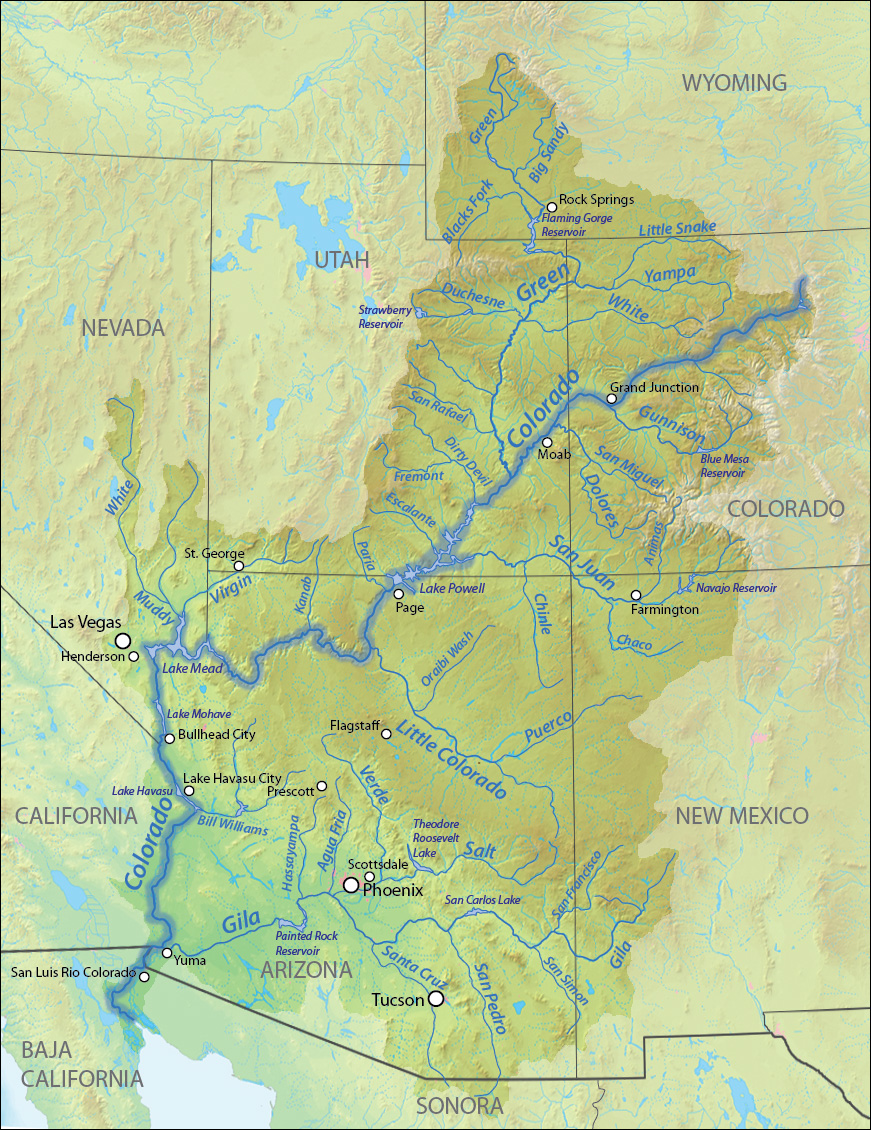
Beyond the Grand Canyon, the Colorado River’s flow is significantly altered by a series of monumental dams and reservoirs that shape its character and provide water and hydroelectric power to millions. The most prominent of these are Glen Canyon Dam, which creates Lake Powell, and Hoover Dam, which forms Lake Mead. Lake Powell, straddling the border of Arizona and Utah, is a vast recreational area known for its stunning red rock canyons and numerous coves. Lake Mead, located on the border of Nevada and Arizona, is the largest reservoir in the United States by volume. These reservoirs regulate the river’s flow, ensuring water delivery to major urban centers like Las Vegas, Phoenix, and Los Angeles, and supporting extensive agricultural enterprises in California and Arizona. Their construction fundamentally transformed the river, converting free-flowing sections into calm, deep lakes, and dramatically reducing the natural flow downstream.
The Delta’s Diminished Reach: An Arid End
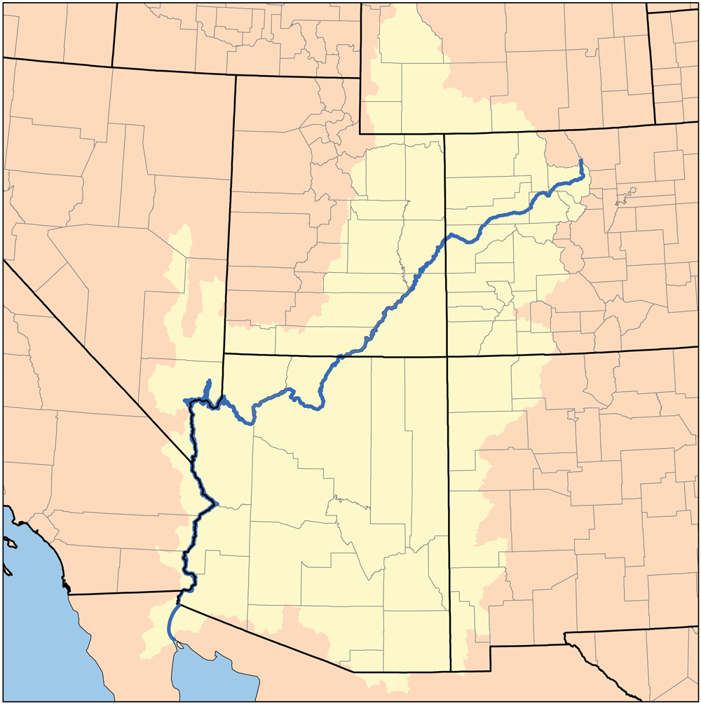
After a journey of approximately 1,450 miles (2,330 km) through seven U.S. states (Colorado, Utah, Arizona, Nevada, California, Wyoming, and New Mexico via tributaries), the Colorado River crosses into Mexico for its final, and perhaps most poignant, stretch.
Border Crossing and International Significance
The Colorado River forms a portion of the international border between Arizona and California before crossing entirely into Mexico just south of Yuma, Arizona. Here, its remaining waters are almost entirely diverted for agricultural use in the Mexicali Valley of Baja California and Sonora, Mexico. The Morelos Dam, located just downstream from the border, represents the last significant diversion point for the river’s flow, illustrating the intense competition for its precious resources. The allocation of the river’s water among U.S. states and Mexico is governed by a complex web of treaties, laws, and compacts, most notably the Colorado River Compact of 1922.
The Historical Colorado River Delta
Historically, the Colorado River emptied into the Gulf of California, forming a vast and fertile delta ecosystem. This Colorado River Delta was once a vibrant wetland, covering nearly 2 million acres (8,100 km²) of marsh, riparian forests, and tidal flats. It was a critical stopover point for millions of migratory birds and supported a rich biodiversity of fish, wildlife, and native plant species. Early explorers and indigenous communities described a lush, teeming wilderness where the river met the sea.
Modern Management and Ecological Challenges
Today, the natural end of the Colorado River is dramatically different. Due to decades of extensive damming and water diversions for agriculture and urban use across seven U.S. states and two Mexican states, the river rarely reaches the Gulf of California as a continuous surface flow. The once-thriving delta has largely dried up, replaced by salt flats and arid landscapes. Only during exceptionally wet years or through specific “pulse flows” — managed releases of water from upstream dams — does water reach the gulf, offering a temporary revitalization to portions of the delta. This diminished flow highlights the severe ecological challenges facing the river and underscores the delicate balance between human water demands and ecosystem health. Conservation efforts are now focused on restoring segments of the delta and ensuring some level of environmental flow to maintain the remaining wetland habitats.
A Lifeline in the Desert: Its Enduring Legacy as a Landmark
The Colorado River’s path, from its pristine Rocky Mountain source to its parched delta in Mexico, is more than just a geographical outline; it is a narrative of natural power, human ingenuity, and environmental consequence. As a landmark, its significance extends far beyond its physical presence.
Cultural and Historical Significance
For thousands of years, indigenous tribes, including the Pueblo, Hopi, Navajo, and Hualapai, have relied on the Colorado River for sustenance, shaping their cultures, traditions, and settlements along its banks and in its canyons. Spanish explorers, beginning with Francisco Vásquez de Coronado in the 16th century, were among the first Europeans to encounter the river, naming it “Rio Colorado”—red river—for its sediment-laden waters. Later, American pioneers, trappers, and explorers like John Wesley Powell systematically mapped its course, paving the way for the massive development projects of the 20th century. The river’s story is interwoven with the history of the American West, symbolizing both opportunity and conflict over finite resources.
Ecological Importance and Conservation Efforts
Despite the immense pressures it faces, the Colorado River remains a critical ecological corridor. Its remaining free-flowing sections and protected areas, such as the Grand Canyon National Park, provide vital habitats for endangered fish species, birds, and other wildlife. The river supports unique riparian ecosystems that are distinct from the surrounding desert. Conservation groups, government agencies, and international collaborations are actively working to address the challenges of water scarcity, climate change, and habitat degradation. Efforts include promoting water conservation, exploring innovative management strategies, and pursuing targeted restoration projects in the delta and other degraded areas. The ongoing struggle to balance human needs with the ecological integrity of the Colorado River underscores its enduring status as a natural landmark whose fate holds profound implications for both nature and society.
LifeOutOfTheBox is a participant in the Amazon Services LLC Associates Program, an affiliate advertising program designed to provide a means for sites to earn advertising fees by advertising and linking to Amazon.com. Amazon, the Amazon logo, AmazonSupply, and the AmazonSupply logo are trademarks of Amazon.com, Inc. or its affiliates. As an Amazon Associate we earn affiliate commissions from qualifying purchases.