
Arizona, a state painted with the vibrant hues of the desert Southwest, occupies a distinct and geographically significant position within the United States. Its placement is not merely a matter of longitude and latitude, but a confluence of natural landscapes, historical narratives, and cultural influences that define its unique identity. Understanding where Arizona lies is the first step to appreciating its allure for travelers, adventurers, and those seeking an immersive experience in the American West.
The Geographical Core: Southwest Positioning and Key Borders
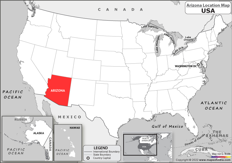
Arizona is firmly rooted in the Southwest region of the United States, a designation that evokes images of arid beauty, majestic canyons, and a rich tapestry of Native American and Hispanic heritage. Its strategic location places it at the crossroads of several significant geological and ecological zones, contributing to its diverse terrain.
Bordering States and Their Influence
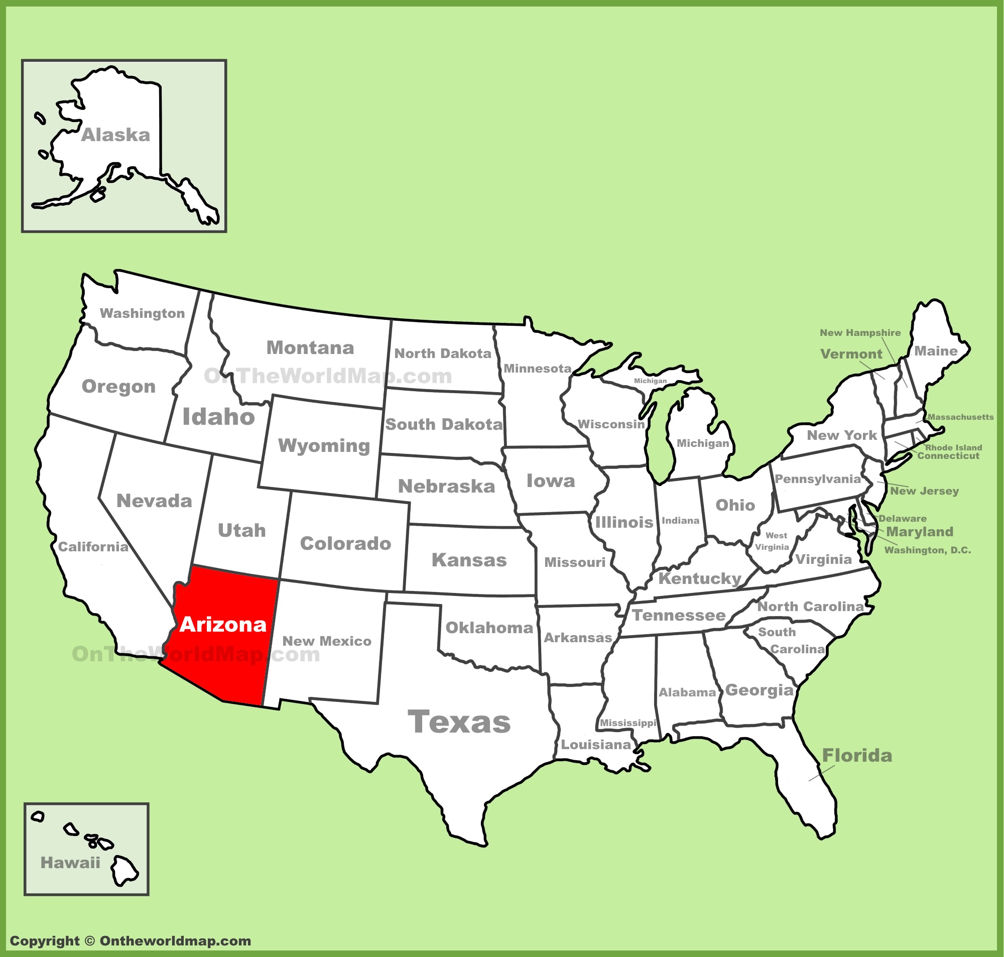
To pinpoint Arizona’s location more precisely, consider its neighboring states, each contributing to the region’s character:
- California: To the west, Arizona shares a border with the Golden State. This proximity influences trade, cultural exchange, and the flow of tourism, particularly in areas like Yuma and the western desert regions. The Colorado River, a vital water source, forms a significant portion of this boundary.
- Nevada: To the northwest, Arizona’s border with Nevada is marked by the mighty Colorado River and the iconic Hoover Dam. This connection opens avenues for visitors to explore attractions like Lake Mead and the glitz of Las Vegas.
- Utah: The northeastern border of Arizona is shared with Utah. This region is renowned for its spectacular red rock landscapes and is part of the larger geological marvel known as the Colorado Plateau. The proximity to Zion National Park and Bryce Canyon National Park in Utah makes the northern reaches of Arizona a gateway to these natural wonders.
- New Mexico: To the east, Arizona shares a lengthy border with New Mexico. This shared boundary further solidifies the Southwest identity, with influences in art, cuisine, and historical sites evident in both states. Areas like the Gila Wilderness in New Mexico are geographically close to Arizona’s southern ranges.
- Mexico: To the south, Arizona has a significant international border with Mexico, specifically with the Mexican states of Sonora and Chihuahua. This border is a critical artery for commerce and cultural exchange, influencing the vibrant Hispanic culture found throughout Arizona, particularly in cities like Tucson and along the border towns.
- Colorado: While sharing a very small quadripoint (a single point where four states meet) with Colorado in the northeast, the direct geographical influence is less pronounced than with its other bordering states.
The Cardinal Directions of Arizona
Arizona’s interior is defined by its cardinal directions, each offering a distinct travel experience:
- Northern Arizona: This is the land of the Grand Canyon National Park, a natural wonder of the world. Beyond the canyon, the region boasts the Petrified Forest National Park, the San Francisco Peaks (home to Arizona’s highest point), and the red rock beauty of Sedona. The climate here is cooler, with higher elevations and even snowfall in the winter months.
- Southern Arizona: Characterized by lower elevations and warmer temperatures, southern Arizona is quintessential desert country. It is home to the Sonoran Desert, with its iconic saguaro cacti, and vibrant cities like Tucson and Phoenix. This region is rich in Native American history, Spanish colonial influence, and offers a gateway to Mexico.
- Eastern Arizona: This part of the state offers a more mountainous and forested landscape, reminiscent of the Rocky Mountains in some areas. Attractions include the White Mountains, ancient Native American ruins like those at Casa Grande Ruins National Monument, and charming historic towns.
- Western Arizona: Dominated by desert expanses, the western part of Arizona is also shaped by the Colorado River. This area is crucial for agriculture, with vast irrigated farmlands around Yuma, and offers unique desert scenery and access to historic Route 66 towns.
Navigating Arizona: Key Cities and Transportation Hubs
Arizona’s position on the map is further clarified by its major urban centers and transportation networks, which serve as focal points for travelers.
The Metropolitan Heart: Phoenix and Tucson
- Phoenix: As the state capital and its largest city, Phoenix is the undeniable metropolitan heart of Arizona. Located in the central-southern part of the state, it sits in the Salt River Valley. Phoenix Sky Harbor International Airport is a major hub for air travel, connecting visitors from across the globe to Arizona’s wonders. The city’s sprawling urban landscape serves as a launching point for exploring both northern and southern Arizona.
- Tucson: Situated about 115 miles south of Phoenix, Tucson is Arizona’s second-largest city. Nestled in the Sonoran Desert, it boasts a rich cultural heritage, influenced by its proximity to Mexico. Tucson International Airport provides convenient air access, and the city serves as a gateway to southern Arizona’s natural beauty and historical sites.
Major Transportation Arteries
Arizona’s connectivity is facilitated by a network of major highways and railways:
- Interstate 10 (I-10): This vital east-west interstate highway traverses the southern half of Arizona, connecting California at the west to New Mexico at the east. It passes directly through Phoenix and Tucson, making it a primary route for travelers entering and exiting the state.
- Interstate 17 (I-17): Running north-south, I-17 connects Phoenix to northern Arizona, including the scenic city of Flagstaff, a gateway to the Grand Canyon. This highway is crucial for accessing the cooler climates and natural attractions of the northern plateau.
- Interstate 40 (I-40): This major east-west interstate forms a significant portion of historic Route 66 and cuts across the northern tier of Arizona, connecting California to Oklahoma. It passes through cities like Kingman, Flagstaff, and Holbrook, offering access to a wealth of Route 66 attractions and natural landscapes.
- Railways: Amtrak operates passenger rail services through Arizona, with major stops in cities like Tucson, Phoenix, and Flagstaff, offering an alternative and scenic way to traverse the state.

Arizona’s Place in the Broader Context: Climate and Natural Features
Arizona’s location dictates its diverse climate and iconic natural features, which are central to its appeal as a travel destination.
The Spectrum of Aridity: Desert to Mountain Climates
Arizona is most famous for its arid and semi-arid climate, but its varied topography creates distinct climatic zones:
- Desert Climate: The majority of Arizona, particularly in the south and west, experiences a desert climate characterized by extreme heat in the summer and mild winters. This is the land of the saguaro cactus, vast plains, and dramatic rock formations.
- Mountain Climate: The higher elevations in northern and eastern Arizona, such as around Flagstaff and the White Mountains, enjoy a cooler, more temperate climate. These areas receive significant snowfall during the winter months, offering opportunities for winter sports.
- Transition Zones: The central part of the state, including areas around Phoenix and Sedona, often represents a transition between the extreme heat of the desert and the cooler mountain regions, with warm to hot summers and mild winters.
Iconic Natural Wonders Shaped by Location
Arizona’s position on the map places it within a region of immense geological significance, giving rise to some of the world’s most awe-inspiring natural landmarks:
- The Grand Canyon: Located in northern Arizona, this colossal gorge carved by the Colorado River is an undeniable testament to the erosive power of water and time. Its sheer scale and intricate layers of rock tell a story spanning millions of years.
- The Sonoran Desert: Covering much of southern and western Arizona, the Sonoran Desert is one of the most diverse deserts in the world. It is characterized by its unique flora and fauna, including the iconic saguaro cactus, palo verde trees, and a remarkable array of wildlife.
- The Painted Desert: Stretching across northeastern Arizona, this badlands region is renowned for its vividly colored strata of ancient rock formations, particularly visible in Petrified Forest National Park.
- The Colorado Plateau: This vast physiographic region encompasses northern Arizona, northwestern New Mexico, eastern Utah, and southwestern Colorado. It is characterized by its high elevation, arid climate, and dramatic erosional features, including canyons, mesas, and buttes.
- Meteor Crater: Located near Winslow, this impact crater is one of the best-preserved meteorite impact sites on Earth, providing a unique glimpse into cosmic events.
Arizona’s Cultural Crossroads: Heritage and Influence
Arizona’s geographic placement has fostered a rich cultural mosaic, blending Native American traditions, Spanish colonial history, and modern American influences.
Indigenous Roots and Enduring Traditions
Arizona is the ancestral homeland of numerous Native American tribes, including the Navajo, Hopi, Apache, and Pima, among others. Their presence is deeply woven into the state’s identity, with reservations like the Navajo Nation and the Hopi Reservation occupying significant portions of northern Arizona. Travelers can encounter ancient cliff dwellings at Mesa Verde National Park (though primarily in Colorado, the influence extends into Arizona), learn about traditional crafts, and witness vibrant ceremonies that continue to this day.
The Spanish Colonial Legacy
The Spanish exploration and settlement of the Southwest left an indelible mark on Arizona. Missions, presidios, and Spanish architectural styles can be found in many cities, particularly in the south. This influence is also evident in the state’s cuisine, language, and place names, adding a distinct flavor to the Arizona experience. Cities like Tucson and Nogales offer deep dives into this rich historical period.
A Modern Melting Pot
Today, Arizona is a dynamic blend of cultures. Its growing population includes people from all over the United States and the world, drawn by its economic opportunities, natural beauty, and lifestyle. This modern influence contributes to a vibrant arts scene, diverse culinary offerings, and a forward-looking spirit, all while respecting the deep historical and cultural foundations of the state.
In essence, understanding “Where Is Arizona On The Map?” is to understand its physical location, its connections to neighboring states and countries, its diverse internal geography, its vital transportation networks, and the rich cultural tapestry that has been shaped by its unique place in the American Southwest. It is a state that invites exploration, promising adventure, natural wonder, and cultural discovery at every turn.
LifeOutOfTheBox is a participant in the Amazon Services LLC Associates Program, an affiliate advertising program designed to provide a means for sites to earn advertising fees by advertising and linking to Amazon.com. Amazon, the Amazon logo, AmazonSupply, and the AmazonSupply logo are trademarks of Amazon.com, Inc. or its affiliates. As an Amazon Associate we earn affiliate commissions from qualifying purchases.