
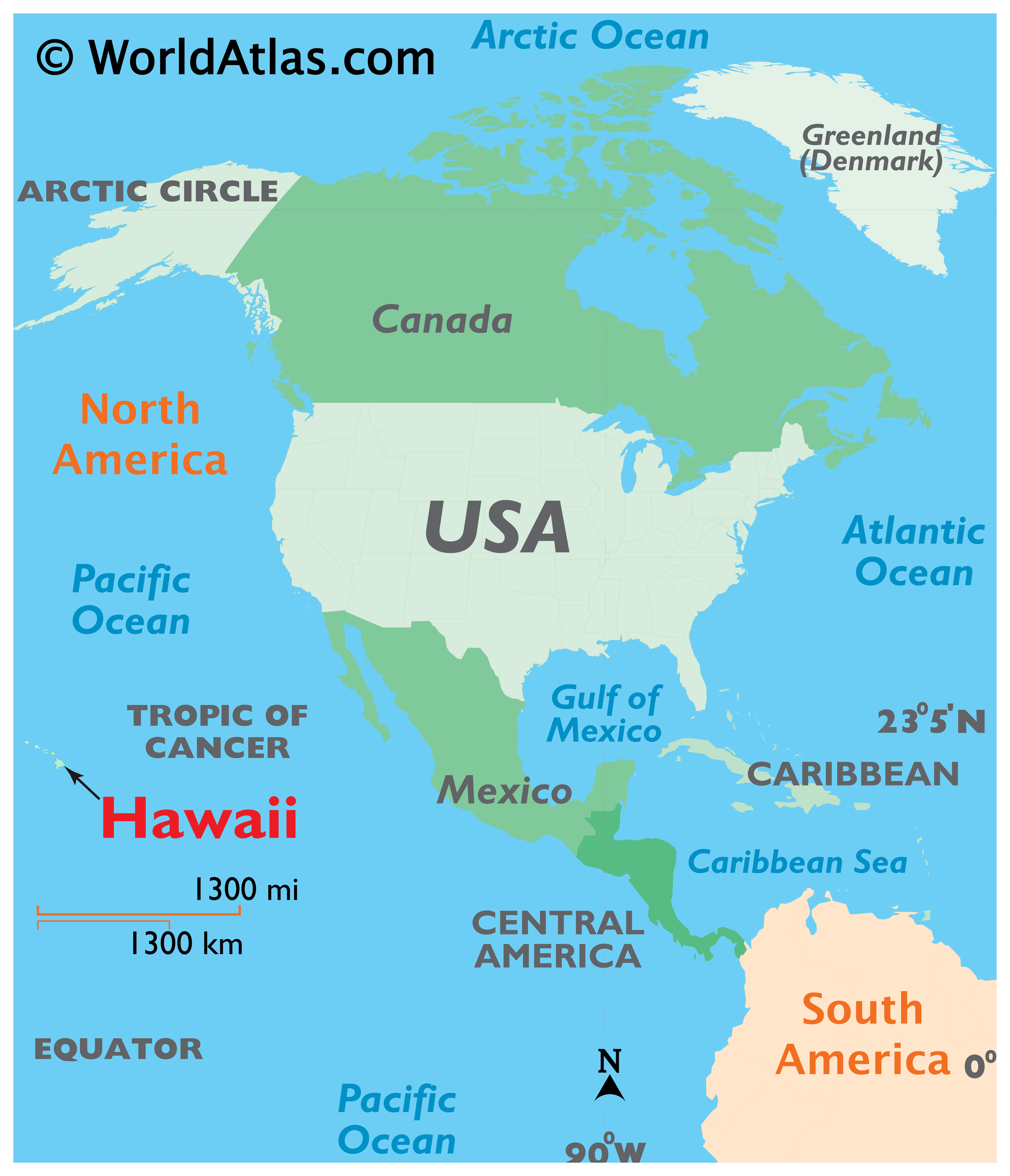
When planning a dream vacation, the first question many travelers ask is: where exactly is Hawaii located on the map? While it is famously known as the 50th state of the United States, its geographic position is quite unique. Unlike any other state in the union, this tropical paradise is situated in the middle of the Pacific Ocean, thousands of miles away from any continental landmass. Understanding its location is the first step in appreciating why it remains one of the most sought-after travel destinations in the world.
The Geographical Heart of the Pacific Ocean
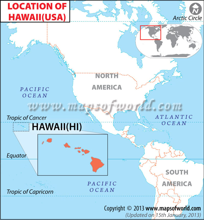
Hawaii is not just a single point on the map; it is a sprawling archipelago located in the Central Pacific. Its coordinates are approximately 21 degrees North latitude and 157 degrees West longitude. This places the islands in the northern hemisphere, just south of the Tropic of Cancer. Because of this specific placement, the islands enjoy a tropical climate year-round, making it a premier choice for sun-seekers from around the globe.
The Isolated Splendor of the Central Pacific
One of the most fascinating aspects of Hawaii is its isolation. It is often cited as the most isolated population center on Earth. To the east, the nearest major landmass is North America. The distance from California to the shores of Honolulu is roughly 2,400 miles. To the west, the nearest major continent is Asia, with Japan sitting approximately 3,800 miles away.
This isolation has significant implications for travel. It means that every visitor arriving in the islands must do so via a long-haul flight or a multi-day cruise. However, it is this very remoteness that has allowed the islands to develop a unique ecosystem and a culture that feels worlds apart from the hustle and bustle of the mainland. When you look at a global map, Hawaii appears as a tiny speck in a vast blue expanse, yet it holds a monumental presence in the world of international travel.
Distances from Global Hubs
To give travelers a better sense of where Hawaii is located on the map relative to their home, consider these flight distances. A flight from Los Angeles or San Francisco typically takes about five to six hours. If you are traveling from the East Coast, such as New York City, you are looking at a journey of nearly eleven hours.
International travelers from Sydney, Australia, or Tokyo, Japan, also find themselves traveling significant distances, often between eight and ten hours. This central location makes Hawaii a convenient middle ground for travelers from the Pacific Rim, serving as a bridge between the East and the West.
Identifying the Islands on the Map
When you zoom in on a map of Hawaii, you will see that the state is composed of 137 islands, islets, and atolls. However, for most travelers, the focus is on the eight main islands that comprise the southeastern end of the chain. These islands are the primary destinations for tourism, each offering a distinct personality and landscape.
Oahu: The Gathering Place
Oahu is the most populous island and home to the state capital, Honolulu. On a map, it is located between Kauai and Molokai. Most international flights land at Daniel K. Inouye International Airport, making it the primary gateway for visitors. Oahu is famous for its iconic landmarks, such as Waikiki Beach, Diamond Head, and the historic Pearl Harbor. It is the perfect blend of urban sophistication and natural tropical beauty.
Maui: The Valley Isle
To the southeast of Oahu lies Maui, the second-largest island in the chain. Known for its world-class resorts and the breathtaking Hana Highway, Maui is a favorite for honeymooners and luxury travelers. On the map, you can identify Maui by its distinctive “head and shoulders” shape, created by two large volcanic peaks: Haleakala and the West Maui Mountains.
The Big Island: Hawaii
The largest island in the archipelago is formally named Hawaii, but it is almost universally referred to as the Big Island to avoid confusion with the state name. Located at the southernmost tip of the chain, it is nearly twice as large as all the other islands combined. It is home to Hawaii Volcanoes National Park, where the earth is literally expanding due to volcanic activity from Kilauea. For travelers, the Big Island offers an incredible diversity of climates, from the lava deserts of Kona to the lush rainforests of Hilo.

Kauai: The Garden Isle
The northernmost of the main islands is Kauai. Geologically the oldest, it has been sculpted by millions of years of erosion, resulting in dramatic cliffs and deep canyons. The Na Pali Coast and Waimea Canyon are its most famous natural landmarks. On a map, Kauai sits somewhat apart from the more central cluster of islands, reinforcing its reputation as a rugged, untouched paradise for outdoor enthusiasts.
The Geological Significance of the Hawaiian Ridge
To truly understand where Hawaii is located on the map, one must look beneath the surface of the ocean. The islands we see are actually the tips of massive undersea mountains, part of the Hawaiian-Emperor Seamount Chain. This chain stretches over 3,600 miles across the floor of the Pacific Ocean.
A Chain Born of Fire
The location of Hawaii is the result of a “hotspot” in the Earth’s mantle. As the Pacific Plate moves slowly to the northwest, this stationary hotspot sends magma upward, creating new islands. This is why the islands to the northwest, like Kauai, are older and more eroded, while the islands to the southeast, like the Big Island, are younger and still volcanically active.
Looking at a topographic map of the ocean floor reveals that Hawaii is just the most recent chapter in a geological story that began millions of years ago. There is even a new island, named Loihi Seamount, currently forming beneath the waves off the coast of the Big Island, though it won’t break the surface for another 10,000 to 100,000 years.
The Northwestern Hawaiian Islands
Beyond the main eight islands, the archipelago continues for hundreds of miles to the northwest. These are the Northwestern Hawaiian Islands, most of which are uninhabited atolls and coral reefs. This area is part of the Papahanaumokuakea Marine National Monument, one of the largest marine conservation areas in the world. While these islands are not typical travel destinations, their location on the map is vital for the protection of Pacific biodiversity.
Practical Navigation for Modern Travelers
Knowing where Hawaii is located on the map is essential for logistical planning. Because the islands are so spread out, travelers often choose to “island hop” during their stay. This requires a basic understanding of the spatial relationship between the islands to maximize time and minimize travel fatigue.
Flight Paths and Major Gateways
Inter-island travel is almost exclusively done by air. Hawaiian Airlines and Southwest Airlines are the primary carriers connecting the islands. Most flights are very short—often between 20 and 50 minutes. For example, a flight from Honolulu to Kahului Airport on Maui is just a quick hop across the Pailolo Channel.
When mapping out your trip, it is helpful to note that Honolulu serves as the central hub. While there are some direct flights from the United States Mainland to Maui, Kauai, and the Big Island, many travelers will find themselves passing through Oahu at least once.
Time Zones and the International Date Line
Hawaii follows Hawaii-Aleutian Standard Time (HST). One of the most important things for travelers to remember is that Hawaii does not observe Daylight Saving Time. This means the time difference between Hawaii and cities like Los Angeles or New York City changes twice a year.
Furthermore, because Hawaii is located east of the International Date Line, travelers arriving from Asia or Australia will “gain” a day when traveling toward the islands. Conversely, when heading back west, they will “lose” a day. This quirk of global positioning is a key consideration for anyone coordinating international travel schedules.
In conclusion, Hawaii is much more than just a pin on a map; it is a sprawling, volcanic wonder located in the vast heart of the Pacific Ocean. Its unique location provides the perfect conditions for a tropical escape that is unlike anything else on earth. Whether you are navigating the streets of Honolulu or exploring the volcanic craters of the Big Island, knowing your place in the Pacific enhances the experience of visiting this extraordinary destination.
LifeOutOfTheBox is a participant in the Amazon Services LLC Associates Program, an affiliate advertising program designed to provide a means for sites to earn advertising fees by advertising and linking to Amazon.com. Amazon, the Amazon logo, AmazonSupply, and the AmazonSupply logo are trademarks of Amazon.com, Inc. or its affiliates. As an Amazon Associate we earn affiliate commissions from qualifying purchases.