
Houston, a sprawling metropolis often perceived as a singular entity, is in fact a complex tapestry woven into the fabric of the Texas landscape. Understanding its geographical placement is more than just an exercise in cartography; it’s an essential first step for any traveler, business visitor, or curious explorer looking to navigate and appreciate the nuances of this dynamic region. Situated in the southeastern quadrant of Texas, Houston anchors a significant portion of the state’s economic and cultural activity, serving as a vital gateway and a destination in its own right.
Southeastern Texas: A Strategic Hub
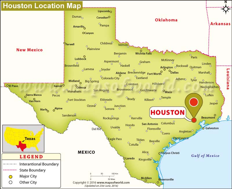
The geographical positioning of Houston is fundamental to its identity and influence. Located just about 50 miles west of the Gulf of Mexico, its proximity to this major body of water has historically shaped its development, particularly in trade and industry. This coastal proximity also influences its climate, contributing to the warm, humid conditions characteristic of the region.
Coastal Proximity and Its Impact
Being so close to the Gulf of Mexico imbues Houston with a unique character. It fosters a connection to maritime activities, including the bustling Port of Houston, one of the busiest in the United States. This port serves as a critical conduit for international trade, facilitating the import and export of goods that are vital to the Texan and national economy. For travelers, this means easier access to cruise lines and a constant influx of diverse cultural influences. The coastal air, even inland, subtly affects the atmosphere, bringing with it the scent of the sea and a palpable sense of the vastness of the American coastline.
Elevation and Drainage
Houston sits at a very low elevation, generally around 50 feet above sea level. This low-lying terrain, combined with the region’s abundant rainfall, necessitates an extensive and sophisticated system of bayous, canals, and drainage infrastructure. These waterways are not merely functional; they are integral to the city’s aesthetic and recreational offerings, with many residents enjoying activities like kayaking and fishing along their banks. However, this low elevation also means the city is particularly vulnerable to flooding, a factor that has shaped its urban planning and disaster preparedness strategies. Understanding this characteristic is crucial for planning any outdoor activities or navigating the city during its wetter seasons.
Surrounding Terrain
The terrain around Houston is predominantly flat coastal prairie. This vast, open landscape is characteristic of much of southeastern Texas. Historically, this type of terrain was ideal for cattle ranching and agriculture, and while these industries still have a presence in the broader region, Houston has long since transitioned into a major urban and industrial center. The flatness contributes to unobstructed views in many areas, particularly as one drives away from the dense urban core, revealing expansive skies and the characteristic Texan horizons.
Houston’s Place Among Major Texas Cities
To truly pinpoint Houston on the Texas map, it’s helpful to situate it relative to other prominent cities in the state. Texas is the second-largest state in the U.S. by both area and population, and its major cities form a powerful economic and cultural network.
Proximity to Other Metropolises

Houston is located east of San Antonio and Austin, and northeast of Corpus Christi. It is also west of New Orleans in neighboring Louisiana. This eastward positioning is a key differentiator. While Austin is known for its live music and state capitol charm, and San Antonio for its historic Alamo and Riverwalk, Houston carves its own identity as a global hub for energy, aerospace, and medicine. The drive between these cities offers a geographic narrative of Texas, with changing landscapes and subtle cultural shifts.
The Texas Triangle
Houston is a corner of the vast “Texas Triangle,” a conceptual region formed by its four largest metropolitan areas: Houston, Dallas-Fort Worth, San Antonio, and Austin. This interconnected network accounts for a significant portion of the state’s population and economic output. Houston represents the southeastern anchor of this triangle, with the vast expanse of East Texas stretching to its north and east. Understanding this regional grouping helps contextualize Houston’s role not just as a city, but as a vital node in a larger, interconnected economic and social system.
Navigational Landmarks and Transportation Corridors
Beyond its relation to other cities and the state’s geography, understanding Houston’s location can also be aided by key navigational landmarks and the major transportation routes that converge there.
Major Highways and Interstates
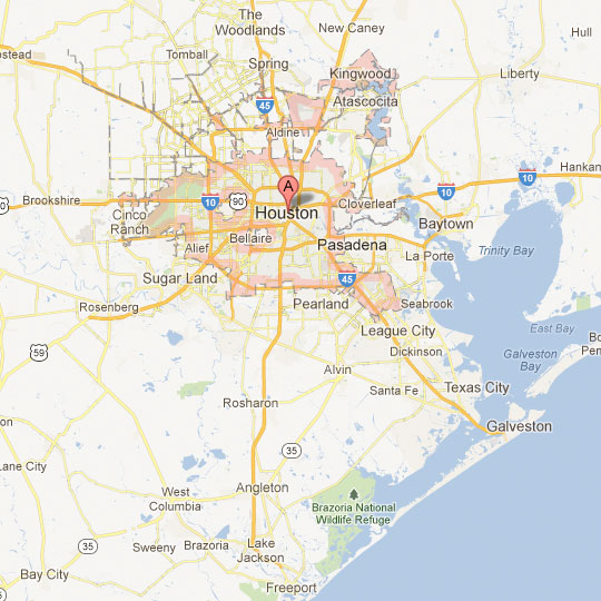
The city is crisscrossed by a network of major highways, serving as vital arteries for both intra-city travel and long-distance transit. I-45 runs north-south, connecting Houston to Dallas and points beyond. I-10 is an east-west superhighway that links Houston to San Antonio and El Paso in Texas, and extends all the way to California on the West Coast. US 59 (now I-69) is another critical north-south corridor, leading into Mexico. The city’s sprawling nature means that understanding these major roadways is paramount for efficient navigation. The sheer scale of these arteries underscores Houston’s significance as a transportation hub.
Airports as Gateways
Houston is served by two major airports: George Bush Intercontinental Airport (IAH) and William P. Hobby Airport (HOU). IAH is the larger of the two, serving as a major international gateway and a hub for United Airlines. It is located north of the city center. Hobby Airport, situated south of downtown, is primarily a domestic airport and a focus city for Southwest Airlines. The locations of these airports are key markers on any map of the region, signifying Houston’s connectivity to the rest of the world.
Iconic Bayous and Waterways
While not always immediately apparent on a standard road map, the intricate network of bayous and rivers is a defining geographical feature of Houston. The Buffalo Bayou is perhaps the most famous, flowing through the heart of the city and serving as a historical landmark and a recreational asset. Other significant waterways include White Oak Bayou, Sims Bayou, and the Houston Ship Channel, which connects the Port of Houston to the Gulf of Mexico. These waterways are crucial for understanding the city’s layout and its historical development, particularly in its early days as a port town.
A Global City in the Heart of Texas
In conclusion, Houston’s placement on the Texas map is defined by its southeastern location, its proximity to the Gulf of Mexico, its role within the Texas Triangle, and the vital transportation corridors that converge upon it. It is a city that leverages its geography to become a global center for industry, innovation, and culture, all while retaining a distinct Texan spirit. For anyone planning a visit or seeking to understand this dynamic urban landscape, recognizing its geographical roots is the first step to unlocking the full experience of what Houston has to offer. Its location is not just a point on a map; it’s the foundation upon which its identity and influence are built.
LifeOutOfTheBox is a participant in the Amazon Services LLC Associates Program, an affiliate advertising program designed to provide a means for sites to earn advertising fees by advertising and linking to Amazon.com. Amazon, the Amazon logo, AmazonSupply, and the AmazonSupply logo are trademarks of Amazon.com, Inc. or its affiliates. As an Amazon Associate we earn affiliate commissions from qualifying purchases.