
Understanding the map of Los Angeles is often the first challenge for any traveler planning a visit to the second-largest city in the United States. Unlike many European capitals or even New York City, which possess a clear, centralized urban core, Los Angeles is a sprawling metropolis of interconnected neighborhoods, diverse topographies, and unique micro-climates. To find where Los Angeles is on a map is to look at the sun-drenched coast of Southern California, nestled between the Pacific Ocean and several rugged mountain ranges. This guide provides a deep dive into the geography, districts, and essential landmarks that define the Los Angeles landscape, helping you navigate this complex and captivating destination with ease.
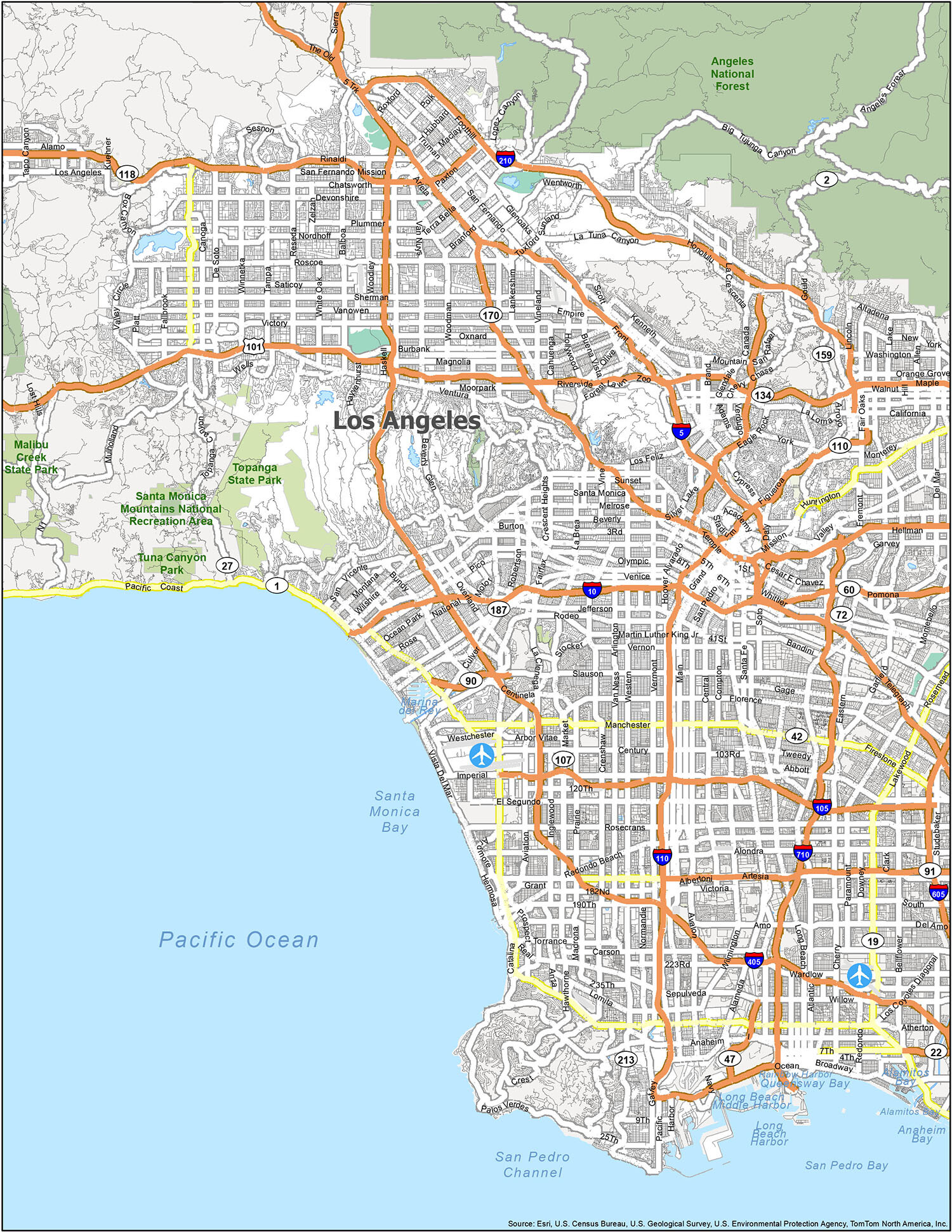
Understanding the Geography and Location of Los Angeles
To truly grasp the map of Los Angeles, one must first look at its broader context within California. The city serves as the cultural and financial hub of the West Coast, sitting approximately 340 miles south of San Francisco and 120 miles north of San Diego. It is a city defined by its dramatic contrasts—where the deep blue of the ocean meets the arid golden hues of the desert foothills.
The Pacific Gateway in Southern California
Los Angeles is positioned on a hilly coastal plain. Its western boundary is defined by the Santa Monica Bay, a crescent-shaped stretch of coastline that hosts some of the world’s most famous beaches. The orientation of the city is primarily north-south along the coast, but it extends significantly inland toward the east. This proximity to the Pacific Ocean is not just a scenic asset; it dictates the city’s weather patterns and lifestyle. The “marine layer” often blankets the coastal areas in the morning, while the inland valleys, such as the San Fernando Valley, experience much higher temperatures.
The Vast Reach of Los Angeles County
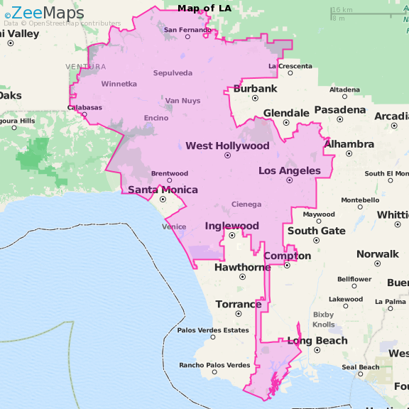
When people search for a Los Angeles map, they are often looking at Los Angeles County, an enormous administrative area that encompasses 88 incorporated cities. The city of Los Angeles itself is the anchor, but it is surrounded by other famous municipalities like Santa Monica, Beverly Hills, and West Hollywood. To the north and east, the city is hemmed in by the San Gabriel Mountains and the Santa Susana Mountains. These natural borders create a basin that contains the urban sprawl, though the city has famously climbed the hillsides to create neighborhoods with stunning panoramic views.
Navigating the Districts: A Map of Iconic Neighborhoods
The best way to visualize a Los Angeles map is to break it down into its primary districts. Each area functions almost like its own city, with a distinct personality, architectural style, and set of attractions. Navigating between these hubs requires an understanding of the local geography and the freeway systems that connect them.
The Heart of the City: Downtown Los Angeles
Commonly referred to as DTLA, Downtown Los Angeles is the historic and geographic center of the region. On a map, it is located inland, east of the coastal neighborhoods. Over the last two decades, DTLA has undergone a massive revitalization. It is home to the Arts District, where former warehouses have been converted into trendy galleries and lofts, and the Financial District, characterized by towering skyscrapers. Key cultural landmarks like the Walt Disney Concert Hall and The Broad museum are situated here, making it a vital stop for art and music enthusiasts.
Glitz and Glamour: Hollywood and Beverly Hills
Just northwest of Downtown Los Angeles lies Hollywood. This area is perhaps the most famous part of the city, synonymous with the global film industry. On a map, Hollywood sits at the base of the Santa Monica Mountains. Adjacent to Hollywood is West Hollywood, known for its vibrant nightlife and the Sunset Strip. Continuing west, you enter Beverly Hills, an independent city completely surrounded by Los Angeles. This area is the pinnacle of luxury, featuring the world-renowned Rodeo Drive shopping district and iconic hotels like The Beverly Hills Hotel.
Sun and Surf: Santa Monica and Venice Beach
The western edge of the Los Angeles map is dominated by the coast. Santa Monica is a premier destination for travelers, offering a blend of urban sophistication and beachside relaxation. The Santa Monica Pier is a major landmark, visible from miles away. Just south of Santa Monica is Venice Beach, famous for its bohemian Ocean Front Walk and the Venice Canals. This coastal strip is the best place to experience the quintessential California lifestyle, with plenty of opportunities for surfing, biking, and people-watching.
Key Landmarks and Topography on the Los Angeles Map
Beyond the neighborhoods, certain geographical and man-made landmarks serve as essential waypoints on any Los Angeles map. These sites provide context to the city’s history and its relationship with the natural world.
The Majestic Santa Monica Mountains
One of the most defining features of the Los Angeles landscape is the Santa Monica Mountains range. These mountains run through the heart of the city, separating the Los Angeles Basin from the San Fernando Valley. Perched high in these hills is the Griffith Observatory, which offers the most famous view of the Hollywood Sign. The mountains are also home to Griffith Park, one of the largest municipal parks with urban wildlands in the United States. For those looking for a nature escape within the city, the trails in Runyon Canyon Park or Topanga State Park offer a rugged contrast to the urban streets below.
Cultural Anchors and Artistic Hubs
When exploring the map, travelers should look for major cultural anchors that define the city’s intellectual life. The Getty Center, located in the Brentwood neighborhood, is an architectural marvel sitting atop a hill overlooking the 405 Freeway. Its sister site, the Getty Villa, is located further west in Pacific Palisades, modeled after an ancient Roman country house. In the Miracle Mile district, you will find the Los Angeles County Museum of Art (LACMA) and the fascinating La Brea Tar Pits, where prehistoric fossils are still being excavated today.
Logistics and Transportation: Mapping Your Journey
Navigating Los Angeles requires more than just knowing where places are; it requires understanding how to get between them. The city’s infrastructure is legendary, characterized by a massive network of freeways and a growing public transit system.
Arriving via Los Angeles International Airport
Most international and domestic travelers enter the city through Los Angeles International Airport, commonly known as LAX. On a map, LAX is located on the coast, south of Santa Monica and Venice Beach. It serves as the primary gateway to Southern California. From here, travelers can head north to the coastal cities, east toward Downtown Los Angeles, or south toward the South Bay communities like Manhattan Beach and Hermosa Beach.

The Freeway Culture and Public Transit
The Los Angeles map is crisscrossed by several major freeways. The 101 Freeway (Hollywood Freeway) connects the valley to Downtown Los Angeles. The I-10 (Santa Monica Freeway) is the main east-west artery, running from the beach all the way to the Inland Empire. For those preferring not to drive, the Los Angeles Metro offers rail lines that connect major hubs. The Expo Line, for instance, provides a direct link between Downtown Los Angeles and Santa Monica, bypassing the often-heavy traffic. Union Station in Downtown Los Angeles serves as the grand central hub for Amtrak, Metrolink, and regional buses.
In conclusion, the Los Angeles map is a tapestry of varied experiences. Whether you are looking for the cinematic history of Hollywood, the luxury of Beverly Hills, the cultural depth of Downtown Los Angeles, or the natural beauty of the Pacific Ocean, understanding the layout of this vast city is the key to a successful journey. By breaking the city down into its geographic components and identifying the major landmarks, you can navigate the “City of Angels” with the confidence of a local, ensuring you don’t miss any of the wonders Southern California has to offer. From the heights of Mount Wilson to the shores of Malibu, the map of Los Angeles is a guide to one of the most dynamic regions on earth.
LifeOutOfTheBox is a participant in the Amazon Services LLC Associates Program, an affiliate advertising program designed to provide a means for sites to earn advertising fees by advertising and linking to Amazon.com. Amazon, the Amazon logo, AmazonSupply, and the AmazonSupply logo are trademarks of Amazon.com, Inc. or its affiliates. As an Amazon Associate we earn affiliate commissions from qualifying purchases.