New York, a name that resonates globally, conjures images of soaring skyscrapers, bustling avenues, and a vibrant cultural tapestry. Yet, for those unfamiliar with its geography, the precise location of this iconic state and its most famous city can be a point of inquiry. This article serves as a definitive guide to understanding New York’s placement on the world map, exploring its geographical context, its constituent parts, and its significance within the broader landscape of the United States.
The Geographic Nexus of New York
New York’s position on the global stage is deeply rooted in its strategic location. Situated in the northeastern region of the United States, it is a state that plays a pivotal role in the nation’s economic, cultural, and political life. Understanding its placement requires looking at its continental context, its borders, and its proximity to significant geographical features.
Continental Placement and Borders
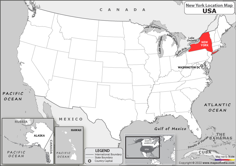
The United States of America is a vast transcontinental country, and New York is firmly established within its mainland territory. It is part of the Mid-Atlantic region, though often also considered part of New England due to historical and cultural ties. This positioning places it on the eastern seaboard of North America, overlooking the Atlantic Ocean.
To the north, New York shares an extensive border with Canada, specifically the provinces of Ontario and Quebec. This international boundary is a significant geographical and economic corridor. To the east, the state is bordered by Vermont, Massachusetts, and a small section of Connecticut. The southern border is shared with New Jersey and Pennsylvania, forming a crucial tri-state area with the metropolitan region of New York City. To the west, New York borders Lake Erie and Lake Ontario, two of the Great Lakes, and the Canadian province of Ontario again along the Niagara River. This access to the Great Lakes system is a vital geographical asset, connecting New York to the interior of the continent and providing extensive freshwater resources and shipping routes.
Proximity to Major Waterways
New York’s geography is profoundly shaped by its relationship with water. The Atlantic Ocean to its southeast provides access to international shipping lanes and influences its climate. The presence of the Hudson River, a major waterway, bisects the state, flowing from the Adirondack Mountains southwards into the Atlantic Ocean. This river has historically been, and continues to be, a crucial transportation artery, facilitating trade and settlement.
The aforementioned Great Lakes also form a significant part of New York’s western boundary. These freshwater bodies are not only a source of natural beauty and recreational opportunities but also integral to the state’s industrial and economic history, enabling large-scale transportation of goods and resources.
The Duality of New York: State and City

A common point of clarification when discussing “New York” is the distinction between New York State and New York City. While both share the same name and are intrinsically linked, they represent different geographical entities, each with its unique characteristics and locations within the state.
New York State: The Broader Territory
New York State encompasses a diverse range of landscapes, from the mountainous terrain of the Adirondack and Catskill Mountains to the rolling hills of Upstate New York and the coastal plains of Long Island. Its sheer size means that different regions within the state experience varying climates and possess distinct geographical features. The capital city of New York, Albany, is located in the eastern part of the state, along the Hudson River. Other significant cities within the state include Buffalo near the Canadian border and Lake Erie, Rochester on the southern shore of Lake Ontario, and Syracuse in the central region.
New York City: The Iconic Metropolis
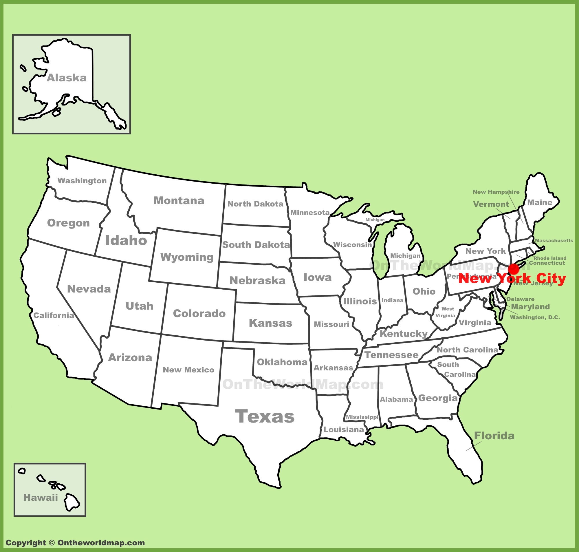
New York City, the state’s most populous and globally recognized urban center, is located at the southeastern tip of New York State. It sits on the mouth of the Hudson River where it meets the Atlantic Ocean. The city is comprised of five distinct boroughs: Manhattan, Brooklyn, Queens, The Bronx, and Staten Island. Each borough possesses its own unique character and geographical setting. Manhattan, a long island itself, is famously situated between the Hudson River and the East River, with Governors Island and Liberty Island (home to the Statue of Liberty) in its harbor. Brooklyn and Queens are located on the westernmost end of Long Island, separated from Manhattan by the East River. The Bronx is the only part of New York City located on the mainland, north of Manhattan. Staten Island, the southernmost borough, is separated from the rest of the city by water.
Navigating New York on the World Map
When looking at a world map, pinpointing New York requires understanding its continental context and then zooming into its specific location. On a global scale, it is situated in the Eastern Hemisphere of the North American continent.
Continental Coordinates
Within North America, New York occupies a significant position on the eastern side. If one were to draw a line across the United States, New York would fall within the upper-right quadrant. Its latitudinal position places it in the temperate zone, contributing to its distinct seasons. Longitudinally, it is on the western side of the Prime Meridian, placing it in the Western Hemisphere.
Regional and National Significance
New York’s location is not just a matter of coordinates; it is intrinsically linked to its influence. Its proximity to Europe via the Atlantic Ocean has historically made it a primary gateway for immigration and international trade. The city of New York remains one of the world’s foremost financial and cultural hubs, its influence radiating globally. The state’s diverse geography, from its urban centers to its natural parks like Niagara Falls State Park, attracts millions of visitors annually, further solidifying its place on the global map of desirable destinations. The interconnectedness of its transportation networks, including major airports like John F. Kennedy International Airport and LaGuardia Airport, as well as its extensive rail and road systems, ensures it remains a central node in global transit.
In conclusion, understanding “Where Is New York On Map?” involves appreciating its position within the United States, its borders with neighboring states and countries, its access to vital waterways, and the crucial distinction between the state and its iconic city. This geographical framework is fundamental to grasping its historical development, economic power, and enduring cultural impact on the world stage.
LifeOutOfTheBox is a participant in the Amazon Services LLC Associates Program, an affiliate advertising program designed to provide a means for sites to earn advertising fees by advertising and linking to Amazon.com. Amazon, the Amazon logo, AmazonSupply, and the AmazonSupply logo are trademarks of Amazon.com, Inc. or its affiliates. As an Amazon Associate we earn affiliate commissions from qualifying purchases.