
For travelers and geography enthusiasts alike, understanding the placement of Oklahoma is the key to unlocking a diverse and underrated slice of the United States. Often referred to as the heart of the country, this state occupies a unique position in the South-Central region, serving as a crossroads where the culture of the Deep South, the Great Plains, and the Southwest converge. Identifying its location on a map is more than a simple exercise in cartography; it is an invitation to explore a landscape defined by rolling prairies, rugged mountains, and a rich tapestry of history.

Geographic Placement and Regional Significance
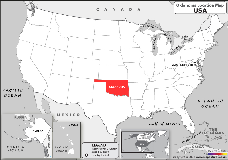
When looking at a map of the United States, Oklahoma is prominently situated north of Texas, east of New Mexico, west of Arkansas and Missouri, and south of Kansas and Colorado. This central location makes the state a frequent thoroughfare for those traveling across the continent, yet its geographic diversity often surprises those who only catch a glimpse of it from the highway.
The Crossroads of the Great Plains and the South
The state serves as a transition zone. The eastern portion of Oklahoma is heavily forested and hilly, sharing the ecological characteristics of the Ozark Mountains and the Ouachita Mountains. In contrast, as one travels westward, the elevation increases and the landscape transitions into the high plains and shortgrass prairies that define much of the Great Plains. This shift makes Oklahoma a fascinating study in environmental variety, housing over ten distinct ecological regions—more per square mile than any other state in the nation.
Accessibility and Transportation Hubs
Because of its central location, Oklahoma has historically functioned as a vital hub for transportation. From the early days of the Chisholm Trail to the legendary Route 66, which cuts a vibrant diagonal path across the state, travel has been deeply ingrained in its identity. Major cities like Oklahoma City and Tulsa are connected by a robust network of interstate highways, making the state an ideal destination for road-trippers navigating between the Atlantic and Pacific coasts.
Key Cultural and Natural Destinations
While its map coordinates are fixed, the experience of Oklahoma is fluid, shifting from urban sophistication to untamed wilderness. Understanding where the state sits on the map helps travelers plan itineraries that capture its multifaceted personality.
The Urban Energy of the Metropolitan Centers
Oklahoma City, the capital, sits squarely in the central part of the state. It has undergone a dramatic transformation in recent decades, with districts like Bricktown offering a bustling nightlife, professional sports, and a picturesque canal district. To the northeast, Tulsa offers a striking architectural contrast with its world-class collection of Art Deco buildings and the massive Gathering Place park, which has redefined urban green spaces. Both cities serve as anchor points for travelers looking to understand the state’s modern development while remaining grounded in its storied past.
Exploring the Untamed Natural Wonders
The geography of Oklahoma is perhaps best experienced in its state and national parks. The Wichita Mountains Wildlife Refuge, located in the southwestern quadrant, is a haven for bison, elk, and longhorn cattle, set against a backdrop of ancient, rugged granite peaks. Further east, the Broken Bow Lake region offers visitors a serene escape into the lush woodlands of the Ouachita National Forest, where crystal-clear waters and towering pines create an atmosphere of quiet reflection far removed from the desert plains of the west.

The Historical and Indigenous Context
The significance of Oklahoma on the US map is inseparable from its history as “Indian Territory.” Long before it became a state in 1907, the land was designated as a destination for dozens of Native American tribes forced to relocate from across the country.
A Legacy of Resilience
Today, 39 federally recognized tribes are headquartered in Oklahoma. This history is honored throughout the state, from the First Americans Museum in Oklahoma City to the various cultural centers and annual powwows held in tribal communities. For the modern visitor, understanding the map of Oklahoma includes acknowledging the deep, enduring influence of these nations on the state’s culture, government, and artistic expression.
Preserving the Past
Beyond the tribal history, the state preserves a legacy of pioneer spirit and the oil boom era. Towns like Guthrie, the state’s first capital, feature some of the best-preserved Victorian architecture in the country. Visiting these locations provides a tangible link to the late 19th and early 20th centuries, allowing travelers to walk the same streets that once hosted land runs and cattle drives.
Travel Tips for Navigating the Sooner State
Navigating a state as wide and diverse as Oklahoma requires a bit of planning. Because it is located in the heart of the Great Plains, weather patterns can be dynamic, and distances between major attractions can be significant.
Best Times for Exploration
Spring and Autumn are arguably the best seasons to visit. During these times, the temperature is moderate, making it ideal for hiking the Tallgrass Prairie Preserve or exploring the historic districts of Tulsa. Spring also brings the lush greenery to the forests of the east, while autumn showcases the vibrant colors of the changing leaves in the Ozark Mountains.
Embracing the Road Trip Culture
Given its location at the intersection of major transit routes, the best way to experience Oklahoma is by car. Following segments of Route 66 allows for a nostalgic journey through neon-lit roadside diners, quirky museums, and Americana landmarks that define the mid-century travel experience. Whether you start in the northern plains or the southern mountain ranges, the state is designed to be traversed, with small towns offering hospitality that feels increasingly rare in larger, more densely populated regions.
Essential Gear and Preparation
Regardless of where you land on the map of Oklahoma, preparation is key. Because the weather can shift rapidly—a common trait for the plains states—layers are essential. Visitors should also be mindful of the expansive distances; ensuring a vehicle is well-maintained and planning for long stretches of open road is standard practice for any seasoned traveler in this part of the country.
In summary, Oklahoma is much more than a flyover state or a simple coordinate on a map. It is a place of profound geographic variety, a cultural melting pot influenced by deep indigenous history, and a destination that rewards those who take the time to traverse its landscapes. From the western hills to the eastern forests, Oklahoma invites exploration, promising that those who venture into its heart will find something truly unique to America.
LifeOutOfTheBox is a participant in the Amazon Services LLC Associates Program, an affiliate advertising program designed to provide a means for sites to earn advertising fees by advertising and linking to Amazon.com. Amazon, the Amazon logo, AmazonSupply, and the AmazonSupply logo are trademarks of Amazon.com, Inc. or its affiliates. As an Amazon Associate we earn affiliate commissions from qualifying purchases.