
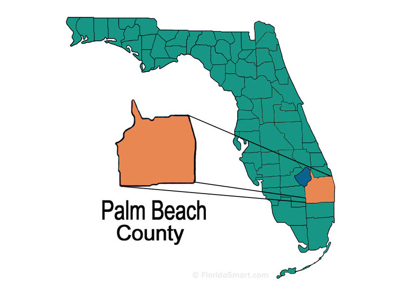
Locating Palm Beach on a map reveals a slender, golden sliver of land nestled between the vast Atlantic Ocean and the serene Lake Worth Lagoon. Situated on the southeastern coast of Florida, this iconic town is the crown jewel of Palm Beach County. For travelers and geography enthusiasts alike, understanding the layout of this region is essential for appreciating its unique blend of historical significance, architectural beauty, and natural splendor. While often confused with its larger neighbor, West Palm Beach, the town of Palm Beach maintains a distinct identity defined by its island geography and its status as a premier global destination.

Navigating the Geography of the Island and Beyond
To truly answer the question of where Palm Beach is, one must look at the barrier island system that protects the Florida mainland. The town is located approximately 65 miles north of Miami and 45 miles north of Fort Lauderdale. It sits at a point where the Gulf Stream current flows closest to the United States coastline, bringing with it temperate waters and a lush, tropical climate that has defined the Sunshine State for centuries.
The Island vs. The Mainland
When looking at a map, the physical separation between Palm Beach and the mainland is immediate. The Lake Worth Lagoon, which is part of the Intracoastal Waterway, serves as a nautical border. Three main bridges connect the island to West Palm Beach: the Flagler Memorial Bridge to the north, the Royal Park Bridge in the center, and the Southern Boulevard Bridge to the south. This separation is more than just geographical; it creates an atmosphere of exclusivity and tranquility that is rare in modern travel.
The island itself is approximately 16 miles long but only about a half-mile wide at its broadest point. This narrow geometry means that you are never more than a few minutes’ walk from either the rhythmic waves of the Atlantic Ocean or the calm, sunset-viewing docks of the Intracoastal Waterway.
Defining the Boundaries of Palm Beach County
While the town is the historic heart, Palm Beach County covers a massive 2,000 square miles, making it larger than the states of Rhode Island and Delaware. To the west, the county stretches toward the Everglades and the shores of Lake Okeechobee. To the north, it is bordered by Martin County, and to the south, it meets Broward County. Understanding this broader map helps travelers realize that while they may stay in the quiet corridors of the island, a world of ecological diversity and urban excitement is just a short drive away.
Iconic Landmarks to Locate on Your Itinerary
A map of Palm Beach is dotted with landmarks that tell the story of the Gilded Age and the visionary development of Henry Flagler. These sites are not just points on a grid; they are the cultural pillars of the Florida experience.
The Historic Grandeur of The Breakers and Whitehall
No exploration of this area is complete without visiting The Breakers. Originally opened in 1896 by Henry Flagler, this legendary resort occupies a prime oceanfront position. Its Italian Renaissance architecture and sprawling grounds are a testament to the opulence of the early 20th century. Just a short distance away lies Whitehall, now known as the Henry Morrison Flagler Museum. This 75-room mansion was built as a wedding present for Flagler’s wife and stands as one of the finest examples of the Beaux Arts style in the United States.
For those interested in spiritual and architectural history, the Bethesda-by-the-Sea Episcopal church and the Royal Poinciana Chapel offer stunning grounds and Gothic revival details. These structures are often used as navigational markers for those walking the scenic Lake Trail, a paved path that runs along the western edge of the island, offering unobstructed views of the West Palm Beach skyline across the water.
The Luxury Corridor of Worth Avenue
If you center your map on the southern portion of the town’s commercial district, you will find Worth Avenue. Often compared to Rodeo Drive in Beverly Hills or Champs Elysees in Paris, this three-block stretch is a world-renowned shopping and dining destination. The architecture here is characterized by Mediterranean Revival influences, with hidden courtyards called “vias” that lead visitors away from the main thoroughfare into enchanting spaces filled with bougainvillea and fountains. At the end of the avenue, the Worth Avenue Clock Tower stands as a popular landmark for photographs, marking the entrance to the public beach.

Natural Wonders and Outdoor Exploration
Beyond the manicured hedges and luxury boutiques, the map of Palm Beach includes significant natural sites that offer a different perspective on the Florida landscape.
Coastal Escapes and Wildlife Preserves
To the north of the main town lies MacArthur Beach State Park. This park is a vital environmental preserve, offering a glimpse of what the island looked like before development. Here, visitors can kayak through mangroves or snorkel in the crystal-clear waters of the Atlantic Ocean. The park serves as a nesting ground for sea turtles, a spectacle that draws nature lovers from around the world.
In the middle of the Lake Worth Lagoon is Peanut Island. Accessible only by boat or ferry, this man-made island is a favorite for weekend boaters and snorkelers. It is also home to a historic John F Kennedy bunker, built during the Cold War as a secret shelter for the president during his stays at the family’s Palm Beach estate.
Navigating the Waterways
The Intracoastal Waterway is the lifeblood of the region’s maritime culture. For those navigating by boat, the map is defined by inlets and marinas. The Lake Worth Inlet provides deep-water access for large yachts and cargo ships, while smaller vessels weave between the docks of the Palm Beach Yacht Club and various private piers. Observing the sunset from a boat on the lagoon offers one of the most comprehensive views of the island’s geographical layout, highlighting the density of the palms and the proximity of the estates to the water.
Regional Connectivity and Travel Logistics
Understanding where Palm Beach is also involves knowing how to get there and how it connects to the rest of South Florida.
Reaching the Destination
The primary gateway for air travel is the Palm Beach International Airport, located just west of the island in West Palm Beach. For those traveling by rail, the Brightline high-speed train connects the region to Miami, Aventura, Fort Lauderdale, and Orlando, making it easier than ever for tourists to include a visit to the island in a broader Florida itinerary.
Road travelers typically arrive via I-95 or Florida’s Turnpike, both of which run north-to-south through the county. From these major highways, several east-west roads lead directly to the bridges that cross onto the island. Once on the island, A1A (known locally as Ocean Boulevard) serves as the primary scenic route, hugging the coastline and providing some of the most beautiful driving views in the United States.
Exploring Neighboring Coastal Cities
While Palm Beach is a destination unto itself, its location makes it an ideal hub for exploring other nearby cities. To the north, Jupiter is famous for the Jupiter Inlet Lighthouse and its rugged beaches. To the south, Delray Beach offers a vibrant nightlife scene centered around Atlantic Avenue. Further south still is Boca Raton, known for its Mediterranean architecture and luxury shopping at Mizner Park.
Across the water, West Palm Beach provides the urban counterpart to the island’s resort atmosphere. Visitors often cross the bridge to explore the Norton Museum of Art, the Kravis Center for the Performing Arts, and the bustling districts of Rosemary Square and Clematis Street. Families often head slightly inland to visit the Palm Beach Zoo or the Cox Science Center and Aquarium.
By understanding the Palm Beach map, travelers can better appreciate the strategic and beautiful location of this historic town. Whether you are looking for the prestige of Worth Avenue, the history of The Breakers, or the natural beauty of the Atlantic Ocean, knowing exactly where this destination sits on the Florida coast is the first step toward an unforgettable experience.
LifeOutOfTheBox is a participant in the Amazon Services LLC Associates Program, an affiliate advertising program designed to provide a means for sites to earn advertising fees by advertising and linking to Amazon.com. Amazon, the Amazon logo, AmazonSupply, and the AmazonSupply logo are trademarks of Amazon.com, Inc. or its affiliates. As an Amazon Associate we earn affiliate commissions from qualifying purchases.