
Punta Gorda, Florida, a name that often evokes images of sun-drenched coastlines and laid-back charm, holds a significant place on the map of Southwest Florida. For travelers contemplating a visit to the Sunshine State, pinpointing the exact location of this quaint city is the crucial first step in planning an unforgettable journey. More than just a dot on a chart, Punta Gorda’s geographic placement is integral to understanding its unique character, its accessibility, and the wealth of experiences it offers. Nestled at the confluence of the Peace River and Charlotte Harbor, this city in Charlotte County serves as a gateway to both the tranquil waters of the Gulf of Mexico and the vibrant natural landscapes that define Florida’s western coast. Its strategic position makes it an ideal base for exploring a diverse array of attractions, from pristine beaches and aquatic adventures to historic downtown areas and ecological preserves. Understanding “where” Punta Gorda is on a map translates directly into understanding “why” it is a destination worth exploring, revealing the logistical ease of reaching it and the array of travel experiences that unfold once you arrive. This guide will meticulously chart Punta Gorda’s location, illuminate its accessibility, and underscore how its geography shapes its identity as a premier travel destination.
Unveiling Punta Gorda’s Geographic Charm
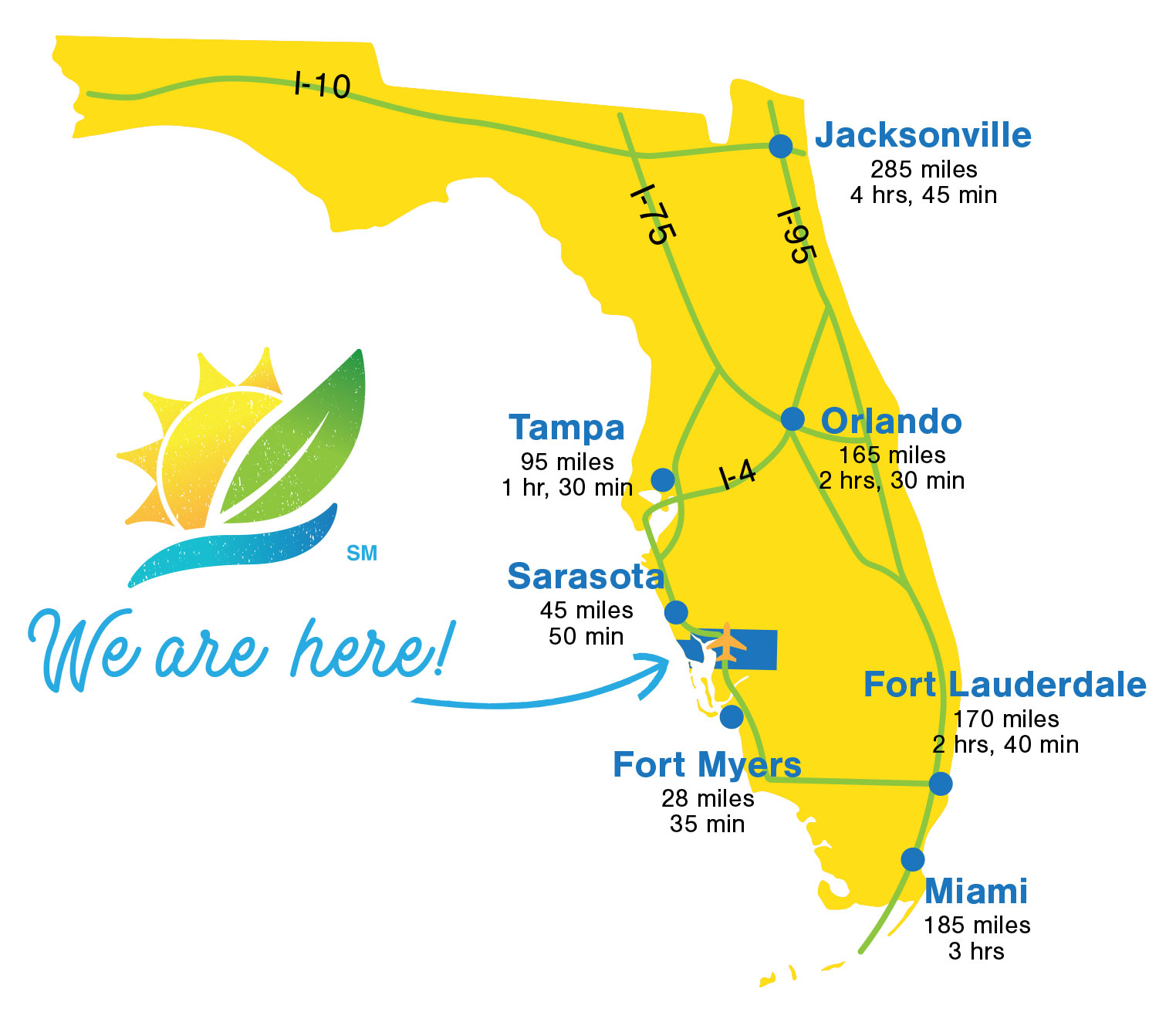
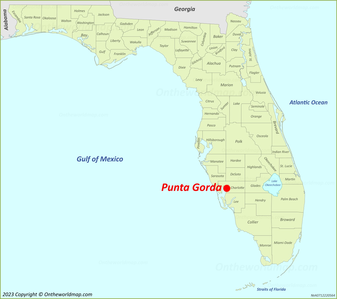
At its heart, Punta Gorda is a quintessential Florida coastal city, strategically positioned to offer both serene waterfront living and convenient access to major regional hubs. To locate it precisely on a map, one would draw their gaze to the southwestern quadrant of the Florida peninsula.
The Confluence of River and Gulf
Punta Gorda is uniquely situated at the mouth of the Peace River, where its freshwater currents merge with the brackish expanse of Charlotte Harbor. Charlotte Harbor itself is the second-largest open-water estuary in Florida, a vast body of water that directly connects to the Gulf of Mexico. This specific location provides Punta Gorda with its defining character: a city intrinsically linked to its waterways. The downtown area and many residential neighborhoods are built along these shores, offering unparalleled access to boating, fishing, and myriad other water-based activities. The gentle lapping of waves and the expansive views across the harbor are not merely scenic backdrops but are central to the city’s lifestyle and appeal to travelers seeking a coastal experience.
Part of Southwest Florida’s Tapestry
Geographically, Punta Gorda is an integral component of the broader Southwest Florida region. This area encompasses a collection of vibrant cities and towns, including Fort Myers to the south, and Sarasota and Bradenton to the north. Being nestled within this dynamic region means Punta Gorda benefits from its proximity to larger metropolitan centers while retaining its distinct, small-town charm. It offers a quieter, more relaxed alternative to some of its bustling neighbors, yet remains close enough for day trips to more crowded attractions or for accessing larger airports and services. This balance is a significant draw for many visitors who seek both tranquility and convenience. The area’s subtropical climate, characterized by warm, humid summers and mild, dry winters, is also a direct consequence of its southern Florida latitude, making it a popular escape for those fleeing colder climes.
Getting to Punta Gorda: Accessibility and Transportation
Understanding Punta Gorda’s position on the map is critical, but knowing how to get there completes the picture for any prospective traveler. The city’s location has endowed it with excellent connectivity, making it relatively easy to reach by various modes of transport.
By Air: Gateways to the Gulf Coast
For air travelers, Punta Gorda is serviced directly by the Punta Gorda Airport (PGD). This regional airport has grown significantly in recent years, primarily due to its popularity with budget airlines, offering direct flights to numerous cities across the eastern and central United States. The convenience of flying directly into Punta Gorda cannot be overstated, as it eliminates the need for long drives from larger, more congested airports.
However, for those flying from international destinations or seeking broader flight options, Punta Gorda’s location also provides easy access to larger international airports. The Southwest Florida International Airport (RSW) in Fort Myers is approximately a 40-minute drive south, offering a wider array of domestic and international flights. To the north, the Sarasota-Bradenton International Airport (SRQ) in Sarasota is about an hour’s drive away, providing yet another accessible option. This multi-airport accessibility provides travelers with flexibility in flight selection and pricing.
By Road: Navigating Florida’s Highways
Punta Gorda’s location on major transportation arteries makes it highly accessible by car. The most prominent route is Interstate 75 (I-75), which runs directly through the eastern part of Punta Gorda and Charlotte County. This major north-south highway connects Punta Gorda to Tampa and Sarasota to the north, and Fort Myers, Naples, and even the Everglades to the south.
Additionally, U.S. Route 41, famously known as the Tamiami Trail, traverses directly through the heart of Punta Gorda. This historic highway runs parallel to I-75 and offers a more scenic, often slower-paced drive through various towns and commercial districts. For those embarking on a Florida road trip, Punta Gorda’s position makes it a natural stopover or a convenient starting point for exploring the Gulf Coast. From major cities like Miami or Orlando, the drive typically ranges from 2.5 to 3 hours, making it an easy day trip or weekend getaway destination.
The Allure of Punta Gorda: What Makes This Florida Gem a Must-Visit
The answer to “Where is Punta Gorda on a map?” is intrinsically linked to “Why visit Punta Gorda?” Its geographic attributes directly contribute to its identity as a compelling travel destination, offering a diverse array of attractions rooted in its natural environment and historical context.
Waterfront Wonders and Aquatic Adventures
Being situated on Charlotte Harbor and the Peace River means Punta Gorda is a paradise for water enthusiasts. Travelers can indulge in deep-sea fishing charters into the Gulf of Mexico, calmer inshore fishing in the harbor, or scenic boat tours that often lead to dolphin sightings and explorations of mangrove tunnels. Kayaking and paddleboarding along the Peace River offer a tranquil way to experience Florida’s unique ecosystems. The city’s numerous marinas, including the prominent Fisherman’s Village and Burnt Store Marina, provide ample opportunities for boat rentals, charters, and dining with a view. Its proximity to barrier islands like Gasparilla Island and the quaint town of Boca Grande also means pristine, less crowded beaches are just a short boat ride or drive away, offering a contrast to the bustling sands of larger Florida beach cities.
Historic Charm and Cultural Richness
Beyond its waterways, Punta Gorda’s downtown area, known as the Historic District, offers a journey back in time. The city has done an exemplary job of preserving its heritage, evident in its beautifully restored buildings, tree-lined streets, and vibrant public art scene. Walking or biking through downtown reveals murals, sculptures, and galleries that tell the story of the city’s past and present. The local farmer’s market, held weekly, is a hub of community activity, showcasing local produce, crafts, and culinary delights. Parks like Gilchrist Park, Laishley Park, and Ponce de Leon Park provide expansive green spaces for relaxation, recreation, and often host outdoor concerts and festivals. This blend of natural beauty and cultural engagement creates a multifaceted travel experience.
Navigating Punta Gorda: Local Exploration and Surroundings
Once you’ve arrived, Punta Gorda’s manageable size and well-planned layout make local exploration a breeze. Its location also positions it perfectly for venturing out to discover surrounding gems.
Exploring the City’s Heart
Within Punta Gorda itself, the compact downtown core is highly walkable and bike-friendly. Renting a bicycle is a popular way to explore the various parks, waterfront pathways, and the Linear Park Pathway system, which offers miles of scenic routes. The city’s design, with its emphasis on public spaces and waterfront access, encourages visitors to linger and soak in the atmosphere. From the shops and restaurants of Fisherman’s Village to the art galleries and boutiques in the Historic District, every corner of Punta Gorda feels inviting and easily accessible.
Day Trips to Nearby Treasures
Punta Gorda’s central location in Charlotte County makes it an excellent base for day trips. To the north, the cities of Port Charlotte and Englewood offer additional dining, shopping, and beach access. A short drive east takes you to the unique, master-planned community of Babcock Ranch and the expansive Babcock Ranch Preserve, where eco-tours provide glimpses of Florida’s wildlife, including alligators and various bird species, in their natural habitat. Southward, the world-renowned beaches of Sanibel Island and Captiva Island, famous for their shelling, are within a reasonable driving distance, offering a different coastal experience. Even the natural beauty of Myakka River State Park, one of Florida’s oldest and largest state parks, is less than an hour’s drive north. This geographical advantage allows travelers to diversify their itinerary without having to relocate, maximizing their Florida experience.
Planning Your Trip: Essential Location-Based Considerations
Finally, knowing where Punta Gorda is on the map empowers travelers to make informed decisions about their visit, from the best time to go to what to pack.
Climate and Best Time to Visit
Punta Gorda’s position in Southwest Florida means it enjoys a subtropical climate. The peak travel season typically runs from November through April, when temperatures are mild and pleasant, humidity is low, and sunshine is abundant. This period is ideal for outdoor activities, beach visits, and exploring the city on foot or by bike. Summers (May to October) are hot and humid, with frequent afternoon thunderstorms, characteristic of Florida’s wet season. While travel during this time offers lower prices and fewer crowds, visitors should be prepared for the heat and plan activities accordingly, focusing on indoor attractions or early morning/late afternoon excursions. Hurricane season officially runs from June 1 to November 30, a geographical reality for all coastal Florida destinations, and travel insurance is always a wise consideration during these months.

Preparing for the Florida Lifestyle
Given its coastal location, packing essentials for Punta Gorda should include light, breathable clothing, swimwear, sun protection (hats, sunglasses, high-SPF sunscreen), and comfortable walking shoes. Insect repellent can be useful, especially during warmer months or when exploring natural areas. Due to its proximity to the water, a camera with waterproof capabilities might be a great addition to capture the stunning scenery and marine life. Understanding Punta Gorda’s location helps travelers anticipate the kind of environment they will encounter and prepare for a seamless and enjoyable experience in this charming Florida city.
In conclusion, “Where is Punta Gorda, Florida on a map?” is more than a simple geographical query. It’s the key to unlocking a destination that offers a rich tapestry of experiences, shaped by its unique position on the Peace River and Charlotte Harbor. Its accessibility by air and road, combined with its intrinsic natural beauty and historic charm, firmly establishes Punta Gorda as a distinguished and desirable stop for any traveler seeking the authentic allure of Southwest Florida.
LifeOutOfTheBox is a participant in the Amazon Services LLC Associates Program, an affiliate advertising program designed to provide a means for sites to earn advertising fees by advertising and linking to Amazon.com. Amazon, the Amazon logo, AmazonSupply, and the AmazonSupply logo are trademarks of Amazon.com, Inc. or its affiliates. As an Amazon Associate we earn affiliate commissions from qualifying purchases.