
The Dynamic Geology of California
California, a land of unparalleled beauty and diversity, from sun-drenched beaches to towering mountain ranges, owes much of its iconic landscape to a dramatic and continuous geological process. Far from being static, the Golden State is a vibrant canvas perpetually sculpted by the immense forces of plate tectonics. Understanding “where the California fault line is” is not merely about locating a geographical feature; it’s about grasping the very essence of this dynamic landmark and the powerful mechanisms that define its natural character.
A Land Shaped by Tectonics
The distinctive features of California—its coastal mountain ranges, fertile valleys, and even the desert expanses—are direct consequences of the ongoing collision and sliding of colossal tectonic plates beneath the Earth’s surface. This relentless geological activity makes California one of the most seismically active regions in the world, a truly living landscape where the ground itself is in constant, albeit often imperceptible, motion. The presence of numerous fault lines is a testament to this deep-seated geological narrative, making the entire state a fascinating landmark of planetary forces at work.
Understanding Plate Tectonics
At the heart of California’s geological story is the boundary between two of Earth’s largest tectonic plates: the Pacific Plate and the North American Plate. Unlike boundaries where plates crash head-on (convergent) or pull apart (divergent), the California margin is primarily a transform boundary. Here, these massive crustal slabs grind past each other horizontally. The Pacific Plate, which carries much of California’s coastline and moves northwestward, is shearing past the North American Plate, which moves southwestward. This relative motion, averaging a few centimeters per year, is accommodated by a complex network of faults, with the most famous among them being the San Andreas Fault.
The Iconic San Andreas Fault: California’s Main Arterial Fault
When people ask about “the California fault line,” they are almost invariably referring to the San Andreas Fault. This legendary geological scar is the primary expression of the Pacific and North American Plate boundary in California, a monumental natural landmark that has shaped the state’s physical and historical landscape.
Tracing the Path
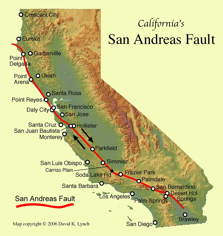
The San Andreas Fault is an immense feature, stretching approximately 800 miles (1,300 kilometers) through the length of California. Its journey begins in the south near the Salton Sea, a large, shallow, saline lake in Southern California. From there, it snakes northwestward, traversing deserts, mountain ranges, vast agricultural lands, and dense urban areas, before finally heading offshore near Cape Mendocino in Northern California. It effectively divides California into two distinct geological blocks: land west of the fault is on the Pacific Plate, while land east of it is on the North American Plate.
Key Segments and Their Characteristics
The San Andreas Fault is not a single, continuous, uniform crack but rather a series of segments, each exhibiting different behaviors. This segmentation is a crucial aspect of understanding its nature as a landmark.
Southern California Segment
The southern section of the San Andreas Fault, extending roughly from the Salton Sea through the Coachella Valley and along the northern flanks of the San Bernardino Mountains into the Mojave Desert, is largely “locked.” This means the two sides of the fault are stuck, accumulating enormous stress as the plates continue their relentless movement. This segment has not experienced a major earthquake in over 300 years, making it a subject of intense scientific scrutiny and a significant natural landmark for geological study.
Central California Segment
Further north, in Central California, the fault behaves differently. Between Parkfield and the Carrizo Plain, the fault is characterized by “creep,” where the two sides slowly and continuously slide past each other without large seismic events. This section provides a fascinating natural laboratory for geologists, who have installed extensive monitoring equipment here, making places like Parkfield a unique scientific landmark. The Carrizo Plain offers some of the most visible and dramatic surface expressions of the fault.
Northern California Segment
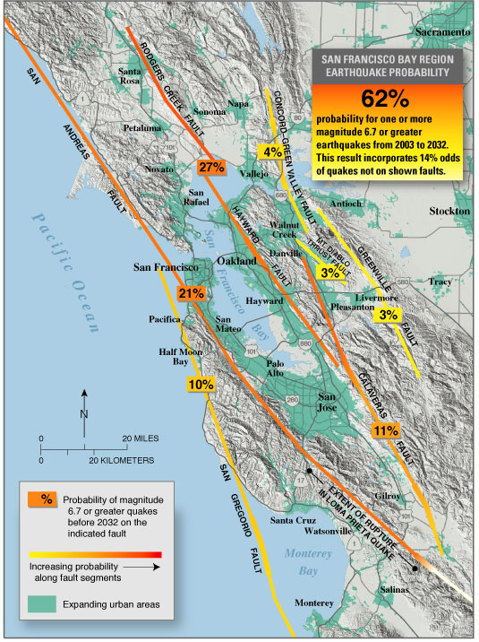
In Northern California, particularly around the Bay Area, the San Andreas Fault again becomes largely locked. This segment was responsible for the devastating 1906 San Francisco Earthquake. The fault line runs offshore for much of this section but is famously visible at Point Reyes, where visitors can stand directly on the fault trace and observe its impact on the landscape.
Visible Evidence: Exploring the Fault
For those interested in witnessing this incredible natural landmark firsthand, several sites offer exceptional views of the San Andreas Fault. In the Carrizo Plain National Monument, about 100 miles northwest of Los Angeles, the fault appears as a prominent linear depression, or “rift valley,” cutting across the landscape. Features like offset streams and sag ponds clearly illustrate the fault’s strike-slip motion. The Palmdale area in Southern California also offers access points for observation, as does the aforementioned Point Reyes National Seashore in the north. These locations serve as remarkable natural landmarks, offering tangible proof of Earth’s dynamic processes.
Beyond the San Andreas: A Network of Faults
While the San Andreas Fault is the most renowned, it is by no means the only significant fault line in California. The state is crisscrossed by an intricate web of active faults, each contributing to the region’s complex seismic profile and forming a broader landscape of geological landmarks.
Interconnected Systems
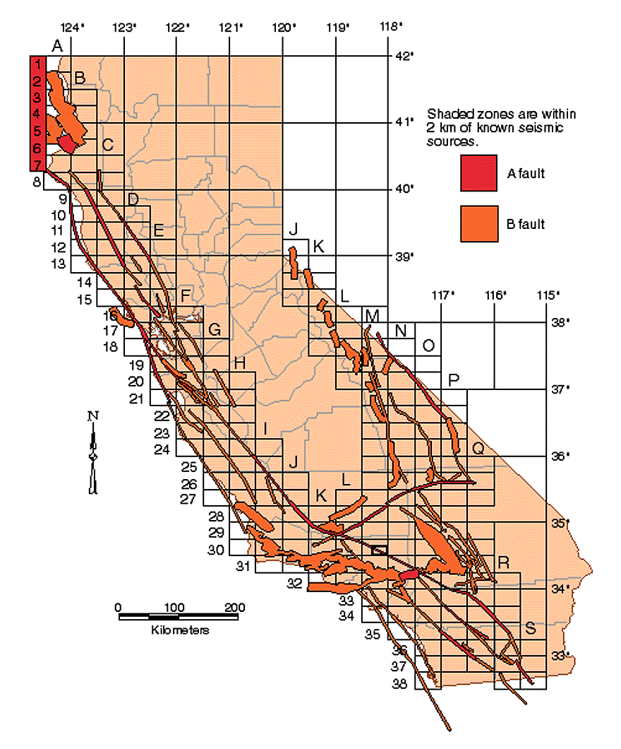
The movement of the Pacific and North American Plates isn’t solely accommodated by the San Andreas Fault. Instead, the stress is distributed across an extensive system of subsidiary faults that run parallel to or branch off from the main fault. This network is a crucial aspect of California’s geological identity, demonstrating how deeply the state is characterized by these subterranean features.
Major Subsidiary Faults
Several other faults play critical roles in California’s seismic activity, each a significant landmark in its own right for understanding the state’s geology:
- Hayward Fault: Located in the East Bay Area, this fault runs through densely populated areas, making it one of the most hazardous in California. It’s known for its significant creep, visible in offset curbs and buildings, making it a striking urban geological landmark.
- San Jacinto Fault: Branching off the San Andreas Fault in Southern California, this fault is one of the most active in the state, regularly producing moderate to large earthquakes.
- Garlock Fault: This massive left-lateral strike-slip fault (meaning the opposite direction of the San Andreas Fault’s right-lateral movement) runs for approximately 160 miles through the Mojave Desert, essentially perpendicular to the San Andreas.
- Newport-Inglewood Fault: A series of right-lateral strike-slip faults that extend from offshore Newport Beach through the Los Angeles basin, responsible for the 1933 Long Beach earthquake.
Blind Thrust Faults and Their Significance
Adding another layer of complexity to California’s fault landscape are “blind thrust faults.” These are faults that do not break the surface, remaining hidden beneath layers of rock and sediment. Despite being invisible, they can generate powerful earthquakes. The 1994 Northridge Earthquake, for instance, was caused by a previously unknown blind thrust fault beneath the San Fernando Valley near Los Angeles. These hidden geological features, though unseen, are crucial elements of California’s dynamic natural landmark status.
The Fault as a Natural Landmark and Its Impact
The California fault lines, particularly the San Andreas Fault, are more than just geological boundaries; they are monumental natural landmarks that have profoundly shaped the physical environment and historical narrative of the state.
Shaping California’s Landscape
The continuous movement along these fault lines has created many of California’s most distinctive topographical features. The linear valleys and mountain ranges that run parallel to the San Andreas Fault are direct results of tectonic forces. The San Gabriel and San Bernardino Mountains in the south, the Transverse Ranges, and the coastal ranges further north all bear the indelible mark of this geological activity. These fault-created landscapes are unique ecosystems, home to specific flora and fauna adapted to the conditions, forming ecological landmarks that are intrinsically linked to the underlying geology.
Historical Seismic Events
The fault lines are also markers of significant historical events. The 1906 San Francisco Earthquake, caused by a rupture on the Northern California segment of the San Andreas Fault, remains one of the most destructive natural disasters in United States history. Other notable seismic events, such as the 1989 Loma Prieta Earthquake near Santa Cruz and the 1994 Northridge Earthquake in Los Angeles, underscore the continuous activity of this vast fault system. These events, while tragic, are integral to the identity of California as a geological landmark, reminding its inhabitants and visitors of the Earth’s raw power.
Living with the Dynamic Earth
Understanding where the California fault line is, and the broader network of faults, is fundamental to appreciating the state as a vibrant, living landmark. Scientists continuously monitor these fault lines, using GPS, seismic sensors, and other technologies to track movements and better understand earthquake potential. This ongoing scientific endeavor makes the fault lines not only natural wonders but also centers of crucial research, drawing geologists and researchers from around the globe to study this unparalleled geological laboratory. California stands as a testament to the dynamic nature of our planet, a place where the ground beneath our feet is a constant, evolving landmark.
LifeOutOfTheBox is a participant in the Amazon Services LLC Associates Program, an affiliate advertising program designed to provide a means for sites to earn advertising fees by advertising and linking to Amazon.com. Amazon, the Amazon logo, AmazonSupply, and the AmazonSupply logo are trademarks of Amazon.com, Inc. or its affiliates. As an Amazon Associate we earn affiliate commissions from qualifying purchases.