
The question of why Alaska, a vast and remote northern territory, belongs to the United States rather than its immediate neighbor, Canada, delves deep into the annals of geopolitical maneuvering, imperial ambitions, and the sheer luck of timing. This unique historical trajectory has shaped Alaska into the distinctive American landmark it is today, a place of unparalleled natural beauty and strategic significance. Understanding its sovereignty requires a journey back to the era of global exploration and the strategic calculations of empires.
A Frozen Frontier: Early Explorations and Claims
The landmass now known as Alaska was not always a blank slate on the map for European powers. Indigenous peoples had thrived there for millennia, developing rich cultures adapted to its challenging environments. However, the 18th century saw the arrival of European explorers, primarily from Russia, seeking new territories and valuable resources.

Russian Presence and the Fur Trade
The first documented European discovery of Alaska is generally credited to a Russian expedition led by Vitus Bering in 1741. This discovery opened the floodgates for Russian fur traders, who established settlements along the coast, driven by the lucrative trade in sea otter pelts. The Russian-American Company, chartered in 1799, became the primary instrument of Russian colonial expansion, controlling trade, mining, and all other enterprises in what became known as Russian America. Outposts like Sitka (then New Archangel) served as the administrative and economic hub of this vast, distant territory.
Despite the initial successes, governing and provisioning Russian America proved increasingly difficult and expensive for the Russian Empire. The sheer distance from St. Petersburg, the declining fur populations due to overhunting, and the logistical nightmares of maintaining a presence across the Pacific Ocean made the venture less profitable over time. Moreover, Russia found itself financially strained after the Crimean War (1853-1856) and viewed its North American possession as a strategic liability, vulnerable to seizure by rival powers like Great Britain (which controlled neighboring Canada).
Shifting European Interests
While Russia had a foothold, other European powers, particularly Great Britain and the United States, also had burgeoning interests in North America. British explorers and traders, operating through entities like the Hudson’s Bay Company, were pushing westward across what is now Canada. The proximity of British North America (later Canada) to Russian America naturally brought the two spheres of influence into contact, leading to agreements like the Anglo-Russian Convention of 1825 that defined much of the present-day southeastern Alaska-Canada border. Despite these agreements, the underlying tension and potential for conflict remained. Russia’s desire to prevent Alaska from falling into British hands played a significant role in its decision to sell.
The Alaskan Purchase: Seward’s Folly or Strategic Masterstroke?
The mid-19th century saw a dramatic shift in the future of Alaska. Facing internal financial woes and strategic concerns, Russia decided that selling Alaska was the most prudent course of action. The obvious buyer, given the geopolitical climate, was the United States.
The Treaty of Cession
Negotiations between Russia and the United States began in earnest after the American Civil War. Tsar Alexander II instructed his minister to the U.S., Baron Eduard de Stoeckl, to negotiate with U.S. Secretary of State William Seward. Seward, a staunch expansionist, recognized the immense strategic value of Alaska, even though many of his contemporaries did not.
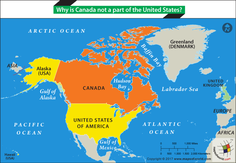
On March 30, 1867, the two nations signed the Treaty of Cession in Washington, D.C., wherein Russia agreed to sell Alaska to the United States for $7.2 million. This translates to roughly two cents per acre for an estimated 586,412 square miles (1,518,800 square kilometers) of land. The formal transfer of sovereignty took place on October 18, 1867, in Sitka, where the Russian flag was lowered, and the American flag was raised. This act definitively placed Alaska within the American domain, preventing it from ever becoming part of the nascent Canadian confederation, which was formed just months later in July 1867.
Immediate Reactions and Long-Term Vision
Initially, the purchase was met with widespread skepticism and ridicule in the U.S. press, earning it monikers like “Seward’s Folly,” “Seward’s Icebox,” and “Walrussia.” Critics questioned the value of acquiring such a remote, icy, and seemingly barren land. However, Seward and his supporters possessed a farsighted vision. They understood Alaska’s potential for natural resources (fisheries, timber, minerals) and its strategic importance for trade routes to Asia and defense in the Pacific.
The subsequent discoveries of gold during the Klondike Gold Rush in the late 19th century, followed by vast oil reserves in the 20th century, unequivocally vindicated Seward’s purchase, proving it to be one of the greatest real estate deals in history. The acquisition removed a European rival from North America’s doorstep and extended American territory significantly, shaping the geopolitical landscape of the continent for generations to come.
Geographical Significance and Border Delimitations
Alaska’s vast geography and its position at the northwestern extremity of the North American continent were crucial factors in its acquisition and its eventual status as a U.S. state. Its complex border with Canada is a direct result of these historical negotiations.
Defining the U.S.-Canada Boundary
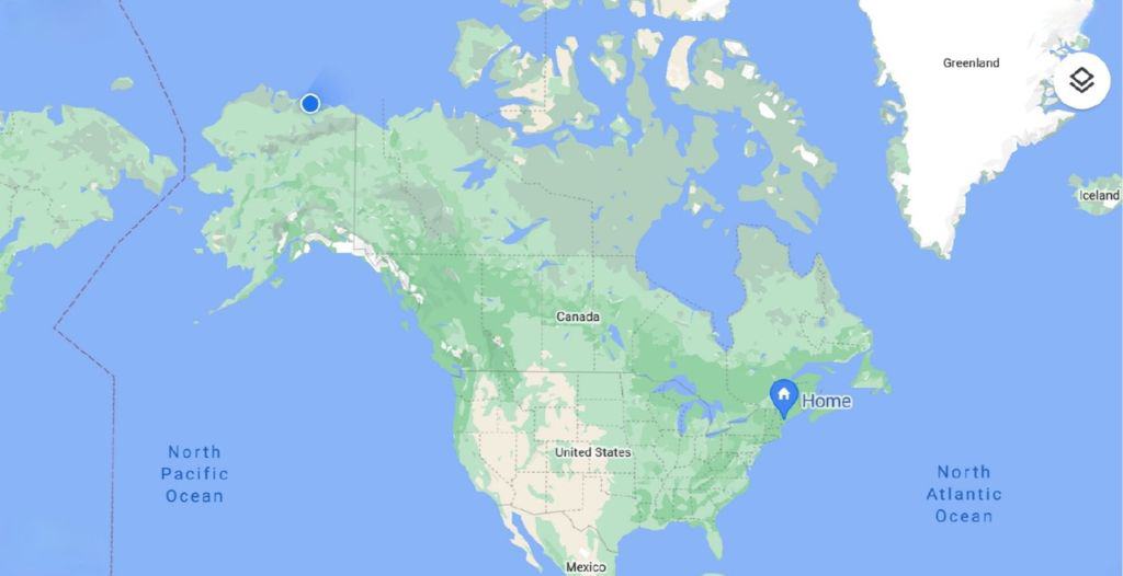
The boundary between Alaska and Canada is largely based on the aforementioned Anglo-Russian Convention of 1825, which the United States inherited upon purchasing Alaska. This treaty defined the border mostly along the 141st meridian west for the northern section, separating Alaska from the Yukon Territory. However, the border along the southeastern “panhandle” region, adjacent to British Columbia, was more ambiguous.
The 1825 treaty stipulated that the border would run along the crest of mountains parallel to the coast, but if such mountains were more than ten leagues (about 56 kilometers) from the ocean, the boundary would be fixed at that distance from the coast. This ambiguity led to the Alaska Boundary Dispute at the turn of the 20th century, particularly exacerbated by the Klondike Gold Rush, which brought immense value to the disputed coastal inlets providing access to the goldfields. An international tribunal finally settled the dispute in 1903, largely in favor of the United States, solidifying the unique panhandle shape of southeastern Alaska and confirming its American identity.
Natural Resources and Strategic Value
Beyond its boundaries, Alaska’s sheer scale and natural endowments have shaped its status. It is the largest state in the U.S. by area, boasting diverse ecosystems from temperate rainforests to Arctic tundra. Its strategic location, bridging the Pacific and Arctic Oceans and its proximity to Russia across the Bering Strait, has consistently underscored its value, especially during the Cold War.
The vast natural resources—rich fisheries, immense oil and gas reserves, and diverse minerals—have transformed Alaska from a perceived “icebox” into a vital economic engine. Iconic natural landmarks like Mount Denali, the highest peak in North America, and the extensive wilderness areas attract global attention, further cementing its unique place within the United States.
The Legacy of Sovereignty: Alaska’s Enduring American Identity
Alaska’s integration into the American fabric was a gradual process, but one that has profoundly shaped its cultural, political, and economic landscape.
Statehood and Modern Development
Following its purchase, Alaska was administered first by the military, then as a district, and finally as an organized territory. The discovery of gold, the development of commercial fishing, and later the exploitation of oil and gas brought waves of settlers and investment. After decades of advocacy, Alaska achieved statehood on January 3, 1959, becoming the 49th state of the United States. This momentous event fully cemented its American identity, granting its residents full political representation and autonomy. Major cities like Anchorage, Fairbanks, and the capital, Juneau, grew into modern hubs, serving as gateways to the vast wilderness and centers for resource extraction and tourism.
Cultural and Economic Ties to the Lower 48
Today, Alaska’s ties to the “Lower 48” are extensive and multifaceted. Economically, its massive oil and gas industry, sustainable fisheries, and burgeoning tourism sector are deeply integrated into the national economy. Culturally, while Alaska retains a distinct frontier spirit and a strong connection to its Indigenous heritage, it shares the broader cultural touchstones and governance structures of the United States.
The very notion of Alaska as a prominent American landmark—a symbol of wilderness, resilience, and untapped potential—is a direct consequence of that fateful transaction in 1867. Its historical journey from a Russian outpost to a vital U.S. state offers a compelling narrative of how geopolitical decisions can forever alter the course of nations and define the identity of an iconic land. The absence of a Canadian claim to this territory is not a matter of proximity, but of a specific moment in history when a farsighted American Secretary of State saw value where others saw only ice.
LifeOutOfTheBox is a participant in the Amazon Services LLC Associates Program, an affiliate advertising program designed to provide a means for sites to earn advertising fees by advertising and linking to Amazon.com. Amazon, the Amazon logo, AmazonSupply, and the AmazonSupply logo are trademarks of Amazon.com, Inc. or its affiliates. As an Amazon Associate we earn affiliate commissions from qualifying purchases.