
The geographic profile of the United States is defined by several distinctive shapes, from the massive block of Texas to the jagged coastline of Maine. However, few regions possess a name as descriptive and visually intuitive as the Florida Panhandle. Stretching across the northwestern portion of Florida, this narrow strip of land is bordered by Alabama to the north and west, Georgia to the north, and the Gulf of Mexico to the south. To understand why it is called the “Panhandle,” one must look at the intersection of cartography, 18th-century colonial politics, and the unique geological landmarks that define this stretch of the North America coastline.

The Cartographic Origin of the “Panhandle” Name
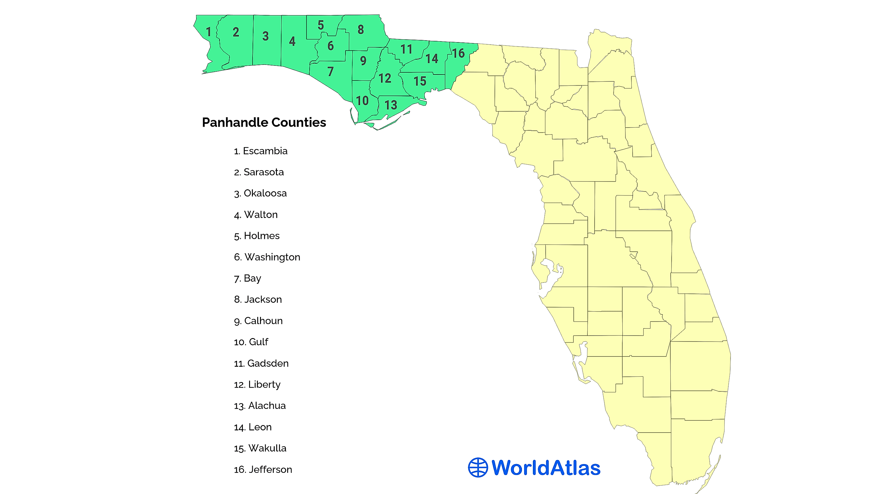
The term “panhandle” is a colloquialism used in American English to describe a narrow projection of a larger territory. While the Florida Panhandle is perhaps the most famous example, other states like Oklahoma, Texas, and West Virginia also feature these peculiar geographic extensions. The name is derived quite literally from the shape of a cooking pan; if the peninsula of Florida represents the basin of the pan, the northwestern strip serves as the long, narrow handle.
Defining the Geographic Silhouette
The Florida Panhandle encompasses roughly 200 miles in length and varies between 50 and 100 miles in width. It consists of the 18 westernmost counties of the state. Geographically, it is separated from the rest of the Florida peninsula by the Apalachicola River or, in more modern cultural contexts, the Aucilla River. The silhouette of this region became distinctive as the northern borders of Florida were finalized during the transition from colonial rule to United States territory.
Unlike the swampy, subtropical marshes of South Florida, the Panhandle shares more geological and cultural landmarks with the Deep South. Its rolling hills, pine forests, and clay soils mirror the landscapes of Alabama and Georgia, making it a distinct environmental landmark within the state.
Common Usage in American Geography
While the visual metaphor is the primary reason for the name, the term “panhandle” did not enter common parlance until the mid-19th century. During the era of westward expansion, as state lines were being surveyed with geometric precision, these “strips” of land became prominent features on national maps. For Florida, the name stuck because it perfectly captured the logistical reality of the state: the distance from the westernmost city, Pensacola, to the southern tip of the state is greater than the distance from Pensacola to Chicago. The “handle” was not just a shape, but a vast distance that required its own regional identity.
The Historical Borders: From West Florida to Statehood
The creation of the Florida Panhandle as a political entity is the result of centuries of colonial maneuvering between Spain, Great Britain, and the United States. The “handle” exists today because of how the British Empire chose to divide its newly acquired territories in the 1760s.
The British Influence and the Divided Territory
In 1763, following the Seven Years’ War, Spain ceded Florida to Great Britain. Finding the territory too large and unwieldy to govern from a single point, the British divided it into two separate colonies: East Florida, with its capital at St. Augustine, and West Florida, with its capital at Pensacola.
West Florida originally extended all the way to the Mississippi River, encompassing parts of modern-day Louisiana, Mississippi, and Alabama. This division is the historical root of the Panhandle. When Spain regained the Floridas after the American Revolutionary War, they maintained this two-province system. It wasn’t until the United States acquired the land that the borders began to shrink into the familiar handle shape we see today.
The Adams-Onís Treaty and the Final Boundaries
The modern northern border of the Panhandle was solidified by the Adams-Onís Treaty of 1819. As the United States negotiated with Spain, the northern boundary was set at the 31st parallel north. The western boundary was eventually established at the Perdido River, separating Florida from the Alabama Territory.
These geopolitical decisions left Florida with a long, narrow western reach that remained largely isolated from the burgeoning developments in Atlantic Florida. Because Tallahassee was eventually chosen as the capital in 1824—primarily because it sat at the midpoint between the two old colonial capitals of Pensacola and St. Augustine—the Panhandle became the political heart of the state, despite its “handle” status.
Iconic Natural Landmarks of the Region
The Florida Panhandle is home to some of the most unique natural landmarks in North America. Its environmental profile is vastly different from the coral-based geography of the Florida Keys or the limestone base of the central peninsula.
The Emerald Coast and the Appalachian Quartz Sand
One of the most striking landmarks in the region is the Emerald Coast, a stretch of shoreline that includes Destin, Fort Walton Beach, and Panama City Beach. The defining feature of this landmark is the sand, which is famously white and powdery.
Geologically, this sand is an extension of the Appalachian Mountains. Millions of years ago, as the mountains eroded, quartz particles were washed down through the Apalachicola River and into the Gulf of Mexico. The currents then deposited this 99% pure quartz sand along the Panhandle’s shores. Because the sand is quartz, it doesn’t absorb heat like typical shell-based sand, allowing it to remain cool to the touch even under the intense Florida sun. The interaction of the sun with the clear, shallow water over this white sand creates the brilliant green hue that gives the Emerald Coast its name.
Florida Caverns State Park and Inland Geological Wonders
While the coast is the primary draw, the inland Panhandle contains geological landmarks that are rare in the rest of the state. Florida Caverns State Park, located near Marianna, is the only state park in Florida where visitors can explore air-filled caves. These limestone caverns feature stalactites, stalagmites, and flowstones that have formed over thousands of years.
This landmark highlights the karst topography of the Panhandle—a landscape formed from the dissolution of soluble rocks. While much of Florida sits on a limestone plateau, the elevation changes in the Panhandle (reaching the highest point in the state at Britton Hill) allow for these unique subterranean formations that are absent in the flatter southern regions.
Historic Architecture and Military Landmarks
The Florida Panhandle serves as a repository for some of the oldest architectural landmarks in the United States. Its strategic location on the Gulf of Mexico made it a focal point for military defense throughout the 19th and 20th centuries.
Fort Pickens and the Defense of the Gulf
Located on Santa Rosa Island near Pensacola, Fort Pickens is a massive pentagonal brick fortification completed in 1834. It was designed to defend Pensacola Bay and its vital navy yard. As a historical landmark, it is significant for being one of the few Southern forts to remain in Union hands throughout the entirety of the American Civil War.
The fort’s architecture, characterized by its low-profile walls and intricate arches, represents the “Third System” of United States coastal fortifications. Today, it stands as a centerpiece of the Gulf Islands National Seashore, offering a tangible link to the Panhandle’s maritime military history.
The National Naval Aviation Museum
In Pensacola, the National Naval Aviation Museum serves as a modern landmark of global significance. It is one of the most visited museums in Florida and houses over 150 restored aircraft representing the Navy, Marine Corps, and Coast Guard.
The museum and the adjacent Naval Air Station Pensacola are the home base for the Blue Angels, the United States Navy flight demonstration squadron. This landmark cements the Panhandle’s reputation as the “Cradle of Naval Aviation,” a title the region has held since the early 20th century when the first permanent naval air station was established here.
The Florida State Capitol and Tallahassee’s Institutional Heritage
Moving east within the Panhandle, the Florida State Capitol in Tallahassee represents the pinnacle of the region’s political landmarks. The site features the Old Capitol, a 19th-century building restored to its 1902 appearance, with its iconic candy-striped awnings and stained-glass dome. Towering behind it is the New Capitol building, a 22-story skyscraper that serves as the executive and legislative center of the state.
Tallahassee itself is a landmark of Southern heritage, characterized by its “canopy roads”—ancient oaks draped in Spanish moss that form natural tunnels over the streets. This area provides a stark architectural and cultural contrast to the neon-lit skylines of Miami or the theme-park architecture of Orlando.
Coastal Beacons and Protected Landscapes
The southern edge of the Panhandle handle is dotted with landmarks designed to guide travelers and preserve the natural state of the Gulf of Mexico coastline.
St. Marks Lighthouse and Gulf Navigation
One of the most photogenic landmarks in the Panhandle is the St. Marks Lighthouse. Located within the St. Marks National Wildlife Refuge, this lighthouse is the second oldest light station in Florida. Its current tower, completed in 1842, has weathered numerous hurricanes, the Civil War, and the slow encroachment of the sea.
The lighthouse serves as a gateway to the Apachee Bay and stands as a testament to the early 19th-century efforts to make the treacherous Gulf waters navigable for trade. The surrounding refuge is a landmark of conservation, providing a critical habitat for migratory birds and the American alligator.

Gulf Islands National Seashore
Perhaps the most expansive landmark in the region is the Gulf Islands National Seashore. Stretching from Mississippi into the Panhandle, this federally protected area includes barrier islands like Santa Rosa Island and Perdido Key.
These islands are dynamic landmarks, constantly reshaped by the wind and waves of the Gulf of Mexico. They offer a glimpse into what the Florida coast looked like before the era of high-rise development. The dunes here, some of the highest in the state, are stabilized by sea oats and provide a stark, beautiful contrast to the emerald waters.
In conclusion, the Florida Panhandle is called so for its unmistakable shape, but its identity is defined by much more than a cartographic quirk. From the quartz-white sands of the Emerald Coast to the historic walls of Fort Pickens and the legislative halls of Tallahassee, the Panhandle remains a collection of the most significant and diverse landmarks in the Southwestern United States. Its name serves as a simple shorthand for a region rich in history, geology, and cultural distinctiveness.
LifeOutOfTheBox is a participant in the Amazon Services LLC Associates Program, an affiliate advertising program designed to provide a means for sites to earn advertising fees by advertising and linking to Amazon.com. Amazon, the Amazon logo, AmazonSupply, and the AmazonSupply logo are trademarks of Amazon.com, Inc. or its affiliates. As an Amazon Associate we earn affiliate commissions from qualifying purchases.