
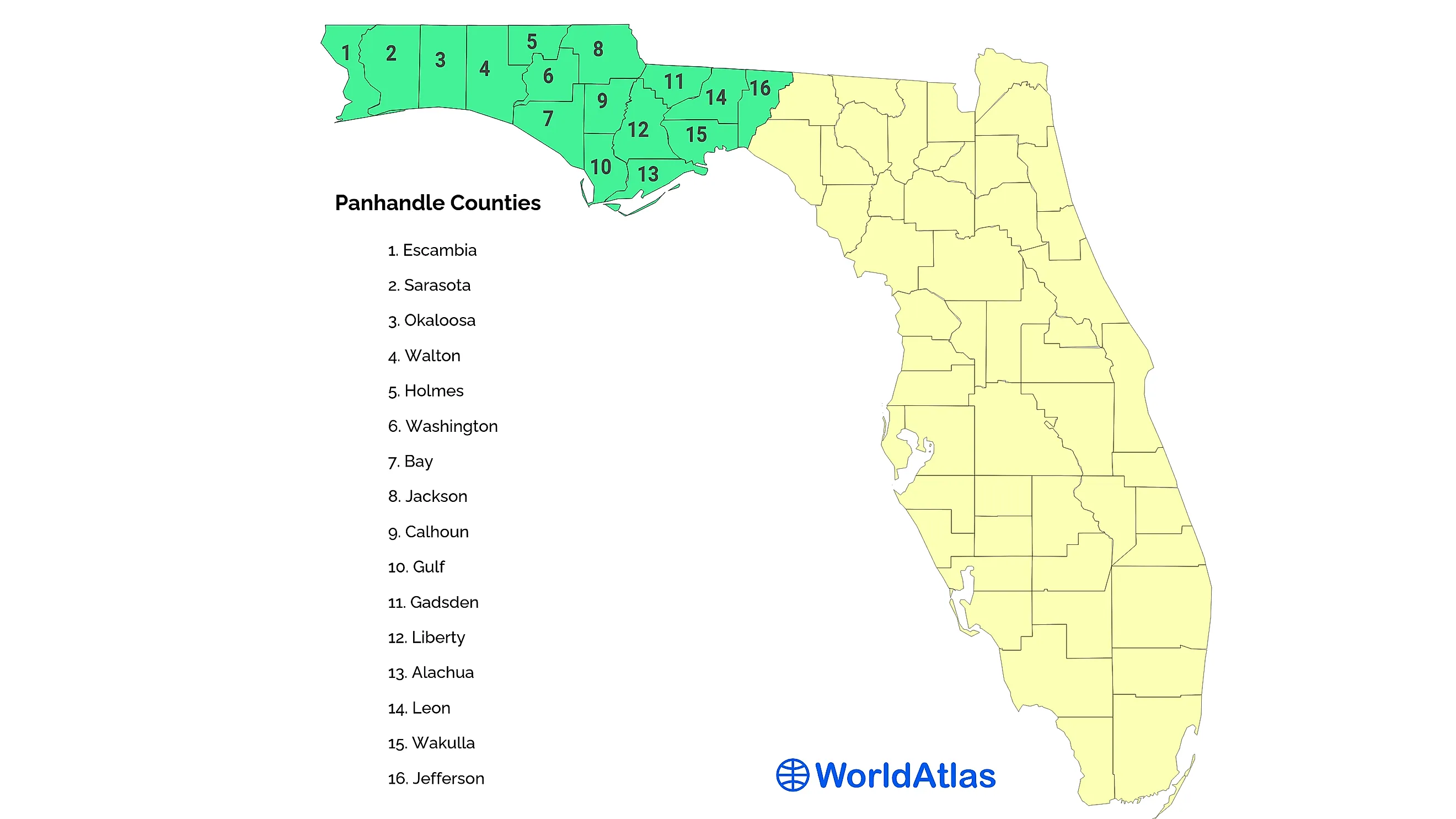
The geographical silhouette of the United States is defined by several distinctive features, but few are as recognizable as the Florida peninsula. However, extending westward from the northern neck of the state is a narrow strip of land that defies the vertical orientation of the rest of the region. This 200-mile stretch, bordered by Alabama to the north and west, Georgia to the north, and the Gulf of Mexico to the south, is colloquially known as the Panhandle. The name is a descriptive term based on cartographic appearance; much like the handle of a cooking pan, this region extends away from the main “body” of the state. While the name itself is a matter of simple visual analogy, the history, geology, and cultural landmarks of this region are far more complex, rooted in colonial disputes and a unique environmental tapestry.

The Geographical and Historical Origins of the Panhandle
To understand why the Panhandle exists as a distinct entity, one must look at the early colonial history of North America. During the 18th century, the territory was divided into two distinct British colonies: East Florida and West Florida. The capital of East Florida was St. Augustine, while the capital of West Florida was Pensacola. The Apalachicola River served as the primary boundary between the two. At its height, West Florida extended all the way to the Mississippi River, encompassing parts of modern-day Louisiana, Mississippi, and Alabama.
The Adams-Onis Treaty and Border Disputes
The modern shape of the Panhandle began to take form following the Adams-Onis Treaty of 1819, in which Spain ceded all of Florida to the United States. When Florida was being organized into a state, there was significant debate regarding its western borders. Residents of West Florida often felt more culturally and economically aligned with Mobile and the Deep South than with the burgeoning settlements in the Florida Keys or the Atlantic Coast.
There were several attempts throughout the 19th century to annex the Panhandle to Alabama. The reasoning was logistical; the capital, Tallahassee, was established as a compromise location between Pensacola and St. Augustine, but the vast distances made governance difficult. However, the annexation never gained enough political momentum, and the “handle” remained attached to the Sunshine State.
The Geological Significance of the Quartz Sands
One of the most striking landmarks of the Panhandle is its coastline, often referred to as the Emerald Coast. Unlike the darker, shell-heavy sands of the Atlantic Ocean side, the beaches here—such as Destin and Fort Walton Beach—consist of nearly pure white quartz. This sand is a geological landmark in its own right, having traveled thousands of years ago from the Appalachian Mountains. Carried by the Apalachicola River and ground into fine crystals, this sand gives the water its signature turquoise clarity, a defining characteristic of the Gulf of Mexico shoreline.
Iconic Natural and Maritime Landmarks
The Panhandle is home to some of the most ecologically diverse landmarks in the South. Because it is situated at the crossroads of the temperate north and the subtropical south, it features flora and fauna that cannot be found elsewhere in the state.
Gulf Islands National Seashore
Perhaps the most significant natural landmark in the region is the Gulf Islands National Seashore. Stretching from Cat Island in Mississippi to the eastern end of Santa Rosa Island in Florida, this protected area preserves the pristine beauty of the barrier islands. Within this seashore lies Fort Pickens, a massive pentagonal brick fortress completed in 1834. As a historical landmark, Fort Pickens is notable for being one of the few Union forts in the South that was never captured by the Confederacy during the Civil War.
The Forgotten Coast and Apalachicola
While the western Panhandle is known for its high-rise resorts, the eastern portion, known as the Forgotten Coast, remains a landmark of old-world Florida. Apalachicola serves as the cultural heart of this sub-region. Historically, it was the third-largest port on the Gulf of Mexico. Today, it is a landmark for sustainable maritime industry, famous for the Apalachicola Bay oysters. Nearby, St. George Island and the Cape St. George Lighthouse offer a glimpse into the maritime history that once dominated these shores.
St. Andrews State Park and Choctawhatchee Bay
In Panama City Beach, St. Andrews State Park stands as a testament to the region’s diverse ecosystems. It provides a rare look at coastal dunes, salt marshes, and pine flatwoods in a single location. Further west, Choctawhatchee Bay acts as a massive inland landmark, separating the mainland from the narrow strip of beach communities. This bay is essential for the local biodiversity, serving as a nursery for various marine species and a landmark for recreational fishing.
Architectural Landmarks and the Rise of New Urbanism
While the Panhandle’s history is rooted in military forts and fishing villages, its modern architectural landscape has gained international acclaim. The region is the birthplace of New Urbanism, a design movement that emphasizes walkable neighborhoods and traditional aesthetics.
Seaside and the 30A Corridor
The town of Seaside, located along County Road 30A, is a global architectural landmark. Founded in the 1980s, it was the first town designed according to the principles of New Urbanism. Its pastel-colored houses, white picket fences, and central town square served as the filming location for the movie The Truman Show. The success of Seaside paved the way for other architectural landmarks like Rosemary Beach, known for its Dutch West Indies style, and Alys Beach, famous for its stark white masonry inspired by Bermuda and Antigua.
The Florida State Capitol
Moving inland to Tallahassee, the Panhandle hosts the Florida State Capitol. This landmark is unique because it consists of two distinct structures: the Historic Capitol, a neoclassical building with a stunning stained-glass dome, and the modern 22-story tower. This juxtaposition of the old and the new mirrors the Panhandle’s own identity—a region that respects its deep historical roots while continuing to grow as a modern political and cultural hub.
Pensacola Naval Air Station and the National Naval Aviation Museum
Pensacola is often called the “Cradle of Naval Aviation.” The Pensacola Naval Air Station is a landmark of military significance, serving as the training ground for all naval aviators. Located on the base is the National Naval Aviation Museum, one of the largest aviation museums in the world. It houses over 150 restored aircraft and is the home base for the Blue Angels, the world-renowned flight demonstration squadron.
Inland Natural Landmarks and the Red Hills Region
While the beaches garner the most attention, the interior of the Panhandle contains landmarks that feel worlds away from the coast. The northern sections of the Panhandle are part of the Red Hills Region, characterized by rolling hills and red clay soil that is more typical of Georgia than the rest of Florida.
Edward Ball Wakulla Springs State Park
Located south of Tallahassee, Edward Ball Wakulla Springs State Park is home to one of the largest and deepest freshwater springs in the world. As a natural landmark, it has provided a backdrop for early Hollywood films, including Tarzan and Creature from the Black Lagoon. The Wakulla Springs Lodge, built in 1937, remains a landmark of Mediterranean Revival architecture, featuring hand-painted ceiling beams and period-accurate furnishings.
Florida Caverns State Park
In Marianna, the Florida Caverns State Park is the only state park in Florida that offers public tours of air-filled caves. These limestone caverns are a geological landmark, filled with stalactites, stalagmites, and flowstones that have formed over millennia. It is a stark reminder that the Panhandle’s beauty is not just found on its surface but also deep beneath its karst topography.

Eglin Air Force Base
Spanning over 460,000 acres, Eglin Air Force Base is a massive landmark of land management and military power. Much of its territory remains undeveloped, acting as a massive preserve for the longleaf pine ecosystem. This environment is crucial for the survival of the Red-cockaded Woodpecker, making the base a landmark for conservationists as much as for the military.
The Panhandle of Florida is more than just a geographical handle on a map. It is a collection of historic forts, world-class architectural experiments, and pristine natural landscapes. From the white sands of Navarre Beach to the historic streets of DeFuniak Springs, which boasts one of the world’s only naturally round spring-fed lakes, the region stands as a unique testament to the diverse heritage of the American South. Its name may have originated from a simple observation of a map, but the landmarks within the Panhandle tell a story of a region that is foundational to the identity of the United States.
LifeOutOfTheBox is a participant in the Amazon Services LLC Associates Program, an affiliate advertising program designed to provide a means for sites to earn advertising fees by advertising and linking to Amazon.com. Amazon, the Amazon logo, AmazonSupply, and the AmazonSupply logo are trademarks of Amazon.com, Inc. or its affiliates. As an Amazon Associate we earn affiliate commissions from qualifying purchases.