
California, a state synonymous with sun-drenched beaches, Hollywood glamour, and technological innovation, also carries a persistent reputation for seismic activity. The Golden State is part of the Pacific Ring of Fire, a horseshoe-shaped zone of intense volcanic and seismic activity that encircles the Pacific Ocean. This geological reality means that earthquakes are not a matter of if but when. Understanding the potential for seismic events is crucial for residents and visitors alike, influencing everything from urban planning and building codes to travel insurance and personal preparedness.
The Science Behind California’s Tremors
California’s seismic landscape is dominated by the San Andreas Fault, a colossal tectonic boundary stretching over 800 miles from northern California to the Salton Sea. This fault marks the boundary between the Pacific Plate and the North American Plate. These colossal plates are constantly, albeit imperceptibly, moving against each other. The friction generated by this movement causes stress to build up. When this accumulated stress exceeds the strength of the rocks, they rupture, releasing energy in the form of seismic waves that we experience as an earthquake.

Types of Faults and Their Implications
While the San Andreas Fault is the most famous, it’s far from the only fault line in California. The state is crisscrossed by hundreds of smaller faults, collectively known as the California Fault System. These faults can be classified into different types based on the direction of movement:
- Strike-Slip Faults: The most common type in California, where blocks of crust slide horizontally past each other. The San Andreas Fault is a prime example.
- Thrust Faults: Where one block of crust is pushed up and over another. These are often associated with mountain building.
- Normal Faults: Where one block of crust drops down relative to another, typically occurring in areas where the crust is being stretched.
The specific type and location of a fault significantly influence the potential intensity and impact of an earthquake. For instance, a shallow earthquake on a major fault directly beneath a densely populated city like Los Angeles or San Francisco would have a far more devastating effect than a moderate earthquake on a less active fault in a rural area.
Plate Tectonics in Motion
The underlying cause of California’s earthquake activity is the dynamic interaction of the Pacific Plate and the North American Plate. The Pacific Plate is moving northwestward relative to the North American Plate at an average rate of about 2 inches per year. This seemingly slow movement accumulates immense strain over time. The San Andreas Fault is the primary transform boundary accommodating this motion, but the deformation extends across a broad zone, engaging numerous smaller faults.
Predicting the Unpredictable: The Challenge of Earthquake Forecasting
The question “When is the next California earthquake?” is one that seismologists grapple with daily. While predicting the exact time, location, and magnitude of an earthquake remains an elusive goal, scientists employ sophisticated methods to forecast the probability of future seismic events.
Probabilistic Seismic Hazard Assessment
The U.S. Geological Survey (USGS) and other research institutions regularly update seismic hazard maps. These maps are not forecasts in the traditional sense of predicting a specific event. Instead, they provide a statistical assessment of the likelihood of experiencing a certain level of ground shaking in a given area over a defined period, typically 30 years. These assessments are based on:
- Historical Seismicity: Analyzing records of past earthquakes.
- Geological Data: Mapping fault lines and understanding their slip rates.
- Geodetic Measurements: Using GPS and other technologies to measure the rate of strain accumulation on faults.
- Computer Modeling: Simulating fault behavior under various stress conditions.
The “UCERF3” (Uniform California Earthquake Rupture Forecast, Version 3) is a comprehensive model that estimates the probabilities of damaging earthquakes across California. It provides probabilities for different magnitude ranges and fault systems, offering valuable insights for risk mitigation and preparedness.
What the Forecasts Tell Us
The probabilistic forecasts consistently indicate a high likelihood of significant earthquakes occurring in California in the coming decades. For example, UCERF3 estimated that there is a 99% probability of at least one magnitude 6.7 or greater earthquake occurring in California within 30 years. For a magnitude 7.0 or greater, the probability is also very high, particularly in Southern California. The forecasts also highlight specific “end-fault” scenarios where a large section of a major fault could rupture, leading to a very strong earthquake.
The Imminent Threat: Major Faults and Their Potential
While the exact timing is unknown, certain fault systems are considered to be “overdue” for a major rupture based on historical earthquake cycles and current strain accumulation.
The Southern San Andreas Fault
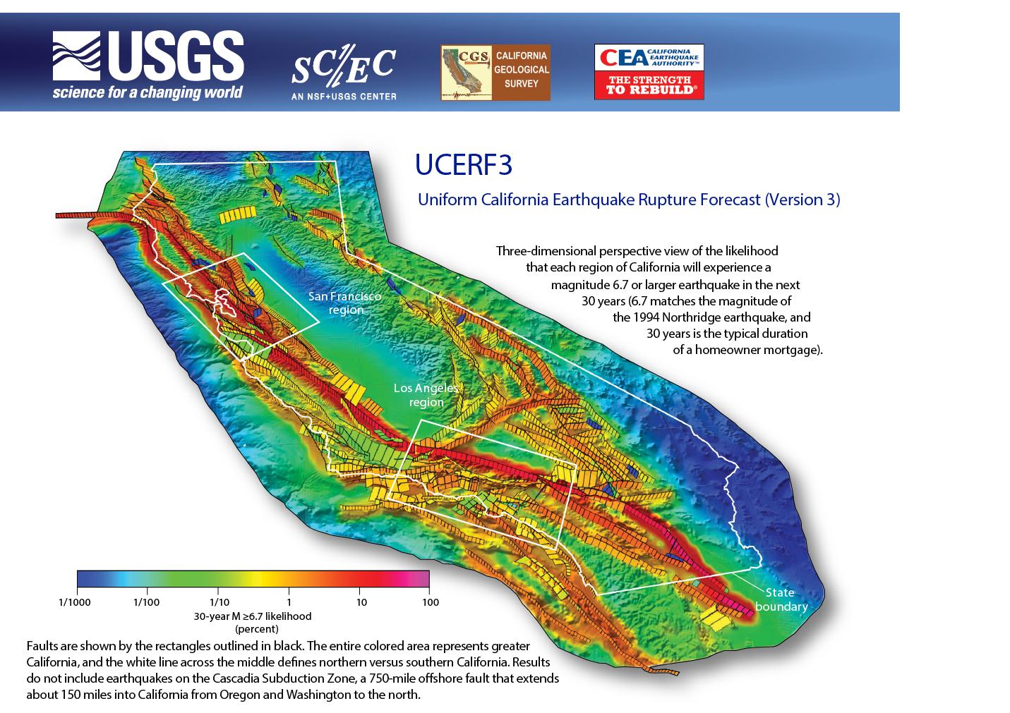
The southern section of the San Andreas Fault, particularly the segment stretching from Parkfield to the Salton Sea, is a region of significant concern. This segment has not experienced a major rupture (magnitude 7.0 or greater) since 1857 (the Fort Tejon earthquake). The accumulated strain in this area is substantial, and a rupture here could produce a powerful earthquake with widespread effects across Southern California, impacting cities from Los Angeles to Palm Springs.
The Hayward Fault
In the San Francisco Bay Area, the Hayward Fault is considered one of the most dangerous fault lines in the United States. It runs directly through densely populated urban areas, including cities like Oakland and Berkeley. Geologists estimate a significant probability of a magnitude 6.7 or greater earthquake on the Hayward Fault within the next 30 years. This fault is characterized by its creep, where small, slow movements occur without significant shaking, but also the potential for larger, more damaging ruptures.
The Puente Hills Blind Thrust Fault
Beneath the densely populated areas of Los Angeles County lies a “blind thrust fault” known as the Puente Hills Blind Thrust Fault. Blind faults are not visible at the surface, making them harder to detect and monitor. However, geological evidence suggests this fault has the potential to generate significant earthquakes, including one of magnitude 6.7 or greater, which could have catastrophic consequences for the greater Los Angeles metropolitan area.
Preparing for the Inevitable: Travel and Accommodation Considerations
For travelers planning a trip to the Golden State, understanding the seismic risk is part of responsible travel planning. While the chances of experiencing a major earthquake during a short visit are statistically low, preparedness is always wise.
Choosing Your Destination Wisely
Most of California is seismically active to varying degrees. However, some regions might experience less intense shaking during a major event compared to those situated directly on or very near major fault lines. Destinations further inland, away from the immediate coast and major fault zones like the San Andreas Fault or the Hayward Fault, might experience less severe ground motion. Nonetheless, even distant earthquakes can cause considerable shaking. The key is not to avoid California but to be aware and prepared wherever you go.
Accommodation Safety and Features
When booking accommodation in California, consider the following:
- Building Codes: Modern hotels and resorts in California are subject to stringent earthquake-resistant building codes. Newer constructions are generally safer than older, unreinforced structures. Look for hotels built after the major seismic building code updates implemented following the 1971 San Fernando earthquake and the 1994 Northridge earthquake.
- Location within the Hotel: In a seismic event, staying on a lower floor might offer a slight advantage in terms of evacuation time. However, the primary safety concern is the structural integrity of the building itself.
- Emergency Information: Familiarize yourself with the hotel’s emergency procedures. Most hotels will have information available regarding evacuation routes and assembly points. Pay attention to any safety briefings or information provided by staff.
- Securing Furnishings: In your hotel room, especially if you are staying for an extended period, consider securing tall or heavy furniture to prevent it from toppling during a tremor.
Travel Insurance and Emergency Preparedness Kits
- Travel Insurance: While not always covering earthquake damage directly, comprehensive travel insurance can provide peace of mind for trip cancellations or interruptions due to natural disasters. Review policy details carefully.
- Personal Preparedness Kit: Even for short stays, it’s prudent to have a small emergency kit. This could include a flashlight, extra batteries, a portable phone charger, and a few days’ supply of non-perishable food and water. Many hotels provide basic emergency kits.
Beyond the Tremor: Long-Term Planning and Awareness
The prospect of earthquakes in California is a constant backdrop to life in the state. For residents, this translates into ongoing efforts in preparedness, from individual household kits to community-wide disaster response plans. For visitors, it’s an opportunity to engage with a region that has learned to coexist with and respect the powerful forces of nature.
Understanding Seismic Retrofitting
Many older buildings in California, including historic landmarks and older residential buildings, have undergone seismic retrofitting to improve their resistance to earthquake damage. When visiting such structures, understand that efforts have likely been made to enhance their safety.

Community Preparedness Initiatives
Cities and counties across California actively promote earthquake preparedness. Programs like the Great California ShakeOut encourage individuals, families, and organizations to practice earthquake drills, reinforcing the importance of “Drop, Cover, and Hold On.” Being aware of these local initiatives can provide a deeper understanding of the state’s proactive approach to seismic risk.
Ultimately, the question of “when” the next California earthquake will strike remains unanswered by precise timing. However, by understanding the science, the probabilities, and the preparedness measures in place, both residents and visitors can approach their time in the Golden State with informed awareness and a sense of security. The geological dynamism that shapes California also contributes to its unique beauty and vibrant culture, making it a destination worth exploring with respect for its powerful natural environment.
LifeOutOfTheBox is a participant in the Amazon Services LLC Associates Program, an affiliate advertising program designed to provide a means for sites to earn advertising fees by advertising and linking to Amazon.com. Amazon, the Amazon logo, AmazonSupply, and the AmazonSupply logo are trademarks of Amazon.com, Inc. or its affiliates. As an Amazon Associate we earn affiliate commissions from qualifying purchases.