
Embarking on a journey between two of California’s most iconic cities, Los Angeles and San Francisco, is more than just traversing a distance; it’s an quintessential United States travel experience. Whether you’re chasing the sun-drenched beaches of Southern California or the fog-kissed hills of the Bay Area, understanding the geography, transportation options, and scenic routes is paramount to planning an unforgettable adventure. This guide delves into the various facets of this popular north-south migration, offering insights for every type of traveler looking to bridge the gap between these vibrant urban centers. From efficient expressways to breathtaking coastal drives, the journey itself can become the highlight of your trip.
The Iconic California Journey: Distance and Routes Unveiled
The physical separation between Los Angeles and San Francisco is significant, yet easily conquerable with proper planning. The choice of route will largely dictate both the travel time and the experience you’ll have along the way.
Unpacking the Direct Distance
At its most direct, the driving distance between Los Angeles and San Francisco is approximately 380 to 400 miles (about 610-645 kilometers). This measurement typically refers to the fastest, most straightforward routes, which primarily utilize major interstates. While seemingly a long haul, it’s a distance that can be covered within a single day for determined drivers, though stopping for breaks is highly recommended for safety and enjoyment. For travelers opting for air travel, the flight distance is considerably shorter, though the overall travel time still includes transit to and from airports.
The Major Thoroughfares: I-5 vs. Highway 1
When planning your trip, two primary driving routes dominate the conversation, each offering a distinct experience:
- Interstate 5 (I-5): The Efficient Corridor: This is the most direct and fastest driving route, generally taking between 5.5 to 7 hours without significant traffic or extended stops. I-5 cuts straight through California’s Central Valley, characterized by vast agricultural landscapes. While it’s efficient, it’s often criticized for its lack of scenic appeal compared to its coastal counterpart.
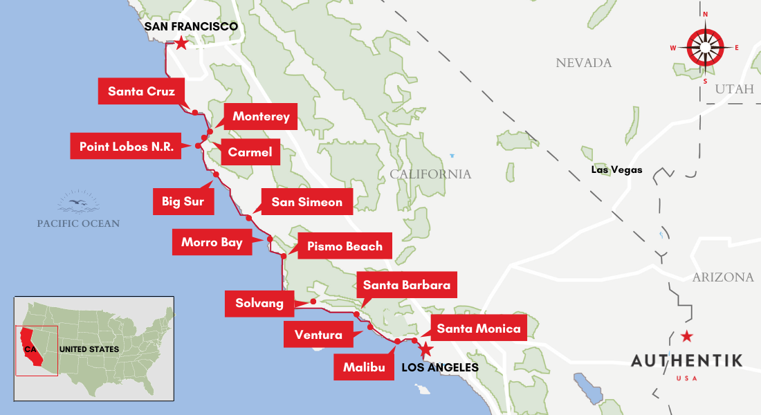
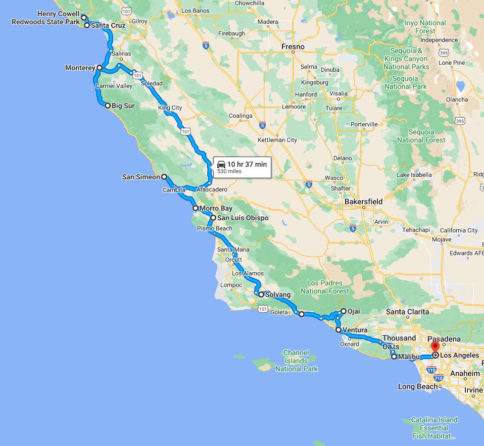
- Highway 1 (Pacific Coast Highway – PCH): The Scenic Epic: For those with more time and a desire for unparalleled beauty, Highway 1 offers an unforgettable experience. Hugging the rugged California coastline, this route stretches over 450 to 500 miles, with driving times easily exceeding 9-10 hours of pure driving, often extending to multiple days due to the numerous scenic pull-offs, charming towns, and winding roads. It’s not just a drive; it’s a destination in itself.
Strategic Planning for Your Departure
Your starting point within Los Angeles and your final destination in San Francisco can influence the precise mileage and travel time. Both cities are sprawling, and navigating urban traffic, particularly during peak hours, can add significant delays. Factor in extra time for navigating city streets at either end of your journey, especially if you’re traveling during rush hour or on a holiday weekend. Utilizing real-time traffic apps is crucial for making informed decisions on the day of travel.
Navigating the Golden State: Diverse Transportation Options
The journey between Los Angeles and San Francisco can be undertaken in various ways, each with its own advantages regarding cost, speed, comfort, and scenic value.
The Quintessential California Road Trip: Driving
Driving offers the ultimate flexibility, allowing travelers to stop whenever and wherever they please. It’s ideal for those who wish to explore beyond the main cities, discover small towns, or simply enjoy the freedom of the open road.
- Pros: Flexibility, control over itinerary, ability to carry more luggage, ideal for group travel.
- Cons: Can be tiring, susceptible to traffic delays, parking challenges in urban areas, fuel costs.
- Considerations: Vehicle maintenance, rental car costs (if applicable), toll roads (minimal on primary routes but possible), and the need for navigation tools.
Speed and Convenience: Air Travel
For travelers prioritizing speed, flying is undoubtedly the quickest option. Numerous airlines offer frequent flights between Los Angeles International Airport (LAX) and San Francisco International Airport (SFO), as well as smaller regional airports like Hollywood Burbank (BUR) or Long Beach (LGB) to Oakland (OAK) or San Jose (SJC).
- Pros: Short travel time (approx. 1 hour 15 minutes in the air), ideal for business travelers or those with limited time.
- Cons: Total travel time (including check-in, security, and airport transfers) can often rival driving for shorter distances, less scenic, luggage restrictions, often requires additional transportation to and from airports.
Scenic and Serene: Train Journeys
Amtrak provides a more relaxed and scenic alternative to driving or flying. The Pacific Surfliner connects Los Angeles as far north as San Luis Obispo, requiring a bus connection for the remainder of the journey to San Francisco. A longer, more direct option is the Coast Starlight route, which runs all the way from Los Angeles to Oakland (with a connecting bus to San Francisco).
- Pros: Comfortable, scenic (especially portions of the coastal route), no traffic worries, ability to work or relax.
- Cons: Longer travel times (often 9-12 hours including connections), less frequent departures than flights.
Budget-Friendly and Accessible: Bus Services
For budget-conscious travelers, intercity bus services like Greyhound or FlixBus offer an economical way to travel between the two cities.
- Pros: Affordable fares, multiple daily departures, convenient drop-off/pick-up points within city centers.
- Cons: Longest travel times (6-9 hours or more, depending on stops), less comfortable than train or car, less flexibility.
The Efficient Expressway: Mastering Interstate 5
For travelers prioritizing speed and efficiency, Interstate 5 is the undisputed champion. This route minimizes curves and elevation changes, providing a relatively flat and direct path through the heart of California.
The Straight Shot: What to Expect
Driving on I-5 is characterized by multi-lane highways and consistent speed limits, typically 65-70 mph (105-113 km/h). The scenery primarily consists of vast agricultural fields, stretching for miles, punctuated by occasional small towns. While not visually thrilling, it is incredibly effective at covering ground quickly. Be prepared for long stretches between major services, especially once you pass Bakersfield and head further into the Central Valley.
Essential Stops and Services Along I-5
While the I-5 might lack dramatic vistas, strategic stops are crucial for breaking up the journey.
- Gas and Rest Areas: Numerous gas stations and fast-food outlets are available at major exits, particularly around towns like Bakersfield, Coalinga, and Santa Nella. Look for roadside signs indicating services ahead.
- Harris Ranch Inn & Restaurant: A popular and well-known stop near Coalinga, offering a full-service restaurant, hotel, and gas station, famous for its steakhouse. It’s a significant landmark and a reliable place for a substantial break.
- Grapevine Pass: South of Bakersfield, you’ll encounter the Grapevine, a mountainous stretch that can experience challenging weather conditions (fog, snow in winter) and significant traffic congestion, especially when ascending or descending.
Optimizing Your I-5 Drive
To make your I-5 journey as smooth as possible:
- Travel Off-Peak: Avoid driving on Friday afternoons or Sunday evenings if possible, as these are peak times for weekend travel, particularly around Los Angeles and the Bay Area.
- Stay Hydrated and Fuelled: Carry water and snacks, and ensure your fuel tank is topped up, as service stations can be sparse in some segments.
- Audio Entertainment: Given the relatively monotonous scenery, a good playlist, podcast, or audiobook is highly recommended to keep drivers engaged and alert.
The Coastal Odyssey: Embracing Highway 1’s Splendor
For those who view the journey as part of the destination, Highway 1 offers an unparalleled road trip experience, weaving through some of the most spectacular coastal landscapes in the world.
A Drive Through Panoramic Vistas
Highway 1 is renowned for its dramatic cliffs, pristine beaches, and charming seaside towns. The road itself is often winding and narrow, especially through areas like Big Sur, requiring careful driving and slower speeds. This is not a route to rush; rather, it’s one to savor, with countless opportunities to pull over, take photos, and simply soak in the majestic views of the Pacific Ocean.
Must-See Stops: From Santa Barbara to Santa Cruz
The beauty of the Highway 1 journey lies in its wealth of attractions.
- Santa Barbara: Known for its Spanish colonial architecture, stunning beaches, and vibrant downtown. A perfect first stop from Los Angeles.
- Morro Bay: Home to the iconic Morro Rock, a distinctive volcanic plug rising from the ocean. Great for kayaking and wildlife viewing.
- San Simeon/Hearst Castle: Though Hearst Castle requires reservations and is a significant detour, it’s a world-famous historical landmark. The area around San Simeon is also excellent for spotting elephant seals.
- Big Sur: The undisputed highlight of Highway 1, a rugged stretch of coastline where mountains meet the sea. Expect dramatic cliffs, redwood forests, and iconic bridges like Bixby Bridge. Pull-offs are frequent, offering incredible photo opportunities.
- Carmel-by-the-Sea and Monterey: These charming towns offer art galleries, boutique shops, and the famous Monterey Bay Aquarium. Pebble Beach‘s scenic 17-Mile Drive is nearby, offering breathtaking coastal views (with a toll).
- Santa Cruz: A classic beach town with a historic boardwalk, famous for its surfing culture and relaxed vibe.
Planning for the Ultimate Coastal Experience
- Allow Ample Time: Plan for at least two days, preferably three or more, to genuinely enjoy the Highway 1 route without feeling rushed. Overnight stays in towns like Santa Barbara, Cambria, or Monterey are highly recommended.
- Check Road Conditions: Portions of Highway 1, especially through Big Sur, are prone to closures due to landslides, particularly during and after heavy rains. Always check the Caltrans website for current conditions before embarking.
- Start Early: Begin your driving day early to maximize daylight hours for sightseeing and avoid crowded viewpoints.
- Pack Layers: Coastal California weather can be unpredictable, even in summer. Layers are essential for adapting to temperature swings and coastal fog.
Preparing for Your North-South California Adventure
Regardless of the route or mode of transport chosen, a well-prepared traveler ensures a smoother and more enjoyable journey.
Choosing the Best Time to Travel
- Spring (March-May): Generally mild weather, fewer crowds than summer, and the “super bloom” phenomenon in some areas if winter rains were abundant. Highway 1 is particularly beautiful with green hills.
- Summer (June-August): Peak travel season. Expect warmer temperatures, larger crowds, and higher prices. San Francisco often experiences its famous fog, while Los Angeles is typically sunny and warm.
- Fall (September-November): Often considered the best time to visit California. Pleasant temperatures, fewer crowds, and less fog in San Francisco.
- Winter (December-February): Cooler temperatures, potential for rain (especially in Northern California), and the possibility of snow on mountain passes like the Grapevine. Can be a good time for budget travel and fewer crowds, but be mindful of road conditions on Highway 1.
Packing Essentials for a Diverse Climate
Given the diverse climates between Southern and Northern California, and the varying altitudes, packing versatile layers is key. Even in summer, evenings in San Francisco can be surprisingly chilly. Include light clothing for warmer areas, a sweater or jacket for cooler evenings, comfortable walking shoes, sunglasses, and sunscreen. Don’t forget chargers for all your devices and a camera to capture the stunning scenery.
Vehicle Considerations and Rental Tips
If driving, ensure your vehicle is in good working order, with tires, brakes, and fluid levels checked. If renting a car, consider one that offers good fuel efficiency for the long distances. Booking in advance, especially during peak season, can secure better rates and ensure availability. Familiarize yourself with the rental agreement’s mileage limits and insurance options.

Safety and Road Awareness
Always prioritize safety. Take frequent breaks when driving to combat fatigue. Adhere to speed limits and be particularly cautious on winding roads or in areas with wildlife. In case of emergency, carry a fully charged phone and emergency supplies. Be aware of your surroundings, especially when stopping in isolated areas.
The journey from Los Angeles to San Francisco is more than a simple trip; it’s an exploration of California’s vast and varied landscape. Whether you opt for the efficiency of I-5 or the majestic beauty of Highway 1, thorough planning and an open mind will ensure a travel experience as memorable as the destinations themselves.
LifeOutOfTheBox is a participant in the Amazon Services LLC Associates Program, an affiliate advertising program designed to provide a means for sites to earn advertising fees by advertising and linking to Amazon.com. Amazon, the Amazon logo, AmazonSupply, and the AmazonSupply logo are trademarks of Amazon.com, Inc. or its affiliates. As an Amazon Associate we earn affiliate commissions from qualifying purchases.