
The question “How far is Oakland to San Francisco?” seems straightforward, yet its answer unveils the rich tapestry of transit, geography, and urban interconnectedness that defines the Bay Area. These two iconic cities, anchors of California‘s vibrant northern coast, are separated by the shimmering expanse of the San Francisco Bay, a natural barrier that has shaped their development and dictated the means by which millions traverse between them daily. While geographically close, the actual travel distance and time can vary dramatically depending on the chosen mode of transport, traffic conditions, and the specific departure and arrival points within each metropolitan hub. Understanding this dynamic is crucial for anyone planning to navigate this bustling region, whether for daily commutes, business trips, or leisurely explorations of the diverse attractions each city offers. This guide delves into the various distances and transportation methods, offering insights to help you choose the most efficient, enjoyable, or scenic route across the bay.
The Geographic Proximity: More Than Just Miles
At its core, the distance between Oakland and San Francisco is measured not just in miles, but in the ingenuity of engineering and the flow of daily life that connects two distinct urban landscapes. The natural separation by the San Francisco Bay makes this journey unique, transforming a relatively short geographical gap into a multifaceted transit experience.
The Straight Line vs. Real-World Distance
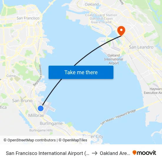
“As the crow flies,” the shortest distance across the San Francisco Bay from downtown Oakland to downtown San Francisco is approximately 8 to 10 miles (13 to 16 kilometers). This direct measurement, however, is largely theoretical for human travel, as it involves crossing open water. The reality of traversing this distance introduces various pathways, each with its own specific length and character. The majestic Bay Bridge stands as the primary vehicular artery, an engineering marvel that physically connects the East Bay with the Peninsula, fundamentally altering the straight-line perception of distance into a tangible roadway. This bridge, along with underwater tunnels for public transit, defines the practical routes available.
Key Distances and Routes
When considering real-world travel, distances are typically measured along established routes. For motorists, the journey across the Bay Bridge is the most common path.
- Driving via the Bay Bridge: The total driving distance from a central point in Oakland (e.g., Jack London Square) to downtown San Francisco (e.g., near the Ferry Building) is roughly 10-15 miles (16-24 kilometers). This distance can fluctuate slightly depending on the exact starting and ending points within each city. The multi-lane bridge structure itself is about 8.4 miles (13.5 kilometers) long.
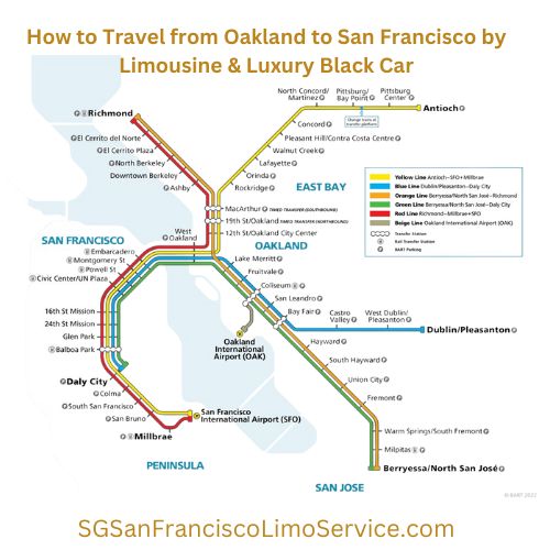
- Public Transit (BART): For those opting for the Bay Area Rapid Transit (BART) system, the journey takes place mostly underground through the Transbay Tube. While not a “distance” in the driving sense, the ride covers a comparable stretch, connecting stations like Oakland Coliseum or 12th Street Oakland City Center to San Francisco hubs like Embarcadero or Powell Street. The travel time is a more relevant metric here, often ranging from 15 to 25 minutes between central stations.
- Ferry Service: The San Francisco Bay Ferry offers another scenic option. From Jack London Square in Oakland to the Ferry Building in San Francisco, the ferry route covers a water distance of approximately 10 miles (16 kilometers), providing unique perspectives of the bay and its landmarks.
These various routes highlight that while the core distance is relatively short, the method of traversal profoundly impacts the experience and logistics of getting from one city to the other.
Navigating the Bay: Your Travel Options
The diversity of travel options between Oakland and San Francisco is a testament to the region’s commitment to connectivity and efficiency. Each mode of transport offers a unique set of advantages, catering to different preferences for speed, cost, scenery, and convenience.
Driving Across the Bay
Driving remains a popular choice for many, offering direct access and flexibility. The Bay Bridge is the essential link, a double-decked span that carries hundreds of thousands of vehicles daily.
- Tolls and Traffic: Be aware that a toll is charged when entering San Francisco from Oakland via the Bay Bridge. Tolls vary by time of day and day of the week, with higher rates during peak hours. Traffic congestion is a significant factor, especially during weekday commute times (roughly 6 AM to 10 AM and 3 PM to 7 PM) and on weekends. A journey that might take 15-20 minutes in light traffic can easily stretch to 45-60 minutes or more during peak periods.
- Parking: Finding and paying for parking in San Francisco, particularly downtown, can be challenging and expensive. Consider parking garages or ride-sharing services once you arrive.
- Car Rentals: Numerous car rental agencies operate in both cities and at Oakland International Airport (OAK) and San Francisco International Airport (SFO), offering flexibility for those exploring beyond the immediate city centers.
Public Transportation: BART and Ferries
For many, public transportation is the most efficient and stress-free way to cross the bay, circumventing traffic and parking woes.
- BART (Bay Area Rapid Transit): BART is the backbone of cross-bay public transit. Its trains run frequently, connecting major hubs in Oakland to downtown San Francisco via the Transbay Tube.
- Routes and Stations: Key Oakland stations include 12th Street Oakland City Center, 19th Street Oakland, and MacArthur. In San Francisco, trains stop at Embarcadero, Montgomery Street, Powell Street, and Civic Center/UN Plaza, among others.
- Travel Time and Cost: The actual ride between central stations is typically 15-25 minutes. Fares are distance-based and can be paid using a Clipper Card (a reloadable transit card) or a single-use paper ticket. BART is generally highly reliable, though occasional delays can occur.
- San Francisco Bay Ferry: For a more scenic and relaxed journey, the San Francisco Bay Ferry offers a delightful alternative.
- Routes: The primary route between Oakland and San Francisco departs from Jack London Square in Oakland and arrives at the iconic Ferry Building in San Francisco. There are also connections to other points like Alameda and Richmond.
- Experience: Ferries provide stunning views of the San Francisco skyline, the Bay Bridge, and sometimes even Alcatraz Island or the Golden Gate Bridge on clear days. The journey typically takes around 20-30 minutes, not including boarding and disembarking time.
- Cost: Fares are comparable to or slightly higher than BART, and can also be paid with a Clipper Card. It’s an excellent option for tourists or those who prefer a less congested commute.
Ride-Sharing and Taxis
Services like Uber, Lyft, and traditional taxis offer door-to-door convenience. The cost will vary significantly based on demand, time of day, and traffic, but typically ranges from $30-$60, excluding surge pricing during peak hours or special events. This option combines the flexibility of driving with the convenience of not having to park. Keep in mind that these services are still subject to Bay Bridge tolls and traffic delays.

Cycling and Walking (For the Adventurous)
While not a direct route across the San Francisco Bay, dedicated cyclists can combine biking with public transport. For instance, you can cycle to a BART station, take your bike on BART across the tube (with some restrictions during peak hours), and then continue cycling in San Francisco. There are also long-distance cycling routes that go around the entire bay, but this is a multi-day journey, not a typical commute. Walking across the Bay Bridge is not permitted. However, walking sections of the Bay Bridge Trail on the East Span offers incredible views, though it doesn’t cross the bay into San Francisco itself.
Factors Influencing Travel Time
Beyond the sheer distance, several dynamic factors can significantly impact how long it takes to travel from Oakland to San Francisco. Understanding these variables is key to planning an efficient journey.
Traffic Congestion
The primary determinant of travel time, especially for drivers, is traffic congestion. The Bay Area is known for its dense population and bustling economy, leading to predictable and often severe traffic jams.
- Peak Hours: Weekday morning commutes (typically 6:00 AM – 10:00 AM) and evening commutes (3:00 PM – 7:00 PM) see the heaviest traffic on the Bay Bridge and surrounding freeways. A 15-minute drive can easily become an hour-long ordeal during these times.
- Weekend and Event Traffic: Weekends, particularly Friday evenings and Sunday afternoons, can also experience significant delays due to leisure travelers and events. Major sports games (e.g., at Oracle Park or the Chase Center in San Francisco, or the former Oakland Arena) or large conventions can add to the gridlock.
- Bridge Bottlenecks: The Bay Bridge is a critical bottleneck. Even outside of peak hours, incidents like accidents, stalled vehicles, or construction can cause sudden and prolonged delays.
Public Transit Schedules
While BART and ferries largely avoid vehicular traffic, their schedules and operational realities also influence travel time.
- Frequency: BART trains run very frequently during peak hours (every 5-10 minutes) but less often during off-peak times, evenings, and weekends (every 15-20 minutes). Missing a train can add significant waiting time.
- Potential Delays: Although generally reliable, BART can experience delays due to mechanical issues, police activity, or track work. Real-time updates are available via their app and station announcements.
- Ferry Schedules: Ferry services have fixed schedules, which are less frequent than BART, especially on weekends and holidays. It’s crucial to check the timetable in advance to avoid long waits.
Special Events and Construction
The Bay Area is a hub for cultural, sporting, and business events. These can have a ripple effect on travel times across all modes of transport.
- Major Events: Concerts, festivals (like Outside Lands), marathons (like the San Francisco Marathon), and large conferences can drastically increase traffic and public transit ridership, leading to delays and crowded conditions.
- Construction: Infrastructure projects, including maintenance on the Bay Bridge or BART lines, can sometimes necessitate lane closures or service adjustments, impacting travel times. Checking local news and transit authority websites for advisories is always recommended.
Choosing Your Ideal Route: Considerations for Travelers
Selecting the best way to travel between Oakland and San Francisco isn’t just about distance; it’s about matching your mode of transport to your specific needs, priorities, and travel style. Each type of traveler will find different aspects appealing.
For Business Travelers
Efficiency, predictability, and connectivity are paramount for business travelers.
- BART is often the top choice: Its consistent travel times, direct connections to downtown financial districts in San Francisco (like Montgomery Street and Embarcadero), and avoidance of traffic make it highly reliable for scheduled meetings.
- Ride-sharing/Taxis: These offer door-to-door convenience for those carrying luggage or needing to reach specific, less transit-accessible locations, particularly for early morning or late-night trips when BART frequency is reduced. However, factor in potential traffic delays.
- Consider proximity: If your destination in Oakland is near a BART station, and your San Francisco meeting is close to one as well, BART is unbeatable.
For Tourists and Sightseers
For visitors, the journey itself can be part of the experience.
- San Francisco Bay Ferry for the views: This is arguably the most picturesque way to cross the bay. The panoramic vistas of the San Francisco skyline, Alcatraz Island, and the Golden Gate Bridge (from a distance) are unforgettable. It’s also convenient for reaching attractions like Fisherman’s Wharf or Pier 39 once you arrive at the Ferry Building.
- BART for speed and reach: If time is a factor, or if you plan to visit attractions further into San Francisco (e.g., Union Square or Chinatown), BART offers a quick and easy connection to central areas, from which you can use other local transit like cable cars or buses.
- Driving for flexibility (with caveats): While it offers freedom to explore, the challenges of traffic, tolls, and expensive parking in San Francisco can quickly diminish the enjoyment for tourists. Consider driving only if you plan to visit multiple, geographically dispersed sites that are poorly served by public transport, or if you’re venturing far beyond San Francisco to other regions.
For Residents and Commuters
Daily users prioritize cost-effectiveness, reliability, and sustainability.
- BART is the workhorse: For most commuters, BART is the most practical and sustainable option, offering a balance of speed, cost, and frequency. Many residents choose housing in Oakland or other East Bay cities specifically for easier BART access.
- Ferry for a calmer start/end to the day: Some commuters opt for the ferry for a more relaxing and scenic journey, trading a bit of speed for a more pleasant experience.
- Carpooling/Vanpooling: To mitigate traffic and toll costs, many drivers participate in carpool or vanpool programs, often utilizing dedicated HOV (High Occupancy Vehicle) lanes where available, potentially shortening commute times.
In conclusion, the distance from Oakland to San Francisco is a mere handful of miles, yet the journey across the bay is a rich experience shaped by a variety of travel choices. From the subterranean speed of BART to the scenic charm of the ferry or the directness of a drive across the iconic Bay Bridge, each option provides a distinct way to connect these two vibrant cities. By considering factors like time of day, personal budget, and desired experience, you can confidently choose the ideal route to navigate this dynamic and beautiful region of the United States.
LifeOutOfTheBox is a participant in the Amazon Services LLC Associates Program, an affiliate advertising program designed to provide a means for sites to earn advertising fees by advertising and linking to Amazon.com. Amazon, the Amazon logo, AmazonSupply, and the AmazonSupply logo are trademarks of Amazon.com, Inc. or its affiliates. As an Amazon Associate we earn affiliate commissions from qualifying purchases.