
California, a land of unparalleled natural beauty and diverse landscapes, remains a top global destination for travelers seeking everything from pristine beaches to majestic mountains and vibrant urban centers. However, the state is also known for its wildfire season, which can pose unique challenges and considerations for tourism. Understanding the status of wildfires, particularly their containment levels, is crucial for visitors planning a trip to the Golden State. Rather than a deterrent, navigating California during fire season requires informed planning and a focus on safety, ensuring that tourists can still experience the best the state has to offer while remaining mindful of environmental realities.
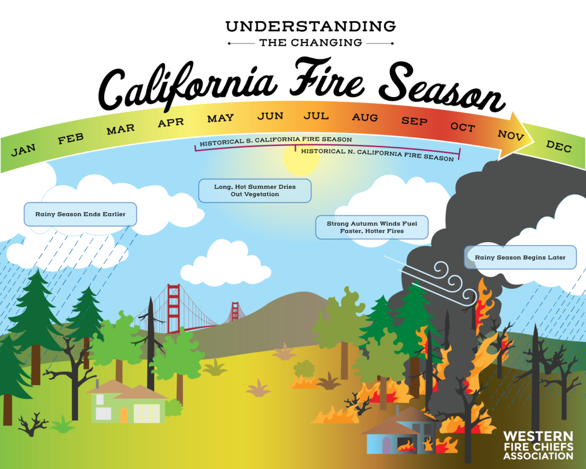
Understanding Wildfire Containment for California Tourism
For tourists, the term “containment” is perhaps the most significant indicator of a wildfire’s status, directly influencing safety, air quality, and accessibility to various attractions. It’s a measure that helps visitors assess risks and make informed decisions about their travel plans.
What “Containment” Means for Visitors
When fire agencies report a wildfire as “contained,” it means that a control line has been completed around a percentage of the fire’s perimeter, and firefighters are confident that the fire will not spread beyond that line. A fire at 0% containment is actively growing and uncontrolled, while 100% containment signifies that the fire’s spread has been completely stopped, though it may still be burning within the containment lines.
From a tourism perspective, containment levels translate directly into safety and accessibility:
- Low Containment (0-20%): Areas near such fires are highly dangerous, with active evacuations, road closures, and significant air quality issues. Tourism in adjacent regions would be severely impacted, and travel to or through these areas is strongly discouraged.
- Moderate Containment (21-79%): While the threat of spread is decreasing, significant firefighting operations are ongoing. Road closures may still be in effect, and smoke impacts can extend for many miles. Some peripheral attractions might reopen, but caution is paramount, and constant monitoring of local advisories is essential.
- High Containment (80-99%): The immediate threat has largely passed, and firefighters are focusing on extinguishing hot spots within the perimeter. Air quality typically improves, and road closures are often lifted. Affected parks and attractions might begin reopening, though fire-damaged areas will remain closed for recovery.
- 100% Containment: The fire is no longer spreading, though it might still be active inside the burned area. Most associated road closures are removed, and air quality returns to normal. Affected natural areas, however, may remain closed for rehabilitation for extended periods.
For tourists, understanding these distinctions helps to interpret news reports and official alerts, allowing for more precise itinerary adjustments rather than broad cancellations.
Key Agencies and Information Sources
Reliable, up-to-the-minute information is a tourist’s best friend during California’s fire season. Several key agencies provide critical updates:
- CAL FIRE: As California’s state fire agency, CAL FIRE provides comprehensive information on all active wildfires, including containment percentages, acreage burned, and incident specifics. Their website and social media channels are invaluable resources.
- U.S. Forest Service: For fires occurring on national forests and other federal lands, the U.S. Forest Service (USFS) is the primary reporting authority. Their incident information system (InciWeb) offers detailed maps and daily updates.
- County Sheriff’s Offices and Emergency Services: Local authorities manage evacuation orders, road closures, and community-specific alerts. Tourists should always monitor local county websites and emergency alert systems for immediate safety information.
- National Weather Service: Provides critical weather forecasts, including red flag warnings (indicating high fire danger), which are crucial for understanding potential fire behavior and spread.
- Air Quality Districts: Websites like AirNow.gov or regional air quality management districts offer real-time air quality index (AQI) data, essential for protecting respiratory health.
Tourists should consult these official sources frequently, cross-referencing information to ensure accuracy and to gain a full picture of conditions in their planned travel areas.
Impact on Popular Tourist Destinations
Wildfires are not monolithic, and their impact on tourism can vary dramatically depending on location, proximity to population centers, and the specific nature of the tourist attraction. California’s vastness means that while one region might be battling a major blaze, another could be entirely unaffected.
National Parks and Forests
California is home to some of America’s most iconic National Parks, including Yosemite National Park, Sequoia National Park, and Kings Canyon National Park. These areas, largely wild and forested, are often at the epicenter of wildfire activity.
- Closures and Reroutes: Wildfires can lead to full park closures or the closure of specific sections, trails, and campgrounds. Even if a fire is outside park boundaries, smoke can cause health hazards, leading to advisory warnings or limited access.
- Rehabilitation Efforts: Post-fire, areas may remain closed for months or even years to allow for ecological recovery, hazard tree removal, and trail restoration. Tourists should respect these closures, which are vital for safety and long-term environmental health.
- Alternative Experiences: Even if a park is partially affected, there might be unaffected areas or nearby state parks and recreation areas that offer similar natural experiences. Flexibility in itinerary is key. For example, if southern parts of Yosemite National Park are impacted, northern sections or less visited adjacent forests might still be accessible.
Coastal Regions and Urban Centers
Fortunately, California’s popular coastal destinations and major urban hubs like San Francisco, Los Angeles, and San Diego are less directly threatened by wildfires. However, they are not entirely immune to their effects.
- Air Quality: Smoke plumes can travel hundreds of miles, causing significant dips in air quality in metropolitan areas. This can impact outdoor activities and scenic views. Tourists with respiratory conditions should pay particular attention to AQI reports.
- Evacuation Impact: In some cases, fires in hills surrounding urban areas (e.g., the Santa Monica Mountains near Los Angeles) can lead to local evacuations and road closures, affecting access to specific attractions or neighborhoods.
- Indirect Effects: While the Pacific Coast Highway is generally safe, fires inland can occasionally cause closures on feeder roads or impact popular destinations like Big Sur if they spread towards the coast.

Wine Country and Agricultural Tourism
Regions like Napa Valley and Sonoma County are not only world-renowned for their vineyards but are also areas prone to wildfires.
- Direct Damage: Vineyards and wineries can suffer direct damage, leading to temporary closures for tours and tastings.
- Smoke Taint: A unique challenge for wine country is “smoke taint,” where smoke particles can affect grape quality. This often impacts future vintages rather than immediate tourist experiences but can cause concerns for local businesses.
- Resilience and Reopening: These communities are incredibly resilient. Even after significant fires, many wineries and restaurants reopen quickly, eager to welcome visitors and demonstrate their recovery. Supporting them through tourism is vital.
Navigating California During Fire Season: Tips for Tourists
Traveling to California during fire season doesn’t have to be daunting. With proper preparation and a proactive approach, visitors can still enjoy a safe and memorable trip.
Prioritizing Safety and Preparedness
- Stay Informed: Before and during your trip, continuously check official sources (CAL FIRE, U.S. Forest Service, National Weather Service, local news) for wildfire updates, air quality alerts, and road conditions.
- Have an Evacuation Plan: If you’re staying in or near a fire-prone area, know your evacuation routes and have a “go bag” ready. Sign up for local emergency alerts.
- Respect Warnings and Closures: Never ignore road closures, evacuation orders, or park advisories. These are put in place for your safety and to facilitate emergency operations.
- Be Fire Aware: If you’re camping or hiking, be extremely cautious with any potential fire sources. Check fire restrictions in place, and never throw cigarette butts out of car windows.
Flexibility and Alternative Itineraries
- Book Flexible Accommodations and Flights: Opt for hotels and airlines that offer free cancellation or changes, especially if traveling during peak fire season (typically late summer to fall).
- Plan “Plan B” Options: Have alternative destinations in mind. If Yosemite National Park is impacted, consider coastal towns, urban centers, or state parks in less fire-prone regions like those along the Pacific Ocean.
- Coastal vs. Inland: Consider prioritizing coastal destinations (San Francisco, Monterey, Santa Barbara, San Diego) during peak fire season, as they tend to be less directly affected.
Supporting Local Communities
- Dine Locally and Shop Local: When visiting communities that have been impacted by wildfires, patronizing local businesses helps them recover and thrive.
- Be Patient and Understanding: Tourism provides much-needed revenue, but communities recovering from fires may experience staff shortages or slower service. A kind and understanding attitude goes a long way.
- Support Relief Efforts: Consider donating to reputable organizations that assist wildfire victims or aid in ecological restoration.
The Long-Term Perspective: Resilience and Recovery
California’s landscapes are shaped by fire, and its communities have developed remarkable resilience. Tourists play a role not just in immediate safety but also in the long-term recovery and sustainable future of the state’s natural treasures.
Ecosystem Regeneration and Visitor Education
While devastating, wildfires are a natural part of many California ecosystems. Post-fire, new growth emerges, and the landscape transforms. Some parks and natural areas offer interpretive programs to educate visitors on the role of fire in ecology and the ongoing recovery process. Observing regeneration can be a powerful and educational aspect of a visit.

Sustainable Tourism Practices
Understanding the challenges of wildfires also encourages more sustainable and responsible tourism. This includes:
- Minimizing Your Impact: Adhering to Leave No Trace principles, especially in natural areas, helps reduce human-caused fires.
- Supporting Conservation: Choosing tour operators and accommodations that prioritize environmental sustainability and contribute to conservation efforts.
- Advocacy: Engaging with organizations that work on wildfire prevention, forest health, and climate change resilience can help protect California’s beauty for future generations of tourists.
By staying informed, planning wisely, and acting responsibly, travelers can continue to explore the magnificent and diverse landscapes of California, even as they navigate the realities of its fire season. The containment figures are not just statistics; they are guides for ensuring a safe, enjoyable, and meaningful travel experience.
LifeOutOfTheBox is a participant in the Amazon Services LLC Associates Program, an affiliate advertising program designed to provide a means for sites to earn advertising fees by advertising and linking to Amazon.com. Amazon, the Amazon logo, AmazonSupply, and the AmazonSupply logo are trademarks of Amazon.com, Inc. or its affiliates. As an Amazon Associate we earn affiliate commissions from qualifying purchases.