
Understanding Arizona’s zip codes is more than just a matter of postal logistics; it’s a gateway to navigating the diverse landscapes, vibrant communities, and unique attractions that define the Grand Canyon State. For travelers, residents, and businesses alike, a grasp of Arizona’s geographical coding system unlocks deeper insights into its regional nuances, economic hubs, and areas of significant cultural or natural interest. This exploration delves into the structure of Arizona’s zip codes, their significance in understanding the state’s geography, and how they can be a valuable tool for planning your next adventure or understanding local life.

The Foundation: Understanding USPS Zip Codes
The United States Postal Service (USPS) established the Zone Improvement Plan (ZIP) code system in 1963 to improve the efficiency of mail sorting and delivery. A ZIP code is a five-digit numerical code that identifies a geographic area for mail processing and delivery. In essence, it’s a numerical representation of a postal delivery route or a specific region.
The Five-Digit Structure
An Arizona zip code, like all others in the U.S., consists of five digits. The first digit broadly indicates a region of the country. For Arizona, the first digit is typically a “8,” placing it within the Southwestern United States. The second digit further refines this, often indicating a larger metropolitan area or a primary destination within that region. The final three digits are the most specific, often designating a particular post office, a delivery area within a city, or even a large institution.
Beyond the Five Digits: ZIP+4
For even greater precision, the USPS introduced the ZIP+4 code, which adds a hyphen and four additional digits to the basic five-digit code. This extended code identifies a more specific delivery location, such as a particular street address, a building, or a floor within a building. While not always necessary for general navigation, ZIP+4 can be crucial for businesses for accurate shipping and marketing efforts, and for understanding the granular geographical segmentation within Arizona.
Arizona’s Zip Code Landscape: A Geographical Overview
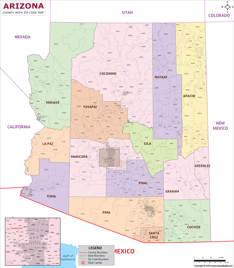
Arizona’s vast and varied geography is reflected in its complex zip code distribution. From the bustling urban centers to the remote desert expanses and mountainous regions, each zip code tells a story about the area it serves.
Urban Hubs and Their Codes
Major metropolitan areas in Arizona, such as Phoenix and Tucson, have a high density of zip codes. These codes often subdivide large cities into smaller neighborhoods, districts, and commercial zones. For instance, the downtown core of Phoenix will have a different set of zip codes than its surrounding suburbs like Scottsdale or Mesa. These urban zip codes are typically associated with high population density, extensive commercial activity, and a wide array of services and attractions.
- Phoenix Metropolitan Area: This sprawling region encompasses numerous cities and towns, each with its own set of zip codes. Understanding these codes can help distinguish between central Phoenix, the affluent areas of Paradise Valley, the university towns of Tempe and Glendale, and the suburban enclaves.
- Tucson and Southern Arizona: Tucson, with its distinct Southwestern charm, also features a layered zip code system. Areas like Oro Valley and Sahuarita, though often considered part of the greater Tucson area, possess their own unique postal designations, reflecting their independent municipal identities and service areas.
Rural and Remote Regions
Conversely, vast areas of Arizona, particularly in the northern and western parts of the state, are sparsely populated. These regions often have fewer zip codes, with each code potentially covering a very large geographical area. These remote zip codes might serve small towns, Native American reservations, national forests, or vast stretches of desert. Identifying these areas through their zip codes can be an indicator of lower population density, a more rugged landscape, and a reliance on self-sufficiency.
- Northern Arizona: Areas around the Grand Canyon National Park or the San Francisco Peaks will have zip codes that often encompass large natural preserves and smaller, scattered communities.
- Western Arizona: The deserts bordering California and Nevada, such as those surrounding Lake Havasu City, will also exhibit zip codes that cover significant geographical distances between population centers.
Tribal Lands and Unique Geographies
Arizona is home to numerous Native American reservations, which are integral parts of the state’s cultural tapestry. These areas are also designated with specific zip codes, often reflecting their unique administrative structures and community centers. Understanding these zip codes can provide a glimpse into the specific governance and geographical boundaries of these sovereign nations.
Significance of Arizona Zip Codes for Travelers and Locals
Whether you’re planning a vacation, looking for accommodation, or simply trying to understand local demographics, Arizona zip codes offer valuable insights.

Navigating Destinations
For travelers, zip codes are an indispensable tool for navigation and planning. When searching for hotels in Sedona, for example, knowing the specific zip codes for different neighborhoods can help you find lodging close to hiking trails, art galleries, or the vibrant uptown district. Similarly, when exploring national parks like Saguaro National Park or Petrified Forest National Park, understanding the surrounding zip codes can help you locate nearby towns for supplies or accommodation.
Locating Accommodation
When booking a stay at a resort in Scottsdale or a cozy bed and breakfast in a historic town like Jerome, zip codes provide precise location data. This helps in verifying distances to attractions, assessing the accessibility of the area, and ensuring you’re booking into the desired part of a city or town. Many booking platforms use zip codes as a primary search filter, making them essential for finding the right place to stay.
Planning Activities and Attractions
Identifying the zip codes associated with key attractions, such as the Heard Museum in Phoenix, the Arizona-Sonora Desert Museum near Tucson, or the natural wonders of the Superstition Mountains, allows for more efficient route planning. It helps in grouping activities geographically, saving travel time, and maximizing your experience of Arizona’s diverse offerings.
Understanding Local Communities
For residents and those interested in the local fabric of Arizona, zip codes can offer clues about neighborhood characteristics. While not a definitive measure, zip codes can sometimes correlate with:
- Demographics: Certain zip codes may exhibit patterns in income levels, age distribution, and cultural makeup, often influenced by historical development and socioeconomic factors.
- Services and Amenities: The presence of specific types of businesses, schools, or public services can often be mapped to particular zip codes.
- Local Governance: Zip codes can help delineate boundaries for local government services, school districts, and community organizations.
Tools for Exploring Arizona Zip Codes
Accessing and understanding Arizona’s zip code information is straightforward with several readily available resources.
Online Mapping Services
Websites and applications like Google Maps, Apple Maps, and dedicated zip code lookup tools are invaluable. These platforms allow you to enter an address or a zip code to see its geographical location, surrounding areas, and points of interest. They are instrumental for planning road trips, finding specific businesses, or simply familiarizing yourself with a new area of the state.
USPS Resources
The official United States Postal Service website offers tools for finding zip codes by address or city and state. This is the most authoritative source for verifying postal codes and understanding delivery areas. They also provide information on geographical areas served by specific post offices.
Business and Real Estate Directories
Many business directories and real estate websites utilize zip codes extensively. These platforms can provide insights into local market trends, property values, and the distribution of businesses within specific zip code areas. For businesses looking to target specific customer bases, understanding zip code demographics is a cornerstone of their marketing strategy.
Beyond the Code: The Human Element of Arizona’s Geography
While zip codes provide a numerical framework, they represent vibrant communities, unique ecosystems, and rich histories. Each Arizona zip code is an invitation to explore:
- The vibrant arts scene in the Phoenix Art Museum’s zip code.
- The culinary delights found within Old Town Scottsdale.
- The serene desert landscapes surrounding a zip code in the Sonoran Desert.
- The historical significance embedded in the postal codes of towns like Bisbee or Tombstone.
By understanding and utilizing Arizona’s zip code system, you gain a more nuanced and practical perspective on this captivating state, enriching both your travel experiences and your appreciation for its diverse geography and communities.
LifeOutOfTheBox is a participant in the Amazon Services LLC Associates Program, an affiliate advertising program designed to provide a means for sites to earn advertising fees by advertising and linking to Amazon.com. Amazon, the Amazon logo, AmazonSupply, and the AmazonSupply logo are trademarks of Amazon.com, Inc. or its affiliates. As an Amazon Associate we earn affiliate commissions from qualifying purchases.