
California, a land renowned for its stunning coastline, diverse landscapes, and vibrant culture, is equally famous for a natural phenomenon that has profoundly shaped its geology, history, and very identity: earthquakes. The question “What is the big earthquake in California?” isn’t about a singular event but rather a collective consciousness surrounding the ever-present seismic activity that defines the Golden State. It refers to the understanding of the immense geological forces at play, the memory of devastating historical tremors, and the continuous scientific pursuit to comprehend and coexist with these powerful natural landmarks. This article delves into the essence of California’s seismic character, exploring the geology, significant events, and enduring impact of its “big earthquakes.”
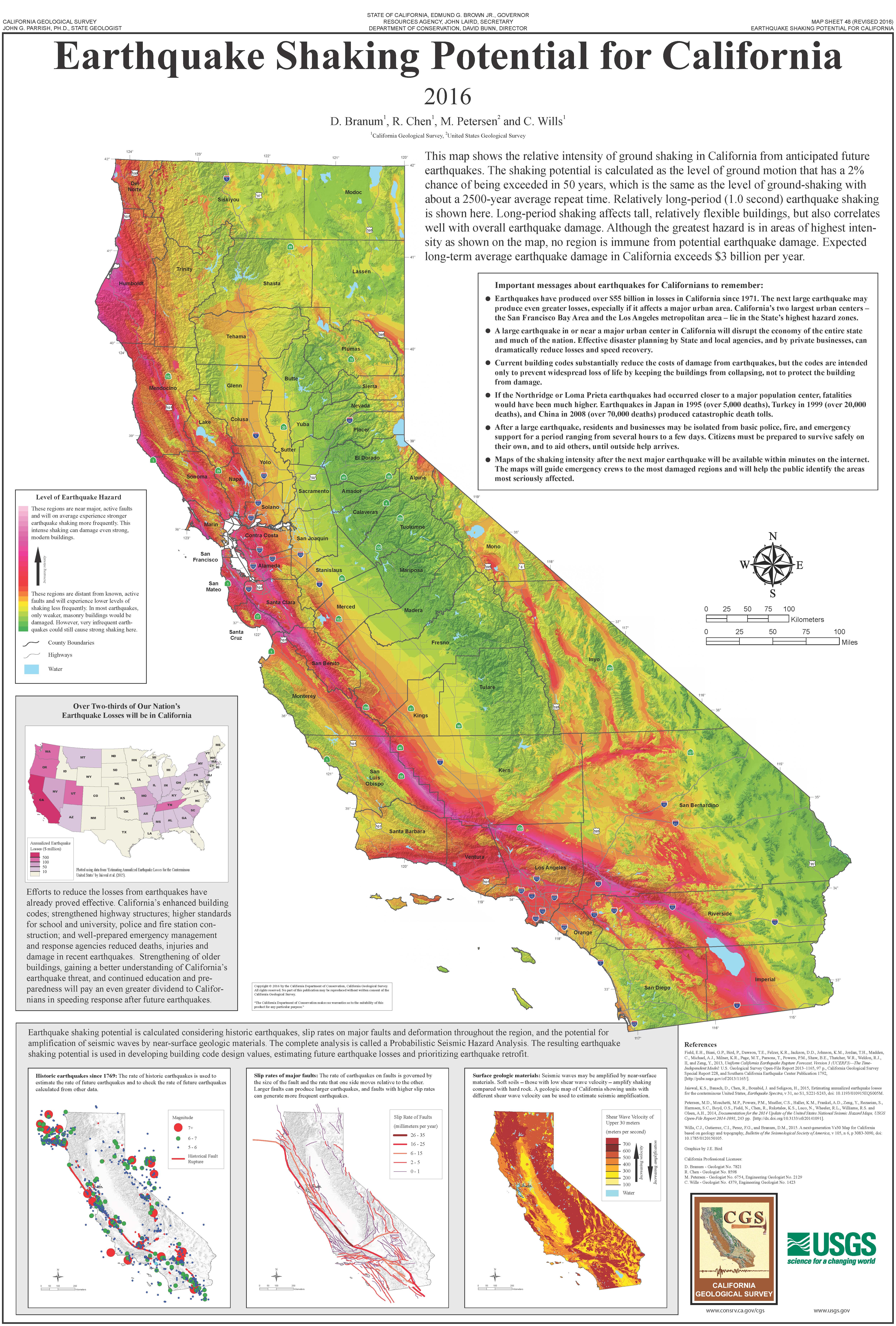
California: A Cradle of Seismic Activity
To understand the “big earthquake” in California, one must first grasp the fundamental geological setting that makes the region so tectonically active. California is situated at one of the most dynamic plate boundaries on Earth, a fact that makes seismic activity not an anomaly, but a defining feature of its natural landscape.
The Tectonic Dance: Pacific and North American Plates
The primary reason for California’s seismic dynamism lies in its position straddling the boundary between two colossal tectonic plates: the Pacific Plate and the North American Plate. Unlike boundaries where plates collide (convergent) or pull apart (divergent), this particular interface is a transform boundary. Here, the plates slide past each other horizontally. The Pacific Plate is moving northwestward relative to the North American Plate, a slow but relentless grind that averages a few centimeters per year—roughly the same rate at which your fingernails grow. This seemingly minor movement accumulates enormous stress over decades, centuries, and millennia, which is then periodically released in the form of earthquakes.
The Role of Fault Lines
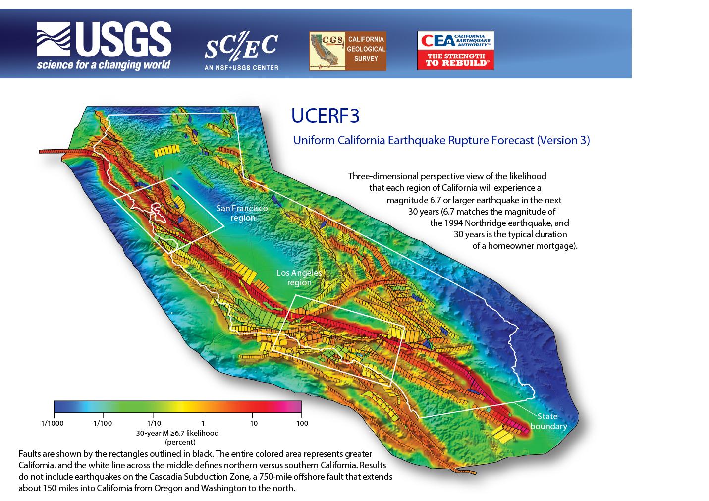
The friction between these massive landmasses doesn’t manifest as a smooth slide. Instead, the Earth’s crust is fragmented by an intricate network of fractures known as fault lines. These faults are the conduits for seismic energy release. While the San Andreas Fault is the most famous, it is far from the only one. California is crisscrossed by hundreds of known faults, both major and minor, including the Hayward Fault, the Garlock Fault, and numerous thrust faults beneath the Los Angeles basin. Each of these faults represents a historical or potential zone of rupture, contributing to the state’s complex seismic profile. Understanding this extensive fault system is crucial to appreciating why “the big earthquake” is not just a localized event, but a systemic natural phenomenon impacting the entire region.
The San Andreas Fault: California’s Most Famous Scar
When people think of “the big earthquake” in California, the San Andreas Fault often comes to mind immediately. It is the longest fault in California and one of the most studied geological features in the world, serving as a visceral, natural landmark of the state’s tectonic reality.
Anatomy of a Transform Boundary
Stretching for approximately 800 miles (1,300 kilometers) from the Mojave Desert to the northern coast near Point Arena, the San Andreas Fault is a textbook example of a right-lateral strike-slip fault. This means that if you stand on one side of the fault and look across, the opposite side appears to move to your right. It is not a single, continuous crack but rather a zone of deformation, often several miles wide, comprising multiple parallel or branching segments. This complex structure dictates how and where strain is accumulated and released, leading to variations in seismic behavior along its length. Its visible presence in certain areas, such as the Carrizo Plain, offers a stark and compelling natural landmark illustrating the relentless forces shaping our planet.
Creep vs. Locked Sections
The San Andreas Fault exhibits fascinating variations in its behavior. Some segments of the fault are said to “creep,” meaning they undergo slow, continuous movement that releases stress gradually without generating large earthquakes. An example of this is a section of the fault in central California, where the movement is measurable over years. However, other sections, particularly those near Los Angeles (the southern San Andreas Fault) and south of San Francisco (the northern San Andreas Fault), are “locked.” In these locked sections, the plates are stuck, and stress continues to build up over long periods. These are the segments most prone to generating the “big ones”—major earthquakes that represent a sudden, violent release of accumulated energy. The “Big Bend” segment, where the fault curves east in southern California, is particularly problematic as it introduces compression, further complicating the stress accumulation and increasing the potential for significant seismic events.
Echoes of the Past: Historic “Big Ones”
While the term “the big earthquake” is often used generically, several historical events stand out as particularly significant, leaving indelible marks on California’s physical and cultural landscape. These events are not just historical footnotes but powerful reminders of the state’s natural history.
The Great San Francisco Earthquake of 1906
The quintessential “big one” in California history is undoubtedly the Great San Francisco Earthquake of 1906. Occurring on April 18, 1906, at approximately 5:12 a.m., this colossal temblor is estimated to have had a Moment Magnitude Scale of 7.9. The rupture propagated along a staggering 296-mile (477-kilometer) section of the northern San Andreas Fault, with horizontal displacements of up to 20 feet (6 meters) in some areas. The earthquake itself caused widespread destruction, but the subsequent fires, fueled by ruptured gas lines and a compromised water supply, decimated much of San Francisco, Oakland, and other Bay Area communities. The event was a catastrophic natural disaster that reshaped the urban landscape and forced a profound re-evaluation of building practices and urban planning in a seismically active zone, serving as a benchmark in California’s natural history.
The 1989 Loma Prieta Earthquake
More recently, the 1989 Loma Prieta Earthquake, with a magnitude of 6.9, struck on October 17 during Game 3 of the World Series between the San Francisco Giants and the Oakland Athletics. Although not as powerful as the 1906 event, it caused significant damage, particularly in the San Francisco Bay Area. A section of the Bay Bridge collapsed, and a portion of the Cypress Street Viaduct in Oakland tragically pancaked, killing 42 people. The earthquake highlighted the vulnerability of infrastructure, especially in areas prone to liquefaction, such as San Francisco’s Marina District. It served as a stark reminder that even moderate-to-strong earthquakes can have devastating consequences, prompting significant investment in seismic retrofitting across the state.
The 1994 Northridge Earthquake
The 1994 Northridge Earthquake, a magnitude 6.7 event, struck the Los Angeles region early on the morning of January 17. Unlike the 1906 and 1989 earthquakes, Northridge was caused by a previously unknown “blind thrust fault,” a type of fault that doesn’t reach the Earth’s surface and thus provides no visible indication of its presence. This earthquake caused widespread structural damage, particularly to freeways, parking garages, and apartments in areas like Northridge, Santa Monica, Simi Valley, and Porter Ranch. Despite its moderate magnitude, the Northridge earthquake resulted in 57 deaths and an estimated $20 billion in damages, making it one of the costliest natural disasters in U.S. history. It underscored the complexity of California’s fault system and the ongoing challenge of identifying and assessing risks from hidden geological features.
Understanding the Seismic Threat: A Natural Phenomenon
To truly grasp the significance of “the big earthquake,” it’s essential to understand the scientific principles behind these powerful natural events. This scientific understanding frames earthquakes not just as destructive forces, but as fundamental processes of planetary geology.
Magnitude, Intensity, and the Richter Scale
The size of an earthquake is typically described using two main measurements: magnitude and intensity. Magnitude, historically measured by the Richter Scale and now more commonly by the Moment Magnitude Scale, quantifies the energy released at the earthquake’s source. It’s a single number for each event. The Moment Magnitude Scale is preferred by seismologists today as it more accurately reflects the total energy released, especially for larger earthquakes. Each whole number increase on the magnitude scale represents a tenfold increase in the measured amplitude of seismic waves and approximately 32 times more energy released.
Intensity, on the other hand, describes the effects of an earthquake at a specific location. It’s measured using the Modified Mercalli Intensity (MMI) Scale, which ranges from I (not felt) to XII (total destruction). Intensity varies depending on factors like distance from the epicenter, local geology, and building construction. While magnitude tells us about the power of the natural event, intensity informs us about its impact on the natural and built environment.
The Science of Foreshocks and Aftershocks
Earthquakes are rarely isolated events. They are often preceded by smaller tremors called foreshocks and followed by numerous aftershocks. Foreshocks are difficult to identify as such until after a larger earthquake has occurred, making them unreliable for prediction. Aftershocks, however, are a predictable consequence of a main earthquake. They represent the continuing readjustment of the Earth’s crust in the fault zone after the primary rupture. Aftershocks decrease in frequency and magnitude over time but can sometimes be strong enough to cause further damage to already weakened structures. Studying the patterns of foreshocks and aftershocks provides critical data for seismologists at institutions like the U.S. Geological Survey (USGS), helping them understand the mechanics of fault rupture and the long-term seismic behavior of a region.
Living with the Shifting Earth: California’s Evolving Relationship with Nature
The persistent threat and historical reality of “big earthquakes” have not deterred California’s growth but have rather molded its development, making it a unique example of human civilization adapting to a dynamic natural landscape. This ongoing interaction shapes its identity, transforming seismic risk into a defining characteristic.
Seismic Building Codes and Resilience
Perhaps the most tangible legacy of California’s seismic history is its rigorous approach to building construction. Following devastating events like the 1906 San Francisco earthquake and the 1933 Long Beach earthquake, which caused extensive damage to schools, the state pioneered and continuously updated some of the world’s most stringent seismic building codes. These codes mandate practices such as reinforcing structures with steel, ensuring flexible foundations, and prohibiting certain types of unreinforced masonry. While no building is entirely earthquake-proof, these regulations aim to make structures “earthquake-resilient,” designed to withstand significant shaking without collapsing, thereby minimizing loss of life and property. This commitment to structural integrity is a testament to the state’s long-term adaptation to its natural environment, turning a natural hazard into a catalyst for innovative engineering.

The Cultural Impact and Awareness
Beyond engineering, the “big earthquake” has deeply permeated California’s cultural fabric. There’s a collective awareness and a degree of preparedness that is perhaps unique to the state. Phrases like “earthquake country” are commonplace, and regular earthquake drills are part of school curricula. The ever-present knowledge of living atop active fault lines has fostered a distinctive blend of apprehension and resilience. It shapes discussions on urban development, infrastructure planning, and even individual household preparedness. The “big earthquake” is more than a potential future event; it is a historical landmark, a geological reality, and a psychological undercurrent that helps define what it means to live in California, making its relationship with the shifting earth an intrinsic part of its enduring character.
LifeOutOfTheBox is a participant in the Amazon Services LLC Associates Program, an affiliate advertising program designed to provide a means for sites to earn advertising fees by advertising and linking to Amazon.com. Amazon, the Amazon logo, AmazonSupply, and the AmazonSupply logo are trademarks of Amazon.com, Inc. or its affiliates. As an Amazon Associate we earn affiliate commissions from qualifying purchases.