
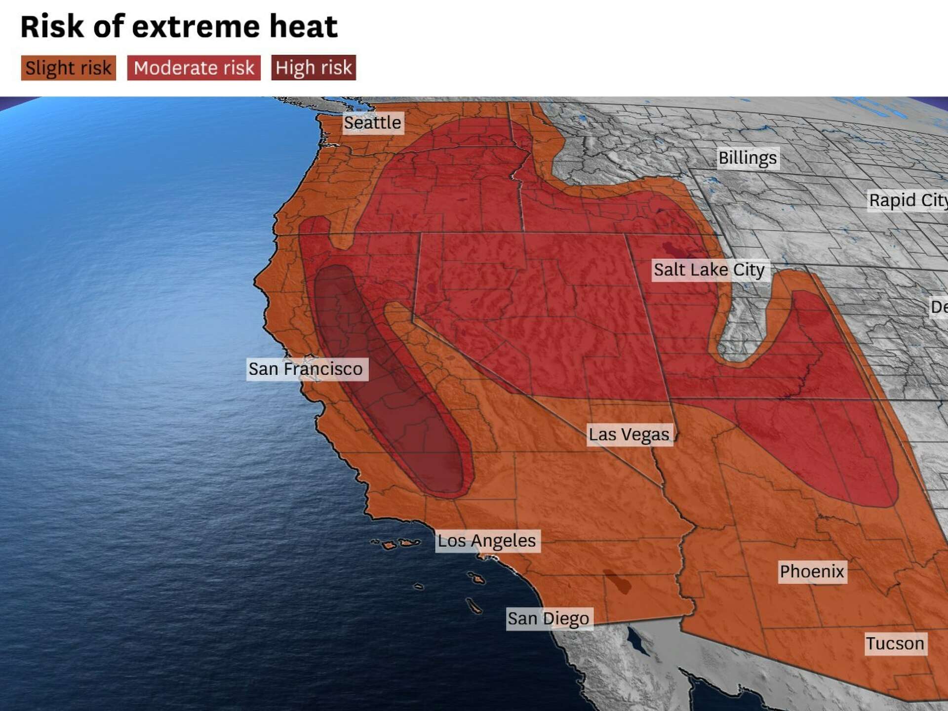
Southern California conjures images of endless sunshine, pristine beaches, and a vibrant outdoor lifestyle. While much of this image holds true, visitors and residents alike often encounter periods of intense heat that can be surprising, especially for those accustomed to milder climates. Understanding the complex interplay of geography, meteorology, and atmospheric phenomena is key to appreciating why this region, particularly its inland areas, can experience such scorching temperatures. For travelers planning a trip to iconic destinations like Los Angeles, San Diego, or the desert oases of Palm Springs, comprehending these factors is essential for a comfortable and enjoyable experience.
The Unique Geographical Blueprint
Southern California’s topography is a primary driver of its diverse climate zones, creating stark differences in temperature across relatively short distances. From the vast expanse of the Pacific Ocean to towering mountain ranges and sprawling deserts, each element plays a crucial role in shaping the regional heat patterns.
Coastal Influence and the Marine Layer
Along the immediate coastline, cities such as Santa Monica, Laguna Beach, and San Diego benefit significantly from the moderating influence of the Pacific Ocean. The cool ocean currents help to keep temperatures relatively mild year-round, often creating a natural air conditioning effect. A phenomenon known as the marine layer frequently forms, particularly in late spring and early summer (often dubbed “June Gloom” or “May Gray”). This low-lying cloud cover and fog act as a blanket, blocking direct sunlight and further cooling coastal communities. For travelers, this means that even during peak summer, a visit to the beach can offer a refreshing respite from inland heat. However, the marine layer usually “burns off” by midday, revealing the familiar sunny skies.
Inland Valleys and Desert Proximity
Venture just a few miles inland, and the landscape, along with the temperatures, undergoes a dramatic transformation. The coastal mountain ranges, including the Santa Monica Mountains and the Peninsular Ranges, act as formidable barriers. They block the cooling marine air from penetrating deep into the valleys, such as the San Fernando Valley in Los Angeles County or the Inland Empire in Riverside County and San Bernardino County.
These inland valleys, often bowl-shaped, trap heat efficiently. As air warms throughout the day, it becomes less dense and rises, but then cools and sinks, creating a stagnant, warm air mass. This effect is compounded by their proximity to vast desert regions, including the Mojave Desert and the Sonoran Desert. Desert climates are characterized by extreme temperature swings, with very hot days and cool nights. When winds blow from these desert areas, they carry superheated, dry air into the populated valleys, pushing temperatures dramatically higher.
Atmospheric Dynamics and Heat Domes
Beyond local geography, large-scale atmospheric patterns are critical in explaining Southern California’s heatwaves. These meteorological forces can override local conditions, leading to widespread and prolonged periods of extreme temperatures.
The Persistent Pacific High-Pressure System
A semi-permanent feature in the North Pacific Ocean is the Pacific High-Pressure System. This large area of high atmospheric pressure typically sits off the coast, rotating clockwise. Its presence generally leads to sinking air, which suppresses cloud formation and precipitation, contributing to Southern California’s characteristic sunny, dry weather, especially during the summer. While beneficial for clear skies, this system can also block cooler weather fronts from moving in.
Ridges of High Pressure and Heat Domes
During intense heatwaves, the Pacific High-Pressure System can strengthen and expand, forming what meteorologists call a “ridge of high pressure” or, more dramatically, a “heat dome.” When this occurs, a mass of warm air expands upwards and outward. As this air mass descends, it compresses, and as air compresses, it warms up (adiabatic heating). This creates a powerful lid over a region, trapping hot air near the surface and preventing cooler air from moving in or rising and cooling. The longer and stronger this ridge persists, the more intense and prolonged the heatwave becomes. This is a common culprit for record-breaking temperatures observed across Southern California during the summer and early fall.

The Infamous Santa Ana Winds
Perhaps the most dramatic and dangerous contributor to extreme heat in Southern California is the phenomenon of the Santa Ana winds. These hot, dry, and often powerful winds are notorious for pushing temperatures to dangerous levels and significantly elevating wildfire risk.
A Desert Breath: Origin and Mechanism
Santa Ana winds are a type of katabatic wind, originating from the high-pressure systems over the deserts of Nevada and Utah, or the interior of California’s Great Basin. As this cold, dense air mass moves westward, it is forced to descend through mountain passes and canyons, such as the Santa Ana Mountains (from which they derive their name, although they occur across much of the region) and the San Gabriel Mountains.
During this descent, the air undergoes significant adiabatic compression, meaning it is heated by the increased atmospheric pressure. It can warm by as much as 5.5°F for every 1,000 feet it drops. Simultaneously, the air becomes extremely dry as any moisture is wrung out during its initial descent on the desert side of the mountains. By the time these winds reach coastal Southern California, they are blazing hot, exceedingly dry, and often gusty. These winds effectively sweep away the cooler, moist marine layer, allowing the sun’s full intensity to beat down on already heated air, resulting in exceptionally high temperatures, particularly in areas like Orange County, Ventura County, and the valleys of Los Angeles.
Climate Change and Future Trends
The underlying geographical and meteorological factors have always made Southern California prone to heat. However, the influence of global climate change is undeniably amplifying these events. Scientific research indicates that heatwaves are becoming more frequent, lasting longer, and reaching higher intensities across the region. This means that travelers planning future visits should be prepared for potentially hotter conditions than in previous decades. The window for extreme heat events is also expanding, with intense heat now possible earlier in spring and later into fall.
Navigating the Heat: A Traveler’s Guide
For travelers, understanding why Southern California gets so hot is not just academic; it’s practical knowledge for planning an unforgettable trip.
Timing Your Visit
If extreme heat is a concern, consider visiting in spring (March to May) or fall (September to November). These shoulder seasons offer generally pleasant temperatures, fewer crowds, and a lower likelihood of intense heatwaves, especially away from the immediate coast. Summer (June to August) is peak season for coastal enjoyment but also when inland areas are most susceptible to scorching temperatures.
Packing Smart and Staying Hydrated
Regardless of when you visit, always pack light, breathable clothing (cotton or linen are excellent choices). A wide-brimmed hat, sunglasses, and high-SPF sunscreen are non-negotiable for protection against the intense sun. Hydration is paramount: carry a reusable water bottle and refill it frequently. Many attractions, like the Getty Center or Universal Studios Hollywood, have water fountains or places to purchase beverages.

Adapting Activities to the Climate
On hot days, strategic planning can make all the difference. Schedule outdoor activities, such as hiking in Runyon Canyon Park or exploring Joshua Tree National Park, for early mornings or late afternoons when temperatures are cooler. During the midday peak, seek refuge in air-conditioned indoor attractions. Los Angeles boasts world-class museums like the Los Angeles County Museum of Art (LACMA) and the California Science Center, or indulge in some retail therapy at The Grove. Iconic landmarks such as Griffith Observatory offer indoor exhibits with breathtaking views.
Remember that the coastal areas consistently offer a cooler escape. A day trip to Malibu, Santa Barbara, or even just enjoying the Santa Monica Pier can provide a refreshing change of pace from the inland heat. By understanding the unique climatological dance of Southern California, travelers can confidently plan a trip that embraces the region’s famed sunshine while staying comfortable and safe, even when the mercury rises.
LifeOutOfTheBox is a participant in the Amazon Services LLC Associates Program, an affiliate advertising program designed to provide a means for sites to earn advertising fees by advertising and linking to Amazon.com. Amazon, the Amazon logo, AmazonSupply, and the AmazonSupply logo are trademarks of Amazon.com, Inc. or its affiliates. As an Amazon Associate we earn affiliate commissions from qualifying purchases.